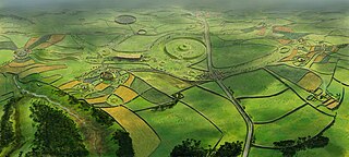
Rathcroghan is a complex of archaeological sites near Tulsk in County Roscommon, Ireland. It is identified as the site of Cruachan, the traditional capital of the Connachta, the prehistoric and early historic rulers of the western territory. The Rathcroghan Complex is a unique archaeological landscape with many references found in early Irish medieval manuscripts.

A causewayed enclosure is a type of large prehistoric earthwork common to the early Neolithic in Europe. It is an enclosure marked out by ditches and banks, with a number of causeways crossing the ditches. More than 100 examples are recorded in France and 70 in Southern England and Wales, while further sites are known in Scandinavia, Belgium, Germany, Italy, Ireland and Slovakia.
Combe Hill is a causewayed enclosure, near Eastbourne in East Sussex, on the northern edge of the South Downs. It consists of an inner circuit of ditches and banks, incomplete where it meets a steep slope on its north side, and the remains of an outer circuit. Causewayed enclosures were built in England from shortly before 3700 BC until at least 3500 BC; they are characterized by the full or partial enclosure of an area with ditches that are interrupted by gaps, or causeways. Their purpose is not known; they may have been settlements, meeting places, or ritual sites. The historian Hadrian Allcroft included the site in his 1908 book Earthwork of England, and in 1930 E. Cecil Curwen listed it as a possible Neolithic site in a paper which attempted to provide the first list of all the causewayed enclosures in England.

Bedd Arthur is a possibly Neolithic hengiform monument megalithic site in the Preseli Hills in the Welsh county of Pembrokeshire. Thirteen upright stones and at least 2 fallen ones, each around 0.6 metres (2.0 ft) high form an oval horseshoe with similarities to the earliest form of Stonehenge.

The Newgrange cursus is a Neolithic monument used as a ceremonial procession route within the Brú na Bóinne complex. The ancient trackway is 100m long and 20m wide. It is located at Newgrange, in County Meath, Ireland.

Carl Wark is a rocky promontory on Hathersage Moor in the Peak District National Park, just inside the boundary of Sheffield, England. The promontory is faced by vertical cliffs on all but one side, which is protected by a prehistoric embankment. The cliffs and embankment form an enclosure that has been interpreted as an Iron Age hill fort, though the date of construction and purpose of the fortifications remains unknown. The site is a scheduled monument.
Robin Hood’s Ball is a Neolithic causewayed enclosure on Salisbury Plain in Wiltshire, England, approximately 5 miles (8 km) northwest of the town of Amesbury, and 2+1⁄2 miles (4.0 km) northwest of Stonehenge. The site was designated as a scheduled monument in 1965.

In archaeology, earthworks are artificial changes in land level, typically made from piles of artificially placed or sculpted rocks and soil. Earthworks can themselves be archaeological features, or they can show features beneath the surface.

The Trundle is an Iron Age hillfort on St Roche's Hill about 4 miles (6 km) north of Chichester, West Sussex, England. It was built on the site of a causewayed enclosure, a form of early Neolithic earthwork found in northwestern Europe. Causewayed enclosures were built in England from shortly before 3700 BC until at least 3500 BC; they are characterized by the full or partial enclosure of an area with ditches that are interrupted by gaps, or causeways. Their purpose is not known; they may have been settlements, meeting places, or ritual sites. Hillforts were built as early as 1000 BC, in the Late Bronze Age, and continued to be built through the Iron Age until shortly before the Roman occupation.

Scratchbury Camp is the site of an Iron Age univallate hillfort on Scratchbury Hill, overlooking the Wylye valley about 1 km northeast of the village of Norton Bavant in Wiltshire, England. The fort covers an area of 37 acres (15 ha) and occupies the summit of the hill on the edge of Salisbury Plain, with its four-sided shape largely following the natural contours of the hill.

Bury Camp is the site of an Iron Age multivallate hillfort in north-west Wiltshire, England. It occupies a triangular promontory of Colerne Down, in the north of Colerne parish, at the southern edge of the Cotswold Hills between two spurs of a river valley. The enclosed area of approximately 9.2ha is surrounded by a ditch 4m wide and up to 1m deep, and an outer rampart up to 1.5m high on the east and northwestern sides and up to 2m high on the southwestern side, across the neck of the promontory.
Hillforts in Britain refers to the various hillforts within the island of Great Britain. Although the earliest such constructs fitting this description come from the Neolithic British Isles, with a few also dating to later Bronze Age Britain, British hillforts were primarily constructed during the British Iron Age. Some of these were apparently abandoned in the southern areas that were a part of Roman Britain, although at the same time, those areas of northern Britain that remained free from Roman occupation saw an increase in their construction. Some hillforts were reused in the Early Middle Ages, and in some rarer cases, into the Later Medieval period as well. By the early modern period, these had essentially all been abandoned, with many being excavated by archaeologists in the nineteenth century onward.

Caerau Hillfort is a large triangular multivallate Iron Age hillfort, built on a previously occupied Neolithic site, occupying the western tip of an extensive ridge-top plateau in the western suburbs of Caerau and Ely, Cardiff, Wales. It is the largest Iron Age site of its type in south Wales and also one of the largest in Great Britain. The old parish church, St Mary's, and a small ringwork, almost certainly a medieval castle site probably contemporary with the church, stand within the hillfort on the north-eastern side.

Knook Castle is the site of an Iron Age univallate hillfort on Knook Down, near the village of Knook in Wiltshire, England, but largely within the civil parish of Upton Lovell. It has also been interpreted as a defensive cattle enclosure associated with nearby Romano-British settlements. It is roughly rectangular in plan with a single entrance on the south/south-east side, but with a later break in the wall on the western side. The site is a scheduled monument.

Coity Higher is a community in Bridgend County Borough, south Wales. It contains the north western suburbs of Bridgend which includes the villages of Litchard and Coity. The southern boundary of the community adjoins the community of Brackla, while the northern border is defined by the M4 motorway. Notable buildings and landmarks within the community include Coity Castle, Parc Prison, the 14th century Church of St Mary, Pendre Hospital, Ty Mawr House and a burial chamber. At the 2001 census, the community's population was 835, being re-measured at 6,078 t the 2011 Census.

The architecture of Scotland in the prehistoric era includes all human building within the modern borders of Scotland, before the arrival of the Romans in Britain in the first century BCE. Stone Age settlers began to build in wood in what is now Scotland from at least 8,000 years ago. The first permanent houses of stone were constructed around 6,000 years ago, as at Knap of Howar, Orkney and settlements like Skara Brae. There are also large numbers of chambered tombs and cairns from this era, particularly in the west and north. In the south and east there are earthen barrows, often linked to timber monuments of which only remnants remain. Related structures include bank barrows, cursus monuments, mortuary enclosures and timber halls. From the Bronze Age there are fewer new buildings, but there is evidence of crannogs, roundhouses built on artificial islands and of Clava cairns and the first hillforts. From the Iron Age there is evidence of substantial stone Atlantic roundhouses, which include broch towers, smaller duns. There is also evidence of about 1,000 hillforts in Scotland, most located below the Clyde-Forth line.

Knap Hill lies on the northern rim of the Vale of Pewsey, in northern Wiltshire, England, about a mile north of the village of Alton Priors. At the top of the hill is a causewayed enclosure, a form of Neolithic earthwork that was constructed in England from about 3700 BC onwards, characterized by the full or partial enclosure of an area with ditches that are interrupted by gaps, or causeways. Their purpose is not known: they may have been settlements, or meeting places, or ritual sites of some kind. The site has been scheduled as an ancient monument.
Morvil or Morfil is a remote upland parish on the southern slopes of the Preseli Mountains in north Pembrokeshire, Wales. Fishguard is 6 miles (10 km) to the northwest. The area was occupied in neolithic and Norman times, and in the past two centuries has been sparsely populated with no significant settlements developing. The parish church is dedicated to St John the Baptist.
Barkhale Camp is a Neolithic causewayed enclosure, an archaeological site on Bignor Hill, on the South Downs in West Sussex, England. Causewayed enclosures were built in England from shortly before 3700 BC until at least 3500 BC; they are characterized by the full or partial enclosure of an area with ditches that are interrupted by gaps, or causeways. Their purpose is not known; they may have been settlements, meeting places, or ritual sites. The Barkhale Camp enclosure was first identified in 1929, by John Ryle, and was surveyed the following year by E. Cecil Curwen, who listed it as a possible Neolithic site in a 1930 paper which was the first attempt to list all the causewayed enclosures in England.
Huckhoe Settlement is an archaeological site in Northumberland, England, near the village of Bolam and about 7 miles (11 km) west of Morpeth. The site shows occupation, in at least four phases, dating from the early Iron Age to the post-Roman period. It is a scheduled monument.
