
The geography of France consists of a terrain that is mostly flat plains or gently rolling hills in the north and west and mountainous in the south and the east. Metropolitan France has a total size of 551,695 km2 (213,011 sq mi). It is the third largest country in Europe by area and the largest in Western Europe.

The Arctic Archipelago, also known as the Canadian Arctic Archipelago, is an archipelago lying to the north of the Canadian continental mainland, excluding Greenland and Iceland.

USS Block Island (CVE-21/AVG-21/ACV-21) was a Bogue-class escort carrier for the United States Navy during World War II. She was the first of two escort carriers named after Block Island Sound off Rhode Island and was the only American carrier sunk in the Atlantic during the war.
The Reedy Glacier is a major glacier in Antarctica, over 100 nautical miles long and 6 to 12 nautical miles wide, descending from the polar plateau to the Ross Ice Shelf between the Michigan Plateau and Wisconsin Range in the Transantarctic Mountains. It marks the limits of the Queen Maud Mountains on the west and the Horlick Mountains on the east.
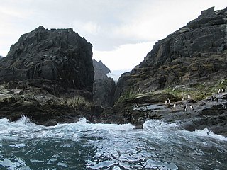
Rowett Island is a rocky island 0.5 miles (0.8 km) long, lying immediately off Cape Lookout, Elephant Island, in the South Shetland Islands. Rowett Island is located at 61°17′S55°13′W. Rowett Island was known to American and British sealers as early as 1822. Rowett Island was named by members of a British expedition (1921-1922) under Ernest Shackleton for John Quiller Rowett, chief patron of the expedition.
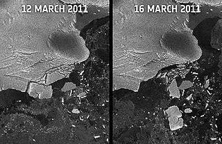
Sulzberger Bay is a bay indenting the front of the Sulzberger Ice Shelf between Fisher Island and Vollmer Island, along the coast of Marie Byrd Land, Antarctica.

El Robledo is a municipality in Ciudad Real, Castile-La Mancha, Spain. It has a population of 1,084.

Passabém is a Brazilian municipality located in the state of Minas Gerais. The city belongs to the mesoregion Metropolitana de Belo Horizonte and to the microregion of Conceição do Mato Dentro. As of 2020, the estimated population was 1,633.

Shambles Glacier is a steep glacier 4 miles (6 km) long and 6 miles (10 km) wide, with very prominent hummocks and crevasses, flowing east between Mount Bouvier and Mount Mangin into Stonehouse Bay on the east side of Adelaide Island. It is the island's largest glacier, and provides an eastern outlet from the giant Fuchs Ice Piedmont which covers the entire western two-thirds of the island. In doing so, Shambles Glacier provides the largest 'gap' in Adelaide Island's north–south running mountain chain.
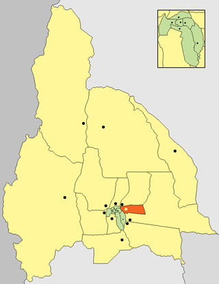
San Martín is a department in the east of San Juan province (Argentina). It is predominantly a landscape of mountains in the east and significant production wine, with the installation of prestigious wineries with a remarkable track record in the province known nationally by the development of wine table and fine wine.

The Adare Peninsula, is a high ice-covered peninsula, 40 nautical miles long, in the northeast part of Victoria Land, extending south from Cape Adare to Cape Roget. The peninsula was named by the New Zealand Antarctic Place-Names Committee (NZ-APC) for Cape Adare. The peninsula is considered the southernmost point of the Borchgrevink Coast, named for Carsten Borchgrevink (1864-1934).
On the continent of Antarctica, the Aramis Range is the third range south in the Prince Charles Mountains, situated 11 miles southeast of the Porthos Range and extending for about 30 miles in a southwest–northeast direction. It was first visited in January 1957 by Australian National Antarctic Research Expeditions (ANARE) southern party led by W.G. Bewsher, who named it for a character in Alexandre Dumas' novel The Three Musketeers, the most popular book read on the southern journey.
Buchia Buttress is a rock buttress at the southwest end of Mount Bouvier on eastern Adelaide Island. This geological locality was investigated by the British Antarctic Survey, 1980–81, and found to contain marine fossils, including a bivalve species of the genus Buchia. The buttress was so was named by the UK Antarctic Place-Names Committee in 1982.
Neptune Glacier is a glacier on the east coast of Alexander Island, Antarctica, 12 nautical miles (22 km) long and 4 nautical miles (7 km) wide, flowing east into George VI Sound and the George VI Ice Shelf to the south of Triton Point. Although Neptune Glacier is not located within the mountain range Planet Heights, the glaciers name derives from the mountain range along with many other nearby glaciers named after planets of the Solar System. There are also other nearby landforms named in association with these glaciers. The glacier was first sighted from the air by Lincoln Ellsworth on November 23, 1935, and roughly mapped from photos obtained on that flight by W.L.G. Joerg. The mouth of the glacier was positioned in 1936 by the British Graham Land Expedition (BGLE). Named by the United Kingdom Antarctic Place-Names Committee (UK-APC) for the planet Neptune following a Falkland Islands Dependencies Survey (FIDS) survey in 1949. The head of the glacier was mapped from air photos taken by the Ronne Antarctic Research Expedition (RARE), 1947–48, by Searle of the FIDS in 1960.
Planet Heights is a series of summits running along an ice-free ridge, extending 24 nautical miles (44 km) in a north-south direction between the southernmost extremity of the LeMay Range and George VI Sound in the east part of Alexander Island, Antarctica. Many landforms and nearby features are named in association with this mountain range; some of these include landforms named after astronomers, satellites, planets and other things related to astrology and astrophysics. The mountain range was first mapped from air photos taken by the Ronne Antarctic Research Expedition (RARE), 1947–48, by Searle of the Falkland Islands Dependencies Survey (FIDS) in 1960. Named by the United Kingdom Antarctic Place-Names Committee (UK-APC) from association with the nearby glaciers named for planets of the Solar System. The only planet that is not featured in any of these glaciers is the planet Earth, as there are no glaciers named "Earth Glacier" and this glacier does not exist.

Schneider Glacier is a glacier in the Heritage Range in Antarctica. It is 15 nautical miles long, draining north between the Dunbar and Inferno Ridge and coalescing with Balish Glacier before entering the Splettstoesser Glacier. It was mapped by United States Geological Survey (USGS) from surveys and U.S. Navy air photos, 1961–66. It was named by Advisory Committee on Antarctic Names (US-ACAN) for Commander Arthur F. Schneider, Maintenance Officer of U.S. Navy Squadron VX-6 during Deep Freeze 1965, and Commanding Officer in 1968.
Mount Tidd is a prominent rock peak which is the highest summit in Pirrit Hills. The peak was positioned by the U.S. Ellsworth-Byrd Traverse Party on December 10, 1958. It was named by the Advisory Committee on Antarctic Names (US-ACAN) for Lieutenant Paul Tidd of the U.S. Navy, who was the Officer-in-Charge of Ellsworth Station in 1958.
The Allegheny Mountains are a small group of mountains 10 nautical miles west of the Clark Mountains in the Ford Ranges of Marie Byrd Land, Antarctica.
