Related Research Articles

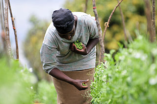
Bangladesh is a densely populated, low-lying, mainly riverine country located in South Asia with a coastline of 580 km (360 mi) on the northern littoral of the Bay of Bengal. The delta plain of the Ganges (Padma), Brahmaputra (Jamuna), and Meghna Rivers and their tributaries occupy 79 percent of the country. Four uplifted blocks occupy 9 percent and steep hill ranges up to approximately 1,000 metres (3,300 ft) high occupy 12 percent in the southeast and in the northeast. Straddling the Tropic of Cancer, Bangladesh has a tropical monsoon climate characterised by heavy seasonal rainfall, high temperatures, and high humidity. Natural disasters such as floods and cyclones accompanied by storm surges periodically affect the country. Most of the country is intensively farmed, with rice the main crop, grown in three seasons. Rapid urbanisation is taking place with associated industrial and commercial development. Exports of garments and shrimp plus remittances from Bangladeshis working abroad provide the country's three main sources of foreign exchange income.
The Delta Works is a series of construction projects in the southwest of the Netherlands to protect a large area of land around the Rhine–Meuse–Scheldt delta from the sea. Constructed between 1954 and 1997, the works consist of dams, sluices, locks, dykes, levees, and storm surge barriers located in the provinces of South Holland and Zeeland.
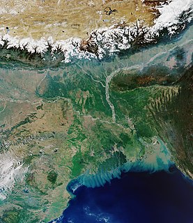
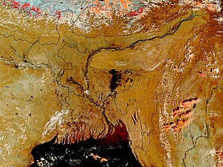
The Ganges Delta is a river delta in the Bengal region of South Asia, consisting of Bangladesh and the Indian state of West Bengal. It is the world's largest river delta and it empties into the Bay of Bengal with the combined waters of several river systems, mainly those of the Brahmaputra river and the Ganges river. It is also one of the most fertile regions in the world, thus earning the nickname the Green Delta. The delta stretches from the Hooghly River east as far as the Meghna River.

Barasat is a city and a municipality of North 24 Parganas district in the Indian state of West Bengal. It is the headquarters of Barasat Sadar subdivision. It is close to Kolkata and also a part of the area covered by Kolkata Metropolitan Development Authority (KMDA).Located in the Ganges delta, Barasat is a regional transportation hub as a rail and road junction. National Highway 12, NH 112, Taki Road and Barrackpore-Barasat Road are the main connectivity links to the city.

Sundarbans is a mangrove area in the delta formed by the confluence of the Padma, Brahmaputra and Meghna Rivers in the Bay of Bengal. It spans the area from the Baleswar River in Bangladesh's division of Khulna to the Hooghly River in India's state of West Bengal. It comprises closed and open mangrove forests, land used for agricultural purpose, mudflats and barren land, and is intersected by multiple tidal streams and channels. Four protected areas in the Sundarbans are enlisted as UNESCO World Heritage Sites, viz. Sundarbans West (Bangladesh), Sundarbans South (Bangladesh), Sundarbans East (Bangladesh) and Sundarbans National Park (India).

Environmental migrants are people who are forced to leave their home region due to sudden or long-term changes to their local or regional environment. These changes compromise their well-being or livelihood, and include increased drought, desertification, sea level rise, and disruption of seasonal weather patterns. The degree to which some of these changes occur can be reduced by means of climate adaptation projects. Climate refugees may flee or migrate to another country, or they may migrate internally within their own country.[2] Though there is no uniform, clear-cut definition of environmental migration, the idea is gaining attention as policy-makers and environmental and social scientists attempt to conceptualize the potential social effects of climate change and environmental degradation.
Because Bangladesh is a land of many rivers. It is very prone to flooding due to being situated on the Brahmaputra River Delta and the many distributaries flowing into the Bay of Bengal. Due to being part of such a basin and being less than 5 metres above mean sea level, Bangladesh faces the cumulative effects of floods due to water flashing from nearby hills, the accumulation of the inflow of water from upstream catchments, and locally heavy rainfall enhanced by drainage congestion. Bangladesh faces this problem almost every year. Coastal flooding, combined with the bursting of river banks is common, and severely affects the landscape and society of Bangladesh. 80% of Bangladesh is [floodplain], and it has an extensive sea coastline, rendering the nation very much at risk of periodic widespread damage. Whilst more permanent defenses, strengthened with reinforced concrete, are being built, many embankments are composed purely of soil and turf and made by local farmers. Flooding normally occurs during the monsoon season from June to September. The convectional rainfall of the monsoon is added to by relief rainfall caused by the Himalayas. Meltwater from the Himalayas is also a significant input.

Freshwater swamp forests, or flooded forests, are forests which are inundated with freshwater, either permanently or seasonally. They normally occur along the lower reaches of rivers and around freshwater lakes. Freshwater swamp forests are found in a range of climate zones, from boreal through temperate and subtropical to tropical.
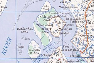
Lohachara Island was an islet which was permanently flooded in the 1980s. It was located in the Hooghly River as part of the Sundarban delta in the Sundarban National Park, located near the Indian state of West Bengal. The definite disappearance of the island was reported by Indian researchers in December 2006, which led to international press coverage. No specific study was ever done to prove that the island was permanently inundated because of sea level rise.
New Moore, also known as South Talpatti and Purbasha Island, was a small uninhabited offshore sandbar island in the Bay of Bengal, off the coast of the Ganges-Brahmaputra delta region. It emerged in the Bay of Bengal in the aftermath of the Bhola cyclone in November 1970, and disappeared around March 2010.
Climate change in South Asia is having significant impacts already which are expected to intensify as global temperatures rise due to climate change. The South Asia region consists of the eight countries Afghanistan, Pakistan, India, Nepal, Bhutan, Bangladesh, the Maldives and Sri Lanka. In the 2017 edition of Germanwatch's Climate Risk Index, Bangladesh and Pakistan ranked sixth and seventh respectively as the countries most affected by climate change in the period from 1996 to 2015, while India ranked fourth among the list of countries most affected by climate change in 2015. South Asia is one of the most vulnerable regions globally to a number of direct and indirect effects of climate change, including sea level rise, cyclonic activity, and changes in ambient temperature and precipitation patterns. Ongoing sea level rise has already submerged several low-lying islands in the Sundarbans region, displacing thousands of people.

Natural catastrophe in India, many of them related to the climate of India, cause massive losses of life and property. Droughts, flash floods, cyclones, avalanches, landslides brought by torrential rains, and snowstorms pose the greatest threats. A natural disaster might be caused by earthquakes, flooding, volcanic eruption, landslides, hurricanes etc. In order to be classified as a disaster, it will need to have a profound environmental effect and/or human loss and frequently incurs a financial loss. Other dangers include frequent summer dust storms, which usually track from north to south; they cause extensive property damage in North India and deposit large amounts of dust and dirt from arid regions. Hail is also common in parts of India, causing severe damage to standing crops such as rice and wheat and many more crops.

Tide gauge measurements show that the current global sea level rise began at the start of the 20th century. Between 1901 and 2018, the globally averaged sea level rose by 15–25 cm (6–10 in). More precise data gathered from satellite radar measurements reveal an accelerating rise of 7.5 cm (3 in) from 1993 to 2017, for an average rate of 31 mm per decade. This acceleration is due mostly to climate change, which heats the ocean and melts the land-based ice sheets and glaciers. Between 1993 and 2018, the thermal expansion of water contributed 42% to sea level rise; melting of temperate glaciers, 21%; Greenland, 15%; and Antarctica, 8%. Climate scientists expect the rate to further accelerate during the 21st century, with the latest measurements saying the sea levels are rising by 3.7 mm per year.
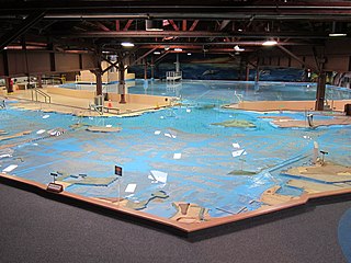
The U.S. Army Corps of Engineers Bay Model is a working hydraulic scale model of the San Francisco Bay and Sacramento-San Joaquin River Delta System. While the Bay Model is still operational, it is no longer used for scientific research but is instead open to the public alongside educational exhibits about Bay hydrology. The model is located in the Bay Model Visitor Center at 2100 Bridgeway Blvd. in Sausalito, California.
Water resources management in modern Egypt, is a complex process that involves multiple stakeholders who use water for irrigation, municipal and industrial water supply, hydropower generation and navigation. In addition, the waters of the Nile support aquatic ecosystems that are threatened by abstraction and pollution. Egypt also has substantial fossil groundwater resources in the Western Desert.

Climate change in Bangladesh is a critical issue as the country is one of the most vulnerable to the effects of climate change. In the 2020 edition of Germanwatch's Climate Risk Index, it ranked seventh in the list of countries most affected by climate calamities during the period 1999–2018. Bangladesh's vulnerability to climate change impacts is due to a combination of geographical factors, such as its flat, low-lying, and delta-exposed topography, and socio-economic factors, including its high population density, levels of poverty, and dependence on agriculture.
Climate change and gender is a way to interpret the disparate impacts of climate change on men and women, based on the social construction of gender roles and relations. Climate change increases gender inequality, reduces women's ability to be financially independent, and has an overall negative impact on the social and political rights of women, especially in economies that are heavily based on agriculture. In many cases, gender inequality means that women are more vulnerable to the negative effects of climate change. This is due to gender roles, particularly in the developing world, which means that women are often dependent on the natural environment for subsistence and income. By further limiting women's already constrained access to physical, social, political, and fiscal resources, climate change often burdens women more than men and can magnify existing gender inequality.
Water Resources Planning Organisation is an autonomous national organisation responsible for the implementation of water resource planning in Bangladesh and is located in Dhaka, Bangladesh.

Climate change in India is having profound effects on India, which is ranked fourth among the list of countries most affected by climate change in 2015. India emits about 3 gigatonnes (Gt) CO2eq of greenhouse gases each year; about two and a half tons per person, which is less than the world average. The country emits 7% of global emissions, despite having 17% of the world population. Temperature rises on the Tibetan Plateau are causing Himalayan glaciers to retreat, threatening the flow rate of the Ganges, Brahmaputra, Yamuna and other major rivers. A 2007 World Wide Fund for Nature (WWF) report states that the Indus River may run dry for the same reason. Heat waves' frequency and power are increasing in India because of climate change. Severe landslides and floods are projected to become increasingly common in such states as Assam.
The SAARC Meteorological Research Centre was a meteorological research centre in Dhaka, Bangladesh which was operated by the South Asian Association for Regional Cooperation.
References
- ↑ M. A. Sarker. "Bangladesh Delta Plan (BDP) 2100. Volume 1: Strategy" (PDF).
- ↑ W. Veerbeek, UNESCO-IHE, Institute for Water Education. "Bangladesh Delta Plan 2100 Formulation Project".
{{cite web}}: CS1 maint: multiple names: authors list (link) - ↑ Roome, J. (11 June 2021). "Implementing Bangladesh Delta Plan 2100". The Financial Express.
| | This Bangladesh-related article is a stub. You can help Wikipedia by expanding it. |