Bansang

Last updated
Bansang
Gambia bansang havard.jpg
Gambia adm location map.svg
Red pog.svg
Bansang
Location in the Gambia
Coordinates: 13°26′N14°39′W / 13.433°N 14.650°W / 13.433; -14.650
Country The Gambia
Division Central River Division
District Fulladu West
Population
 (2012)
  Total8,843
Time zone UTC+0 (GMT)

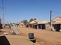
Bansang is a town in the Central River Division of the Gambia, with a population of 8,843 (2012). Although the official government center of the Division is located in Janjanbureh downstream, Bansang has better access to the more affluent coastal region of the country, and is sometimes considered the unofficial "upcountry" economic capital.[ dubious ]

Contents

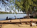
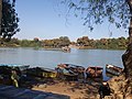
The town is a market for peanuts, rice and fish. [1]

History

The area was originally part of the kingdoms of Jimara and Wuropana, constituent states of the Kaabu empire. In the 1860s the Fula kingdom of Fuladu rose as Kaabu declined.

Bansang became an important settlement during the colonial period as families settled there to take advantage of opportunities in the growing trade of peanuts on the Gambia river. Mandinka people were the earliest founders, followed by Fula and Wolof in the 20th century. [2] The village began as a seasonally inhabited trading post, until the first compound was founded by a prosperous local trader, Bakary Darboe, in the 1920s. His family was followed by relatives of Musa Molloh Balde  [ fr ], ruler of Fuladu. [3]

Sources

13°26′N14°39′W / 13.433°N 14.650°W / 13.433; -14.650

Related Research Articles

<span class="mw-page-title-main">Guinea-Bissau</span> Country in West Africa

Guinea-Bissau, officially the Republic of Guinea-Bissau, is a country in West Africa that covers 36,125 square kilometres (13,948 sq mi) with an estimated population of 2,026,778. It borders Senegal to its north and Guinea to its southeast. Guinea-Bissau is the only Portuguese-speaking country in which Islam is the predominant religion.

Guinea-Bissau was claimed by Portugal from the 1450s to the 1970s. However, Portuguese control of the region was limited to forts along the coast. Portugal gained full control of the mainland after the pacification campaigns of 1912-15, the offshore Bijago islands weren't colonised until 1936 establishing total control of Guinea-Bissau. Since independence in 1974, the country was controlled by a single-party system until 1991. Following the introduction of multi-party politics in 1991, the first multi-party elections were held in 1994.

<span class="mw-page-title-main">The Gambia</span> Country in West Africa

The Gambia, officially the Republic of The Gambia, is a country in West Africa. It is the smallest country within mainland Africa and is surrounded by Senegal, except for its western coast on the Atlantic Ocean. The Gambia is situated on both sides of the lower reaches of the Gambia River, the nation's namesake, which flows through the centre of the Gambia and empties into the Atlantic Ocean, and elucidates the long shape of the country. It has an area of 11,300 square kilometres (4,400 sq mi) with a population of 1,857,181 as of the April 2013 census. Banjul is the Gambian capital and the country's largest metropolitan area, while the largest cities are Serekunda and Brikama.

<span class="mw-page-title-main">Banjul</span> Capital and the center of the largest metropolitan area of The Gambia in Africa

Banjul, officially the City of Banjul, is the capital and fourth largest city of The Gambia. It is the centre of the eponymous administrative division which is home to an estimated 400,000 residents, making it The Gambia's largest and most densely populated metropolitan area. Banjul is on St Mary's Island, where the Gambia River enters the Atlantic Ocean. The population of the city proper is 31,301, with the Greater Banjul Area, which includes the City of Banjul and the Kanifing Municipal Council, at a population of 413,397. The island is connected to the mainland to the west and the rest of Greater Banjul Area via bridges. There are also ferries linking Banjul to the mainland at the other side of the river.

The Kingdom of Saloum was a Serer/Wolof kingdom in present-day Senegal. Its kings may have been of Mandinka/Kaabu origin. The capital of Saloum was the city of Kahone. It was a sister kingdom of Sine. Their history, geography and culture were intricately linked and it was common to refer to them as the Sine-Saloum.

<span class="mw-page-title-main">Gambia River</span> Major river in West Africa

The Gambia River is a major river in West Africa, running 1,120 kilometres (700 mi) from the Fouta Djallon plateau in north Guinea westward through Senegal and The Gambia to the Atlantic Ocean at the city of Banjul. It is navigable for about half that length.

<span class="mw-page-title-main">Mandinka people</span> West African ethnic group

The Mandinka or Malinke are a West African ethnic group primarily found in southern Mali, the Gambia and eastern Guinea. Numbering about 11 million, they are the largest subgroup of the Mandé peoples and one of the largest ethnic-linguistic groups in Africa. They speak the Manding languages in the Mande language family and a lingua franca in much of West Africa. Over 99% of Mandinka adhere to Islam. They are predominantly subsistence farmers and live in rural villages. Their largest urban center is Bamako, the capital of Mali.

<span class="mw-page-title-main">Bundu (state)</span> Former state in West Africa

Bundu was a state in one of the West African countries which later became a French protectorate dependent on the colony of Senegal. It lay between the Falémé River and the upper course of the Gambia River, that is between 13 and 15 N., and 12 and 13 W.

<span class="mw-page-title-main">Albreda</span> Place in North Bank Division, The Gambia

Albreda is a historic settlement in the Gambia on the north bank of the Gambia River, variously described as a 'trading post' or a 'slave fort'. It is located near Jufureh in the North Bank Division and an arch stands on the beach connecting the two places. As of 2008, it has an estimated population of 1,776.

<span class="mw-page-title-main">Gabu (town)</span> Place in Gabu Region, Guinea-Bissau

Gabu is the largest town in eastern Guinea-Bissau and capital of the Gabu Region.

<span class="mw-page-title-main">Serekunda</span> City in Kanifing, Gambia

Serekunda is the largest urban centre in The Gambia. It is situated close to the Atlantic coast, 13 km (8 mi) south-west of the capital, Banjul, and is formed of nine villages which have grown together into a larger urban area.

<span class="mw-page-title-main">Soma, Gambia</span> Place in Lower River Division, The Gambia

Soma is a town in The Gambia, lying south of the River Gambia. It is an important crossroads, where the main east–west road in the country crosses the Trans-Gambia Highway and it also sits between Northern and Southern Senegal. A vibrant market town and an economic hub of the region, known for its assortments of cooked meat locally known as 'dibitair'. The town has a number of higher learning centers. The town has three Lower Basic Schools; Soma Proper, Soma New and Notre Dame Lower Basic School. Soma Senior Secondary School is located at Sare Mawdo neighborhood of the town and Tahir Senior Secondary School attract thousands of students to the town. Soma has seen a robust response from its citizens living abroad and locally by forming associations to initiate developments to the town. Soma Sitaba Foundation for Development and Soma One Big Family are two important charitable organizations in town. Association Of Soma-America that is formed by Soma people in America is also aimed to fulfill similar purposes.

<span class="mw-page-title-main">Central River Division</span> Administrative division of the Gambia

Central River is the largest of the five administrative divisions of the Gambia. Its capital is Janjanbureh, on MacCarthy Island. The largest settlement is Bansang, with an estimated population in 2008 of 8,381.

Kuntaur is a town located in central part of the Gambia.

<span class="mw-page-title-main">Kaabu</span> State in the Senegambia region of West Africa (1537-1867)

The Kaabu Empire (1537–1867), also written Gabu, Ngabou, and N'Gabu, was an empire in the Senegambia region centered within modern northeastern Guinea-Bissau, larger parts of today's Gambia; extending into Koussanar, Koumpentoum, regions of Southeastern Senegal, and Casamance in Senegal. The Kaabu Empire consisted of several languages, namely: Balanta, Jola-Fonyi, Mandinka, Mandjak, Mankanya, Noon (Serer-Noon), Pulaar, Serer, Soninke, and Wolof. It rose to prominence in the region thanks to its origins as a former imperial military province of the Mali Empire. After the decline of the Mali Empire, Kaabu became an independent Empire. Kansala, the imperial capital of Kaabu Empire, was annexed by Futa Jallon during the 19th century Fula jihads. However, Kaabu's successor states across Senegambia continued to thrive even after the fall of Kansala; this lasted until total incorporation of the remaining Kingdoms into the British Gambia, Portuguese and French spheres of influence during the Scramble for Africa.

<span class="mw-page-title-main">Empire of Great Fulo</span> Former Pulaar kingdom of Senegal

The Empire of Great Fulo, also known as the Denanke Kingdom or Denianke Kingdom, was a Pulaar kingdom of Senegal, which dominated the Futa Tooro region. Its population dominated its neighbors through use of cavalry and fought wars against the Mali and Songhai empires.

The Battle of Kansala or Final Battle or Siege of Kansala was a military engagement between forces of the Kaabu Empire and the Imamate of Futa Jallon. The battle ended Mandinka hegemony over Africa’s Atlantic coast begun by the Mali Empire.

<span class="mw-page-title-main">Fuladu</span> Historic region and kingdom in the Upper Casamance, in Senegal

Fuladu or Fuladugu is a historic region and former Fula kingdom in the Upper Casamance, in the south of Senegal near the border with Guinea, and including certain areas in The Gambia. It corresponds roughly to the modern Kolda Region.

The Kingdom of Niumi, also known as the Kingdom of Barra, was a West African nation at the Gambia River. Niumi was located at the mouth of the river, and extended nearly 60 kilometres (40 mi) along and north of its north bank. For much of its existence, its eastern border was occupied by the Kingdom of Baddibu, and its northern border was open savanna leading to Senegal. Formally becoming part of the Gambia Colony and Protectorate in 1897, the Kingdom now forms the Upper Niumi and Lower Niumi districts of the North Bank Division in The Gambia.

Wuli was a kingdom located on the north bank of the Gambia River in what is now the eastern portion of The Gambia and the Tambacounda region of Senegal. It was ruled by the Wally family. The capital was located either in the village of Bantunding, or in Netteboulou, or both at different times.

References

  1. Bansang, Encyclopædia Britannica online. Retrieved 2012-04-30.
  2. Bellagamba, Alice. "A Matter of Trust. Political Identities and Interpersonal Relationships along the River Gambia." Paideuma, vol. 46, 2000, p. 38. JSTOR, http://www.jstor.org/stable/40341782. Accessed 4 June 2023.
  3. Bellagamba, 47-8.