Bantia Botanical Garden

Last updated
Entrance to the Bantia Botanical Garden with its founder Hampougouni Thiombiano Bot G Bantia with H Thiombiano MS 4982.JPG
Entrance to the Bantia Botanical Garden with its founder Hampougouni Thiombiano

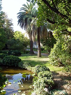
The Bantia Botanical Garden is a botanical garden in Burkina Faso, consisting of an area of Sudanian Savanna, protected from human impact and fire and enriched by local plant species. It was founded in the year 2001. [1]

Botanical garden well-tended area displaying a wide range of plants labelled with their botanical names

A botanical garden or botanic garden is a garden dedicated to the collection, cultivation, preservation and display of a wide range of plants labelled with their botanical names. It may contain specialist plant collections such as cacti and other succulent plants, herb gardens, plants from particular parts of the world, and so on; there may be greenhouses, shadehouses, again with special collections such as tropical plants, alpine plants, or other exotic plants. Visitor services at a botanical garden might include tours, educational displays, art exhibitions, book rooms, open-air theatrical and musical performances, and other entertainment.

Burkina Faso country in Africa

Burkina Faso is a landlocked country in West Africa. It covers an area of around 274,200 square kilometres (105,900 sq mi) and is surrounded by six countries: Mali to the north; Niger to the east; Benin to the southeast; Togo and Ghana to the south; and Ivory Coast to the southwest. The July 2018 population estimate by the United Nations was 19,751,651. Burkina Faso is a francophone country, with French as the official language of government and business. Roughly 40% of the population speaks the Mossi language. Formerly called the Republic of Upper Volta (1958–1984), the country was renamed "Burkina Faso" on 4 August 1984 by then-President Thomas Sankara. Its citizens are known as Burkinabé. Its capital is Ouagadougou.

Sudanian Savanna

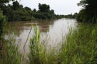
The Sudanian Savanna is a broad belt of tropical savanna that runs east and west across the African continent, from the Atlantic Ocean in the west to the western lowlands in the east. The Sahel, a belt of drier grasslands and acacia savannas, lies to the north, between the Sudanian Savanna and the Sahara Desert. To the south the forest-savanna mosaic is a transition zone between the Sudanian Savanna and the Guinean moist forests and Congolian forests that lie nearer the equator.

Situated c. 10 km south of the city Fada N’Gourma at the road towards Pama, it has an area of approximately 10 ha. Paths lead to the different habitats and to a central rest area. Furthermore, the garden includes a small museum and a guest house consisting of several rondavels.

Pama, Burkina Faso Place in Burkina Faso

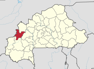
Pama is a town located in the province of Kompienga in Burkina Faso. It is the capital of Kompienga Province.

The garden is home to 116 species of trees and 110 species of herbs. [1]

Related Research Articles

Ouagadougou City in Centre Region, Burkina Faso

Ouagadougou, also Vagaga, is the capital of Burkina Faso and the administrative, communications, cultural, and economic centre of the nation. It is also the country's largest city, with a population of 2,200,000 in 2015. The city's name is often shortened to Ouaga. The inhabitants are called ouagalais. The spelling of the name Ouagadougou is derived from the French orthography common in former French African colonies.

Fada Ngourma City in Est Region, Burkina Faso

Fada N'gourma, also written Fada-Ngourma, or Noungu is a city and an important market town in eastern Burkina Faso, lying 219 kilometres (136 mi) east of Ouagadougou, in the Gourmantché area. It is the capital of the East region and of Gourma province. It is known for its blanket and carpet manufacturing as well as its honey.

Yatenga Province Province in Nord Region, Burkina Faso

Yatenga is one of the provinces of Burkina Faso, located in the Nord Region of the country. In modern Yatenga, the most prominent city is Ouahigouya. This city served as the capital of the kingdom of Yatenga, a powerful kingdom out of the many Mossi kingdoms, but its influence decreased in the century following French colonisation. The city is famed today for being home to the Naba's compound and the tomb of Naba Kango.

Kossi Province Province in Boucle du Mouhoun, Burkina Faso

The Province de la Kossi lies in the western part of Burkina Faso and stretches to the border with Mali. It is in the Boucle du Mouhoun Region. The capital of Kossi is the town of Nouna, which has a mayor and high commissioner. The next largest town in Kossi is Djibasso, the last major town on the road from Nouna that heads west into Mali.

W National Park national park in West Africa around a meander in the River Niger shaped like the letter W

The W National Park or W Regional Park is a major national park in West Africa around a meander in the River Niger shaped like the letter W. The park includes areas of the three countries Niger, Benin and Burkina Faso, and is governed by the three governments. Until 2008, the implementation of a regional management was supported by the EU-funded project ECOPAS. The three national parks operate under the name W Transborder Park.

Balé Province Province in Boucle du Mouhoun, Burkina Faso

Balé is one of the 45 provinces of Burkina Faso, located in its Boucle du Mouhoun Region with Boromo as capital. Its area is 4,595 km2 (1,774 sq mi), and in 2006 had a population of 213,897. The province is known for its Deux Balé Forest, populated by savannah elephant herds. Boromo, the provincial capital, is located on the main road from Ouagadougou to Bobo-Dioulasso. In June 2007, the Canadian mining company, Semafo, open the third gold mine in the country in Mana in the province, with an investment of about $116 million.

Banwa Province Province in Boucle du Mouhoun, Burkina Faso

Banwa is one of the 45 provinces of Burkina Faso and is in Boucle du Mouhoun Region. The capital of Banwa is Solenzo. In 2006 it had a population of 267,934.

Bazèga Province Province in Centre-Sud Region, Burkina Faso

Bazèga is one of the 45 provinces of Burkina Faso and is in Centre-Sud Region. The capital of Bazèga is Kombissiri. In 2006 the population of Bazèga was 238,202 and in 2011 it was estimated to be 263,603.

Boulkiemdé Province Province in Centre-Ouest Region, Burkina Faso

Boulkiemdé is one of the 45 provinces of Burkina Faso and is in Centre-Ouest Region. The capital of Boulkiemdé is Koudougou. The population of Boulkiemdé was 498,008 in 2006 and 567,680 in 2011.

Kouritenga Province Province in Centre-Est Region, Burkina Faso

Kouritenga, sometimes spelt Kourittenga, is one of the 45 provinces of Burkina Faso, located in its Centre-Est Region. In 2006 the province had a population of 330,342. Its capital is Koupéla.

Mouhoun Province Province in Boucle du Mouhoun, Burkina Faso

Mouhoun is one of the 45 provinces of Burkina Faso and is in Boucle du Mouhoun Region. The capital of Mouhoun is Dédougou.

Nayala Province Province in Boucle du Mouhoun, Burkina Faso

Nayala is one of the 45 provinces of Burkina Faso and is in Boucle du Mouhoun Region.

Passoré Province Province in Nord Region, Burkina Faso

Passoré is one of the 45 provinces of Burkina Faso, located in its Nord Region. Its capital is Yako.

Sanguié Province Province in Centre-Ouest Region, Burkina Faso

Sanguié is one of the 45 provinces of Burkina Faso, located in its Centre-Ouest Region. In 2006 the population was 297,230. Its capital is Réo.

Zorgho Place in Plateau-Central Region, Burkina Faso

Zorgho is a town in the Zorgho Department of Ganzourgou Province in Burkina Faso. Zorgho is the capital of Zorgho Department and Ganzourgou Province and has a population of 21,518.

<i>Basilicum</i> genus of plants

Basilicum is a genus of plants in the Lamiaceae, first described in 1802. It contains only one known species, Basilicum polystachyon, native to Africa, Madagascar, southern Asia, New Guinea, Australia, and various islands of the Pacific and Indian Oceans.

Mount Tenakourou mountain

Mount Tenakourou is the highest point in Burkina Faso. It is a hill situated on the border of the Cascades Region of Burkina Faso and the Sikasso Region of the country of Mali, not far from the source of the Black Volta. It has an elevation of 747 metres (2,451 ft). The hill is part of Burkina Faso's South-Western sandstone massif and was formed through the incline of the country's Central Plateau. The surrounding terrain is relatively flat and around 400 metres (1,312 ft) high.

Namoungou is a village in the Piéla Department of Gnagna Province in eastern Burkina Faso. The village has a population of 497.

Burkinabe nationality law

Burkinabé nationality law is the body of law concerning who is a citizen of Burkina Faso. The basis of Burkinabé nationality law is Aatu no. An VII 0013/fP/PreS du 16 novembre 1989, portant institution et application du Code des personnes et de la famille.

References

  1. 1 2 CILSS (2012) Protéger et restaurer la terre pour mieux vivre: Les paysans de la region Est du Burkina Faso utilisent leur savoir et savoir-faire. 56 S.

Coordinates: 12°0.138′N0°23.079′E / 12.002300°N 0.384650°E / 12.002300; 0.384650

Geographic coordinate system Coordinate system

A geographic coordinate system is a coordinate system that enables every location on Earth to be specified by a set of numbers, letters or symbols. The coordinates are often chosen such that one of the numbers represents a vertical position and two or three of the numbers represent a horizontal position; alternatively, a geographic position may be expressed in a combined three-dimensional Cartesian vector. A common choice of coordinates is latitude, longitude and elevation. To specify a location on a plane requires a map projection.