
The Barents Sea is a marginal sea of the Arctic Ocean, located off the northern coasts of Norway and Russia and divided between Norwegian and Russian territorial waters. It was known earlier among Russians as the Northern Sea, Pomorsky Sea or Murman Sea ; the current name of the sea is after the historical Dutch navigator Willem Barentsz.
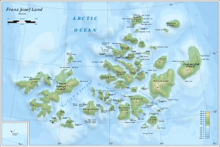
Franz Josef Land is a Russian archipelago in the Arctic Ocean. It is inhabited only by military personnel. It constitutes the northernmost part of Arkhangelsk Oblast and consists of 192 islands, which cover an area of 16,134 square kilometers (6,229 sq mi), stretching 375 kilometers (233 mi) from east to west and 234 kilometers (145 mi) from north to south. The islands are categorized in three groups separated by the British Channel and the Austrian Strait. The central group is further divided into a northern and southern section by the Markham Sound. The largest island is Prince George Land, which measures 2,741 square kilometers (1,058 sq mi), followed by Wilczek Land, Graham Bell Island and Alexandra Land.
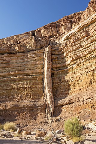
In geology, a dike or dyke is a sheet of rock that is formed in a fracture of a pre-existing rock body. Dikes can be either magmatic or sedimentary in origin. Magmatic dikes form when magma flows into a crack then solidifies as a sheet intrusion, either cutting across layers of rock or through a contiguous mass of rock. Clastic dikes are formed when sediment fills a pre-existing crack.

Diabase, also called dolerite or microgabbro, is a mafic, holocrystalline, subvolcanic rock equivalent to volcanic basalt or plutonic gabbro. Diabase dikes and sills are typically shallow intrusive bodies and often exhibit fine-grained to aphanitic chilled margins which may contain tachylite.

In geology, a sill is a tabular sheet intrusion that has intruded between older layers of sedimentary rock, beds of volcanic lava or tuff, or along the direction of foliation in metamorphic rock. A sill is a concordant intrusive sheet, meaning that it does not cut across preexisting rock beds. Stacking of sills builds a sill complex and a large magma chamber at high magma flux. In contrast, a dike is a discordant intrusive sheet, which does cut across older rocks.

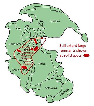
A large igneous province (LIP) is an extremely large accumulation of igneous rocks, including intrusive and extrusive, arising when magma travels through the crust towards the surface. The formation of LIPs is variously attributed to mantle plumes or to processes associated with divergent plate tectonics. The formation of some of the LIPs in the past 500 million years coincide in time with mass extinctions and rapid climatic changes, which has led to numerous hypotheses about causal relationships. LIPs are fundamentally different from any other currently active volcanoes or volcanic systems.
The Nevadan orogeny occurred along the western margin of North America during the Late Jurassic to Early Cretaceous approximately 155 Ma to 145 Ma. Throughout the duration of this orogeny there were at least two different kinds of orogenic processes occurring. During the early stages of orogenesis an "Andean type" continental magmatic arc developed due to subduction of the Farallon oceanic plate beneath the North American Plate. The latter stages of orogenesis, in contrast, saw multiple oceanic arc terranes accreted onto the western margin of North America in a "Cordilleran type" accretionary orogen. Deformation related to the accretion of these volcanic arc terranes is mostly limited to the western regions of the resulting mountain ranges and is absent from the eastern regions. In addition, the deformation experienced in these mountain ranges is mostly due to the Nevadan orogeny and not other external events such as the more recent Sevier and Laramide Orogenies. It is noted that the Klamath Mountains and the Sierra Nevada share similar stratigraphy indicating that they were both formed by the Nevadan orogeny. In comparison with other orogenic events, it appears that the Nevadan Orogeny occurred rather quickly taking only about 10 million years as compared to hundreds of millions of years for other orogenies around the world.
The Central Atlantic magmatic province (CAMP) is the Earth's largest continental large igneous province, covering an area of roughly 11 million km2. It is composed mainly of basalt that formed before Pangaea broke up in the Mesozoic Era, near the end of the Triassic and the beginning of the Jurassic periods. The subsequent breakup of Pangaea created the Atlantic Ocean, but the massive igneous upwelling provided a legacy of basaltic dikes, sills, and lavas now spread over a vast area around the present central North Atlantic Ocean, including large deposits in northwest Africa, southwest Europe, as well as northeast South America and southeast North America. The name and CAMP acronym were proposed by Andrea Marzoli and adopted at a symposium held at the 1999 Spring Meeting of the American Geophysical Union.
The High Arctic Large Igneous Province (HALIP) is a Cretaceous large igneous province in the Arctic. The region is divided into several smaller magmatic provinces. Svalbard, Franz Josef Land, Sverdrup Basin, Amerasian Basin, and northern Greenland are some of the larger divisions. Today, HALIP covers an area greater than 1,000,000 km2 (390,000 sq mi), making it one of the largest and most intense magmatic complexes on the planet. However, eroded volcanic sediments in sedimentary strata in Svalbard and Franz Josef Land suggest that an extremely large portion of HALIP volcanics have already been eroded away.

A dike swarm or dyke swarm is a large geological structure consisting of a major group of parallel, linear, or radially oriented magmatic dikes intruded within continental crust or central volcanoes in rift zones. Examples exist in Iceland and near other large volcanoes, around the world. They consist of several to hundreds of dikes emplaced more or less contemporaneously during a single intrusive event, are magmatic and stratigraphic, and may form a large igneous province.

The North Atlantic Igneous Province (NAIP) is a large igneous province in the North Atlantic, centered on Iceland. In the Paleogene, the province formed the Thulean Plateau, a large basaltic lava plain, which extended over at least 1.3 million km2 (500 thousand sq mi) in area and 6.6 million km3 (1.6 million cu mi) in volume. The plateau was broken up during the opening of the North Atlantic Ocean leaving remnants preserved in north Ireland, west Scotland, the Faroe Islands, northwest Iceland, east Greenland, western Norway and many of the islands located in the north eastern portion of the North Atlantic Ocean. The igneous province is the origin of the Giant's Causeway and Fingal's Cave. The province is also known as Brito–Arctic province and the portion of the province in the British Isles is also called the British Tertiary Volcanic Province or British Tertiary Igneous Province.

The Franklin Large Igneous Province is a Neoproterozoic large igneous province in the Canadian Arctic of Northern Canada. It represents one of the largest large igneous provinces in Canada, consisting of the Natkusiak flood basalts on Victoria Island, the Coronation sills on the southern shore of the Coronation Gulf and the large Franklin dike swarm, which extends for more than 1,200 km (750 mi) across the Canadian Arctic Archipelago and northwestern Greenland. The Franklin Large Igneous Province covers an area of more than 1,100,000 km2 (420,000 sq mi) and erupted more than 700 million years ago over the course of about two million years. Sulfur emissions during the eruption and weathering of the new rock following it may have contributed to a snowball earth event known as the Sturtian glaciation.
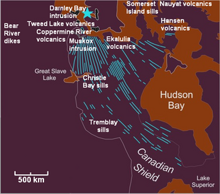
The Mackenzie Large Igneous Province (MLIP) is a major Mesoproterozoic large igneous province of the southwestern, western and northwestern Canadian Shield in Canada. It consists of a group of related igneous rocks that were formed during a massive igneous event starting about 1,270 million years ago. The large igneous province extends from the Arctic in Nunavut to near the Great Lakes in Northwestern Ontario where it meets with the smaller Matachewan dike swarm. Included in the Mackenzie Large Igneous Province are the large Muskox layered intrusion, the Coppermine River flood basalt sequence and the massive northwesterly trending Mackenzie dike swarm.
The Long Range dikes are a Neoproterozoic mafic dike swarm of Newfoundland and Labrador, Canada. It consists of a large igneous province with an area of 105,000 km2 (41,000 sq mi) that was constructed about 620 million years ago when Laurentia broke-up from Baltica. Its formation might have occurred when the ancient Iapetus Ocean began to open.
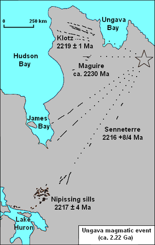
The Nipissing sills, also called the Nipissing diabase, is a large 2217– to 2210–million year old group of sills in the Superior craton of the Canadian Shield in Ontario, Canada, which intrude the Huronian Supergroup. Nipissing sills intrude all the Huronian sediments and older basement rocks in the northern margin of the Sudbury Basin; they were emplaced after the faulting and folding of Huronian rocks, and are hornblende gabbro of tholeiitic basalt composition. In the Sudbury–Elliot Lake area the Nipissing diabase is deformed; outcrops are parallel to the fold axes of the Huronian sedimentary rocks. Nipissing diabase intrusions are east-northeast trending and are no wider than 460 m (1,510 ft).
The Barents Basin or East Barents Basin is a sedimentary basin underlying the eastern half of the Barents Sea. Lying off Russia on the continental shelf between the Kola Peninsula and Novaya Zemlya, it produces oil and gas.

The Queen Victoria Sea is a body of water in the Arctic Ocean, stretching from northeast of Svalbard to northwest Franz Josef Land. It is obstructed by ice most of the year.

The Okavango Dyke Swarm is a giant dyke swarm of the Karoo Large Igneous Province in northeast Botswana, southern Africa. It consists of a group of Proterozoic and Jurassic dykes, trending east-southeast across Botswana, spanning a region nearly 2,000 kilometres (1,200 mi) long and 110 kilometres (68 mi) wide. The Jurassic dykes were formed approximately 179 million years ago, composed of mainly tholeiitic mafic rocks. The formation is related to the magmatism at the Karoo triple junction, induced by the plate tectonic break up of the Gondwana supercontinent in the early Jurassic.
The geology of Nigeria formed beginning in the Archean and Proterozoic eons of the Precambrian. The country forms the Nigerian Province and more than half of its surface is igneous and metamorphic crystalline basement rock from the Precambrian. Between 2.9 billion and 500 million years ago, Nigeria was affected by three major orogeny mountain-building events and related igneous intrusions. Following the Pan-African orogeny, in the Cambrian at the time that multi-cellular life proliferated, Nigeria began to experience regional sedimentation and witnessed new igneous intrusions. By the Cretaceous period of the late Mesozoic, massive sedimentation was underway in different basins, due to a large marine transgression. By the Eocene, in the Cenozoic, the region returned to terrestrial conditions.

The Drakensberg Group is a geological group named after the Drakensberg mountain range where in its uppermost sections the rocks are found. The Drakensberg Group lies over most of Lesotho and localities in the Eastern Cape, KwaZulu-Natal, and Free State provinces of South Africa. It forms part of the greater Karoo Igneous Province, which occurs over an extensive area of southern Africa.
