The Wallabi Group is the northern-most group of islands in the Houtman Abrolhos. Nominally located at 28°28′S113°42′E, it is 58 kilometres from the Australian mainland, and about 9 kilometres from the Easter Group.
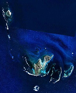
The Big Breaker is the most northerly geographic feature in the Houtman Abrolhos islands in the Indian Ocean off the west coast of Australia. It is located at the extreme tip of a reef that extends about three kilometres north of North Island. Its gazetted location is 28°15′56″S113°35′13″E, but in fact it is located about 270 metres south-east of there, at 28°16′00″S113°35′21″E. It is so named because it is a breaker, a portion of submerged reef over which waves break.
Suda Bay Passage is a channel through reef just north of North Island in the Houtman Abrolhos. Located at 28°17′29″S113°36′35″E, it is named after the Suda Bay, which was used for lobster fishing around North Island in the late 1940s.
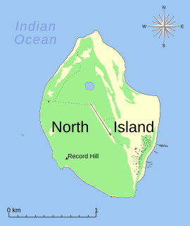
Record Hill is the highest hill on North Island in the Houtman Abrolhos. It is located in the southwest of the island; its gazetted location is 28°18′19″S113°35′29″E, but in fact it is located about 150 metres north of there at 28°18′15″S113°35′29″E. It is about 13 metres (42 ft) high.
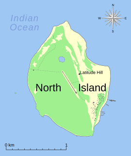
Latitude Hill is a hill on North Island in the Houtman Abrolhos. It is located in the east of the island. at 28°18′4″S113°35′59″E.
South Passage is a 14 kilometre (9 mi) wide strait that separates the outlying North Island from other islands in the Wallabi Group of the Houtman Abrolhos island chain, in the Indian Ocean off the coast of Western Australia. It is nominally located at 28°21′14″S113°35′46″E.

Arroz is an unincorporated community in Yolo County, California. It is located on the Southern Pacific Railroad 4 miles (6.4 km) south of Madison, at an elevation of 161 feet.

Obrowo is a village in the administrative district of Gmina Czarna Dąbrówka, within Bytów County, Pomeranian Voivodeship, in northern Poland. It lies approximately 11 kilometres (7 mi) south of Czarna Dąbrówka, 16 km (10 mi) north-east of Bytów, and 69 km (43 mi) west of the regional capital Gdańsk.
Lipa is a village in the administrative district of Gmina Stryków, within Zgierz County, Łódź Voivodeship, in central Poland. It lies approximately 3 kilometres (2 mi) north-west of Stryków, 15 km (9 mi) north-east of Zgierz, and 18 km (11 mi) north-east of the regional capital Łódź.
Wysoki Małe is a village in the administrative district of Gmina Bogoria, within Staszów County, Świętokrzyskie Voivodeship, in south-central Poland. It lies approximately 5 kilometres (3 mi) east of Bogoria, 15 km (9 mi) north-east of Staszów, and 56 km (35 mi) south-east of the regional capital Kielce.
Dzierżążno, is a village in the administrative district of Gmina Kartuzy, within Kartuzy County, Pomeranian Voivodeship, in northern Poland. It lies approximately 5 kilometres (3 mi) south-east of Kartuzy and 25 km (16 mi) west of the regional capital Gdańsk.
Lipowiec is a village in the administrative district of Gmina Chmielno, within Kartuzy County, Pomeranian Voivodeship, in northern Poland. It lies approximately 4 kilometres (2 mi) west of Chmielno, 10 km (6 mi) west of Kartuzy, and 38 km (24 mi) west of the regional capital Gdańsk.
Szklana is a village in the administrative district of Gmina Sierakowice, within Kartuzy County, Pomeranian Voivodeship, in northern Poland. It lies approximately 5 kilometres (3 mi) south-east of Sierakowice, 17 km (11 mi) west of Kartuzy, and 46 km (29 mi) west of the regional capital Gdańsk.
Hermanowo is a village in the administrative district of Gmina Gardeja, within Kwidzyn County, Pomeranian Voivodeship, in northern Poland. It lies approximately 3 kilometres (2 mi) south-west of Gardeja, 16 km (10 mi) south of Kwidzyn, and 88 km (55 mi) south of the regional capital Gdańsk.
Wodukajmy is a village in the administrative district of Gmina Sępopol, within Bartoszyce County, Warmian-Masurian Voivodeship, in northern Poland, close to the border with the Kaliningrad Oblast of Russia. It lies approximately 7 kilometres (4 mi) north-west of Sępopol, 12 km (7 mi) north-east of Bartoszyce, and 66 km (41 mi) north-east of the regional capital Olsztyn.
Bromierz is a village in the administrative district of Gmina Nowogard, within Goleniów County, West Pomeranian Voivodeship, in north-western Poland. It lies approximately 9 kilometres (6 mi) south-east of Nowogard, 25 km (16 mi) east of Goleniów, and 45 km (28 mi) north-east of the regional capital Szczecin.

Lobendava is a village and municipality (obec) in Děčín District in the Ústí nad Labem Region of the Czech Republic. The municipality covers an area of 19.54 square kilometres (7.54 sq mi), and has a population of 334.

Tees is a hamlet in central Alberta, Canada within Lacombe County. It is located 1 kilometre (0.62 mi) north of Highway 12, approximately 40 kilometres (25 mi) northeast of Red Deer.
HVDC Tian–Guang is a bipolar 500 kV HVDC system used for transmitting power generated at Tianshengqiao Hydroelectric Plant to Guangzhou. HVDC Tian–Guan, which was built by Siemens and inaugurated in 2001 is capable of transmitting a maximum power of 1,800 MW.

Myingyi Kyun, also known as High Island, is a small island off the coast of Ayeyarwady Region, Burma.


