Barkley Dam

Last updated
Barkley Dam
USACE Barkley Lock and Dam.jpg
Country United States of America
Location Kentucky
Coordinates 37°01′14″N88°13′25″W / 37.0206°N 88.2235°W / 37.0206; -88.2235
Opening date1966
Dam and spillways
Impounds Cumberland River
Height (thalweg)157 ft (48 m)
Reservoir
Creates Lake Barkley
Lake Barkley Lock and Dam, impounding Lake Barkley USACE Barkley Lock and Dam.jpg
Lake Barkley Lock and Dam, impounding Lake Barkley

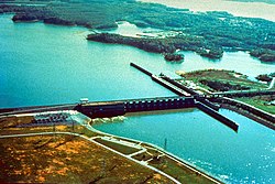
Barkley Dam is a dam along the Cumberland River in Kentucky. Its construction along with Kentucky Dam formed the Land Between the Lakes National Recreation Area (LBLNRA) by stopping the flow of the Cumberland and Tennessee Rivers, forming Lake Barkley and Kentucky Lake respectively. It is operated by the United States Army Corps of Engineers.

Barkley Dam is 157 feet (48 m) high and impounds a maximum of 2,082,000 acre-feet (2.6 cubic kilometers ). [1] Completed in 1966, the dam and artificial lake were both named for U.S. Vice President Alben Barkley.

Electricity from the dam is marketed by the Southeastern Power Administration. [2]

Related Research Articles

<span class="mw-page-title-main">Tennessee River</span> River in the southeastern United States

The Tennessee River is the largest tributary of the Ohio River. It is approximately 652 miles (1,049 km) long and is located in the southeastern United States in the Tennessee Valley. The river was once popularly known as the Cherokee River, among other names, as the Cherokee people had their homelands along its banks, especially in what are now East Tennessee and northern Alabama. Additionally, its tributary, the Little Tennessee River, flows into it from Western North Carolina and northeastern Georgia, where the river also was bordered by numerous Cherokee towns. Its current name is derived from the Cherokee town, Tanasi, which was located on the Tennessee side of the Appalachian Mountains.

<span class="mw-page-title-main">Cumberland River</span> River in Kentucky and Tennessee, United States

The Cumberland River is a major waterway of the Southern United States. The 688-mile-long (1,107 km) river drains almost 18,000 square miles (47,000 km2) of southern Kentucky and north-central Tennessee. The river flows generally west from a source in the Appalachian Mountains to its confluence with the Ohio River near Paducah, Kentucky, and the mouth of the Tennessee River. Major tributaries include the Obey, Caney Fork, Stones, and Red Rivers.

The Southeastern Power Administration is a United States Power Marketing Administration with responsibility for marketing hydroelectric power from 22 water projects operated by the U.S. Army Corps of Engineers in the states of West Virginia, Virginia, North Carolina, South Carolina, Georgia, Florida, Alabama, Mississippi, Tennessee and Kentucky.

<span class="mw-page-title-main">Lake Allatoona</span> Reservoir in Georgia, United States

Lake Allatoona is a U.S. Army Corps of Engineers reservoir on the Etowah River in northwestern part of the State of Georgia. This reservoir is mostly in southeastern Bartow County and southwestern Cherokee County. A small portion is located in Cobb County near Acworth.

<span class="mw-page-title-main">Lake Cumberland</span> Man-made lake in Kentucky, United States

Lake Cumberland is a reservoir in Clinton, Pulaski, Russell, Wayne, and Laurel, counties in Kentucky. The primary reasons for its construction were a means for flood control and the production of hydroelectric power. Its shoreline measures 1,255 miles (2,020 km) and the lake covers 65,530 acres (265 km2) at the maximum power pool elevation. The reservoir ranks 9th in the U.S. in size, with a capacity of 6,100,000 acre-feet (7.5 km3) of water, enough to cover the entire Commonwealth of Kentucky with 3 inches (76 mm) of water. The main lake is 101 miles (163 km) long and over one mile (1.6 km) across at its widest point.

<span class="mw-page-title-main">Lake Barkley</span>

Lake Barkley, a 58,000-acre (230 km2) reservoir in Livingston County, Lyon County and Trigg County in Kentucky and extending into Stewart County and Houston County in Tennessee, was impounded by the U.S. Army Corps of Engineers in 1966 upon the completion of Barkley Dam. Both the lake and the dam are named for Vice President Alben Barkley, a Kentucky native.

<span class="mw-page-title-main">Dale Hollow Reservoir</span> Reservoir in Tennessee and Kentucky, United States

The Dale Hollow Reservoir is a reservoir situated on the Kentucky/Tennessee border. The lake is formed by the damming of the Obey River, 7.3 miles (11.7 km) above its juncture with the Cumberland River at river mile 380. Portions of the lake also cover the Wolf River. Dale Hollow is one of four major flood control reservoirs for the Cumberland; the others being Percy Priest Lake, Lake Cumberland, and Center Hill Lake. It is also the site of Dale Hollow Lake State Park on the north (Kentucky) side.

<span class="mw-page-title-main">Center Hill Lake</span> Reservoir in Tennessee, United States

Center Hill Lake is a reservoir in the U.S. state of Tennessee. It is located in Middle Tennessee near Smithville. Created by means of a dam constructed by the U.S. Army Corps of Engineers in 1948, the lake has a dual purpose: electricity production and flood control. Center Hill Dam is 260 ft (79 m) high, and it is composed of concrete and earth structures, with 8 gates that are 50 ft (15 m) wide each. Center Hill Lake is one of four major flood control reservoirs for the Cumberland; the others being Percy Priest Lake, Dale Hollow Reservoir, and Lake Cumberland.

<span class="mw-page-title-main">Wolf Creek Dam</span> Dam in Russell County, Kentucky

The Wolf Creek Dam is a multi-purpose dam on the Cumberland River in the western part of Russell County, Kentucky, United States. The dam serves at once four distinct purposes: it generates hydroelectricity; it regulates and limits flooding; it releases stored water to permit year-round navigation on the lower Cumberland River; and it creates Lake Cumberland for recreation, the largest man made lake by volume East of the Mississippi river. The Lake has become a popular tourist attraction.U.S. Route 127 is built on top of the dam.

<span class="mw-page-title-main">J. Percy Priest Dam</span> Dam in Tennessee

J. Percy Priest Dam is a dam in north central Tennessee at river mile 6.8 of the Stones River, a tributary of the Cumberland. It is located about ten miles (16 km) east of downtown Nashville. The reservoir behind the dam is Percy Priest Lake. It is one of four major flood control reservoirs for the Cumberland; the others being Wolf Creek Dam, Dale Hollow Dam, and Center Hill Dam.

<span class="mw-page-title-main">Old Hickory Lock and Dam</span> Dam on the Cumberland River in Tennessee, United States

Old Hickory Lock and Dam is a dam located in middle Tennessee on the Cumberland River at river mile 216.2 in Sumner and Davidson Counties, approximately 25 miles (40 km) upstream from Nashville. The reservoir behind the dam is Old Hickory Lake. The dam and lake are named after President Andrew Jackson, who lived in the vicinity at The Hermitage.

<span class="mw-page-title-main">Libby Dam</span> Dam in Lincoln County, Montana

Libby Dam is a concrete gravity dam in the northwestern United States, on the Kootenai River in northwestern Montana. Dedicated on August 24, 1975, it is west of the continental divide, seventeen miles (27 km) upstream from the town of Libby.

<span class="mw-page-title-main">Carters Dam</span> Dam in Murray County, Georgia

Carters Dam is an earthen embankment dam located south of Chatsworth in Murray County and west of Ellijay in northwestern Georgia, United States, that creates Carters Lake.

<span class="mw-page-title-main">Philpott Dam</span>

<span class="mw-page-title-main">Hartwell Dam</span> Dam in Georgia, USA

Hartwell Dam is a concrete and embankment dam located on the Savannah River at the border of South Carolina and Georgia, creating Lake Hartwell. The dam was built by the U.S. Army Corps of Engineers between 1955 and 1962 for the purposes of flood control, hydropower and navigation. The concrete and earthen structure spans 15,840 feet (4,828 m). The concrete section is 1,900 feet (579 m) long and rises 204 feet (62 m) above the riverbed at its apex. The Hartwell Dam currently produces 468 million KWh of electricity annually, has prevented over $40 million in flood damage since completion and also provides recreation, water quality, water supply, along with fish and wildlife management.

<span class="mw-page-title-main">Kentucky Dam</span> Dam in Kentucky, United States

Kentucky Dam is a hydroelectric dam on the Tennessee River on the county line between Livingston and Marshall counties in the U.S. state of Kentucky. The dam is the lowermost of nine dams on the river owned and operated by the Tennessee Valley Authority, which built the dam in the late 1930s and early 1940s to improve navigation on the lower part of the river and reduce flooding on the lower Ohio and Mississippi rivers. It was a major project initiated during the New Deal of President Franklin D. Roosevelt's administration, to invest in infrastructure to benefit the country. The dam impounds the Kentucky Lake of 160,000 acres (65,000 ha), which is the largest of TVA's reservoirs and the largest artificial lake by area in the Eastern United States. It was designated as an National Historic Civil Engineering Landmark by the American Society of Civil Engineers in 1996 and listed on the National Register of Historic Places in 2017.

<span class="mw-page-title-main">Cordell Hull Lake</span> Reservoir in Tennessee, US

Cordell Hull Lake is a lake in the Cumberland River in north-central Tennessee, about forty miles east of Nashville, in the vicinity of Carthage. It covers approximately 12,000 acres (49 km2).

<span class="mw-page-title-main">Land Between the Lakes National Recreation Area</span> Protected area in Kentucky and Tennessee, U.S.

Land Between the Lakes National Recreation Area is a United States 171,280 acres (69,310 ha) national recreation area in Kentucky and Tennessee between Lake Barkley and Kentucky Lake. It was designated as a national recreation area in 1963 by President John F. Kennedy and developed using funds appropriated during the Johnson administration.

<span class="mw-page-title-main">Gravel Switch, Livingston County, Kentucky</span> Place in Kentucky, United States

Gravel Switch is an area along the Paducah & Louisville Railway (PAL) between the Kentucky Dam on the Tennessee River and Grand Rivers in Livingston County, Kentucky, United States near the interchange of U.S. Route 62 and Kentucky Route 453. The gravel of the area was prized as one of the best cementing gravels for the construction of railroad track ballast. It remains a rail, barge, and transloading terminal for aggregates for Vulcan Materials Company's Grand Rivers Quarry.

References

  1. "Barkley Dam (Lake Barkley)". Lakes Online. Archived from the original on 2016-03-04.
  2. "Generation – Southeastern Power Administration". Energy.gov. Retrieved 2023-03-20.