The Satpura Range is a range of hills in central India. The range rises in eastern Gujarat running east through the border of Maharashtra and Madhya Pradesh and ends in Chhattisgarh. The range parallels the Vindhya Range to the north, and these two east–west ranges divide Indian Subcontinent into the Indo-Gangetic plain of northern India and the Deccan Plateau of the south. The Narmada River originates from north-eastern end of Satpura in Amarkantak, and runs in the depression between the Satpura and Vindhya ranges, draining the northern slope of the Satpura range, running west towards the Arabian Sea. The Tapti River originates in the eastern-central part of Satpura, crossing the range in the center and running west at the range's southern slopes before meeting the Arabian Sea at Surat, draining the central and southern slopes of the range. Multai, the place of Tapti river origin is located about 465 kilometer far, south-westerly to Amarkantak, separated across by the hill range. The Godavari River and its tributaries drain the Deccan plateau, which lies south of the range, and the Mahanadi River drains the easternmost portion of the range. The Godavari and Mahanadi rivers flow into the Bay of Bengal. At its eastern end, the Satpura range meets the hills of the Chotanagpur Plateau. The Satpura Range is a horst mountain and is flanked by Narmada Graben in the north and much smaller but parallel Tapi Graben in the south.

Gir National Park and Wildlife Sanctuary, also known as Sasan Gir, is a forest, national park, and wildlife sanctuary near Talala Gir in Gujarat, India. It is located 43 km (27 mi) north-east of Somnath, 65 km (40 mi) south-east of Junagadh and 60 km (37 mi) south-west of Amreli. It was established in 1965 in the erstwhile Nawab of Junagarh's private hunting area, with a total area of 1,410.30 km2 (544.52 sq mi), of which 258.71 km2 (99.89 sq mi) is fully protected as a national park and 1,151.59 km2 (444.63 sq mi) as wildlife sanctuary. It is part of the Khathiar-Gir dry deciduous forests ecoregion.
Indravati National Park is a national park located in Bijapur district of Chhattisgarh state in India. The park derives its name from the Indravati River, which flows from east to west and forms the northern boundary of the reserve with the Indian state of Maharashtra.

The Upper Gangetic Plains moist deciduous forests is a tropical and subtropical moist broadleaf forests ecoregion of northern India.

The Northern dry deciduous forests, presently known as the North Deccan dry deciduous forests, is a tropical dry broadleaf forest ecoregion of east-central India.

Uttar Pradesh is India's fourth largest state by land area along with India's most populous state. It is located in the north-central part of the country. Much of the state is flat, low-lying plains suitable for rice farming. The only hills are in the southern border and northern border, the foothills of the Himalayas. The climate of this state can also vary widely - primarily due to it being far from the moderating effect of the sea, the occasional cold air arising due to western disturbances., and the Himalayas in the north trapping air flow.

Bhadra Wildlife Sanctuary is a protected area and tiger reserve as part of the Project Tiger, situated in Chikkamagaluru district, 23 km (14 mi) south of Bhadravathi city, 38 km (24 mi) 20 km from Tarikere town, northwest of Chikkamagaluru and 283 km from Bengaluru city in Karnataka state, India. Bhadra sanctuary has a wide range of flora and fauna and is a popular place for day outings. The 1,875 m (6,152 ft) above MSL Hebbe Giri is the highest peak in the sanctuary.

Kaundinya Wildlife Sanctuary is a wildlife sanctuary and an elephant reserve situated in Andhra Pradesh, India. It is the only sanctuary in Andhra Pradesh with a population of Asian elephants, which migrated after 200 years from neighbouring regions.

The Tadoba Andhari Tiger Reserve is a wildlife sanctuary in Chandrapur district of Maharashtra state in India. It is Maharashtra's oldest and largest national park. Created in 1955, the reserve includes the Tadoba National Park and the Andhari Wildlife Sanctuary. The reserve consists of 577.96 square kilometres (223.15 sq mi) of reserved forest and 32.51 square kilometres (12.55 sq mi) of protected forest.

Melghat was among the first nine tiger reserves of India to be notified in 1973 under Project Tiger. It is located in the northern part of Amravati District of Maharashtra. Melghat Wildlife Sanctuary was declared as in 1985. The total area of the reserve is 2,768 square kilometres.

Sunabeda Wildlife Sanctuary is a wildlife sanctuary and a proposed tiger reserve located in the Nuapada district of Odisha, adjoining Chhattisgarh. It has a total area of 600 km2 (230 sq mi). The sanctuary harbours a great diversity of wildlife habitats, with a vast plateau, multiple valleys, gorges and magnificent waterfalls. The sanctuary forms the catchment area of the Jonk River, over which a dam has been constructed to facilitate irrigation. The Indra nullah and Udanti River lies to the south of the sanctuary. The important vegetation of the site comprises dry deciduous tropical forest.

The Chandra Prabha Wildlife Sanctuary, also known as Chandraprabha, is situated in Chandauli district of Uttar Pradesh state in central India. It is well endowed with beautiful picnic spots, dense forests, and scenic waterfalls like Rajdari, Devdari & Naugarh waterfall that attract tourists every year to its vicinity. Chandra Prabha Wildlife Sanctuary is situated about 70 kilometres from the historic city of Varanasi.

Eturnagaram Wildlife Sanctuary is a wildlife sanctuary located in Eturnagaram village in Mulugu district in Telangana, India. It is located 100 km (62 mi) from Warangal and 250 km (160 mi) from Hyderabad. It is a integrated tribal development town.

The Sita Mata Wildlife Sanctuary is a wildlife sanctuary situated in Pratapgarh and Chittaurgarh districts of Rajasthan Rajasthan, India, declared as a protected forest area by the Government of Rajasthan Notification No. F 11 (9) Revenue/8/79, dated 2/11/1979. It is a dense forest, with an area of 422.95 square kilometers, which is about 40% of the total land area of the district. The land is undulating because of the confluence of three different formations — Malwa Plateau, the Vindhyachal Hills and Aravali mountain ranges.

Nauradehi Wildlife Sanctuary, covering about 1,197 km2 (462 sq mi), is the largest wildlife sanctuary of Madhya Pradesh state in India. It is located in the centre of the state covering parts of Sagar, Damoh, Narsinghpur, and Raisen Districts. It is about 90 km from Jabalpur and about 56 km from Saugor.
Shoolpaneshwar Wildlife Sanctuary is a protected area in India's Gujarat state, located in the western Satpura Range south of the Narmada River and is 607.7 km2 (234.6 sq mi) large. It shares a common boundary with Madhya Pradesh and Maharashtra. It encompasses mixed dry deciduous forest, riverine forest, few pockets of moist teak forest, agricultural fields and two water reservoirs. It was established in 1982.
Gautala Autramghat Sanctuary is a protected area of Maharashtra state, India. It lies in the Satmala and Ajantha hill ranges of the Western Ghats, and administratively is in Aurangabad District and Jalgaon District. The wildlife sanctuary was established in 1986 in an existing reserved forest area.

Ghodazari Wildlife Sanctuary is a wildlife reserve established in 2018 in Nagbhir in the Chandrapur district of the Vidarbha region in Maharashtra, India. It includes 159 km2 (61 sq mi) of southern tropical dry forest and a lake. The forest is considered a key region on the connecting corridor for the tiger migration between the Tadoba Andhari Tiger Project and Umred Karhandala Wildlife Sanctuary. It is named after a village of the same name that is almost in the middle of the forest, about 2 km from the dam and the resort. In Marathi, ghoda means horse and zari means a place with a water spring.
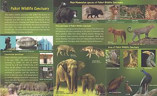
Palkot Wildlife Sanctuary is a wildlife sanctuary located near Palkot. It is spread over Gumla and Simdega districts of Jharkhand in India. The sanctuary cover total area of 182.83 km2 (70.59 sq mi).
Koderma Wildlife Sanctuary is located in the northern part of Koderma in the Koderma subdivision of the Koderma district in the state of Jharkhand, India.