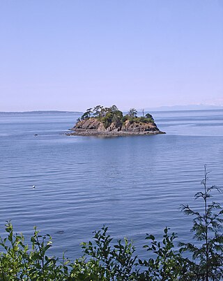
Barnes Island is a small (approx 34 acres, 0.053 sq miles) uninhabited island in San Juan County, Washington, USA. It is located near Clark Island off the northeast coast of Orcas Island. There is no ferry service to it, although it has a small dock. Barnes Island is a privately held island in the San Juans, owned by Charles Bundrandt as of 2013, and is being used for Christian camps, with a permanent group house in addition to tent sites.
The name was given by Charles Wilkes during the Wilkes Expedition of 1838–1842, to honor a sailor who was killed during the Battle of Lake Erie of the War of 1812. The island, along with nearby Clark Island, had been named in 1792 Islas de Aquays, by the Spanish explorer Francisco de Eliza, in honor of Eliza's patron the Viceroy of Mexico, Juan Vicente de Güemes, 2nd Count of Revillagigedo [1]

The San Juan Islands is an archipelago in the Pacific Northwest of the United States between the U.S. state of Washington and Vancouver Island, British Columbia, Canada. The San Juan Islands are part of Washington state, and form the core of San Juan County.

San Juan Island is the second-largest and most populous of the San Juan Islands in northwestern Washington, United States. It has a land area of 142.59 km2 and a population of 8,632 as of the 2020 census.

Fidalgo Island is an island in Skagit County, Washington, located about 60 mi (97 km) north of Seattle. To the east, it is separated from the mainland by the Swinomish Channel, and from Whidbey Island to the south by Deception Pass. The island is named after the Spanish explorer and cartographer Salvador Fidalgo, who explored the area in 1790.

Guemes Island is a small island in western Skagit County, Washington, United States. It is located north of Fidalgo Island and the city of Anacortes, and is accessible by private boat and by the Guemes Island ferry operated by Skagit County.

Blakely Island in San Juan County, Washington is the sixth largest island in the San Juan Islands of Washington State, United States, encompassing a land area of 16.852 km2. It is separated from Cypress Island to the east by Rosario Strait. The population was 56 persons as of the 2000 census.

Padilla Bay is a bay located in the U.S. state of Washington, between the San Juan Islands and the mainland. Fidalgo Island and Guemes Island lie to the west of Padilla Bay. Guemes Channel, between the islands, connects Padilla Bay to Rosario Strait. Samish Island lies to the north of Padilla Bay, beyond which is Samish Bay and Bellingham Bay.

Manuel Quimper Benítez del Pino was a Spanish Peruvian explorer, cartographer, naval officer, and colonial official. He participated in charting the Strait of Juan de Fuca and the Sandwich Islands in the late 18th century. He was later appointed a colonial governor in his native Peru at the beginning of the fight for independence there. He retired to Spain, but was able to return to Peru where he served as a naval officer in the new republic and pursued a literary career, publishing over 20 books about his experiences before his death there in Lima.
Henry Island is one of the San Juan Islands of San Juan County, Washington, United States. It lies just off the northwest shore of San Juan Island. The small Pearl Island also lies between Henry Island and San Juan Island at its northern end. Just northwest of the northern tip of Henry Island lies Battleship Island, a State bird sanctuary. Except for Stuart Island, Henry Island is the westernmost of the San Juan Islands. It has a land area of 4.126 km2 and had a total of19 permanent residents as of the 2010 census.

Eliza Island is located in the western part of Bellingham Bay in the U.S. state of Washington. It lies just east of the southern part of Lummi Island, in Whatcom County. Eliza Island has a land area of 0.571 km2. Its population was ten persons as of the 2010 census.

Rosario Strait is a strait in northern Washington state, separating San Juan County and Skagit and Whatcom Counties. It extends from the Strait of Juan de Fuca about 23 kilometres (14 mi) north to the Strait of Georgia. The USGS defines its southern boundary as a line extending from Point Colville on Lopez Island to Rosario Head on Fidalgo Island, and its northern boundary as a line from Point Migley on Lummi Island to the east tip of Puffin Island and then to Point Thompson on Orcas Island. Rosario Strait runs north-south between Lopez, Decatur, Blakely, and Orcas Islands on the west, and Fidalgo, Cypress, Sinclair, and Lummi Islands on the east.

Saratoga Passage lies in Puget Sound between Whidbey Island and Camano Island.
Skull Island is the name of two small islands in the San Juan Archipelago in the U.S. state of Washington. The northernmost Skull Island is located off the coast of Orcas Island in Massacre Bay, the most northern extension of the island's West Sound. It is identified as 3.2-acre (1.3 ha) Skull Island State Park Property by the Washington State Parks and Recreation Commission. It was named for holding skulls and bones of a band of Lummi who were killed by raiding Haida in 1858. Since 2013, it has been part of the San Juan Islands National Monument.
The Wasp Islands are a group of small islands in the San Juan Islands of the U.S. state of Washington.
Turn Island is a 34-acre (14 ha) island in the San Juan Islands in the Salish Sea in the U.S. state of Washington. The island sits in the San Juan Channel about 900 feet off the east coast of San Juan Island. It is preserved as Turn Island Marine State Park and is part of the San Juan Islands National Wildlife Refuge. The island has 12 campsites and is only accessible by water.

Strawberry Island is a small island in Island County, Washington, United States. It is located just east of Deception Pass, which separates Fidalgo Island (N) from Whidbey Island (S).
O'Neal Island is a small island in the San Juan Islands of the U.S. state of Washington. It lies off the northeastern coast of San Juan Island.

Matia Island is an island in the San Juan Islands of the U.S. state of Washington. The island's entire 145 acres (59 ha) comes under the protection of the U.S. Fish and Wildlife Service and is cooperatively managed by the Washington State Parks and Recreation Commission as Matia Island Marine State Park. Matia Island is a National Wildlife Refuge, part of the San Juan Islands National Wildlife Refuge. A 2-acre (0.81 ha) camping area around Rolfe Cove is managed as a State Marine Park by the Washington State Parks and Recreation Commission under an agreement dating back to 1959. Pets, wood collecting, and campfires are not allowed on the island. Except for the Wilderness Loop Trail and the campground, all areas above the high tide line are closed to the public.
Frost Island is an island in the San Juan Islands of the U.S. state of Washington. The approximately 70-acre island has no public electric service or land-line telephone service. There is a water-taxi that runs between the island and Anacortes.
Freeman Island is a tiny island in the San Juan Islands of the U.S. state of Washington, west of Orcas Island. It is part of the San Juan Islands National Monument . The name was given by Charles Wilkes during the Wilkes Expedition of 1838–1842, originally as Freeman's Island, in honor of J.D. Freeman, the sailmaker of the expedition's Peacock.

Clark Island is an island in the San Juan Islands of the Pacific Northwest, located near Barnes Island off the northeast coast of Orcas Island. It is part of the U.S. state of Washington. Clark Island Marine State Park, which encompasses the entire 55-acre (22 ha) island, has two picnicking sites, 15 primitive campsites, and nine mooring buoys.
| | This San Juan County, Washington state location article is a stub. You can help Wikipedia by expanding it. |