
Annaberg is a former district in Saxony, Germany. It was bounded by the Czech Republic and the districts of Aue-Schwarzenberg, Stollberg and Mittlerer Erzgebirgskreis. Its colors are pink, green, and blue.
Aue-Schwarzenberg is a former district in Saxony, Germany. It was bounded by the Czech Republic and the districts of Vogtlandkreis, Zwickauer Land, Stollberg and Annaberg.

Eibenstock is a town in the Erzgebirgskreis, Saxony, Germany. It is situated in the western Ore Mountains, near the river Mulde.

Schwarzenberg is a town in the district of Erzgebirgskreis in Saxony’s Ore Mountains, near the German–Czech border. The town lies roughly 15 km southeast of Aue, and 35 km southwest of Chemnitz.

Johanngeorgenstadt is a mining town in Saxony’s Ore Mountains, 17 km south of Aue, and 27 km northwest of Karlovy Vary. It lies in the district of Erzgebirgskreis, on the border with the Czech Republic, is a state-recognized health resort (Erholungsort), and calls itself Stadt des Schwibbogens. Its population decline since the 1950s has been extremely severe, falling from 45,000 residents in 1953 to only about one twelfth of that now.

Scheibenberg is a town in the district of Erzgebirgskreis in Saxony in Germany. It is situated in the Ore Mountains, 8 km southwest of Annaberg-Buchholz, and 9 km east of Schwarzenberg.

Schlettau is a town in the district of Erzgebirgskreis, in Saxony in Germany. It is situated in the Ore Mountains, 5 km southwest of Annaberg-Buchholz, and 12 km east of Schwarzenberg.

The Knochen is a monadnock between the village of Raschau-Markersbach and the town of Schwarzenberg in the Saxon part of the Ore Mountains in southeastern Germany. Its summit lies 551.4 metres above sea level.

The Ore Mountain passes are crossings and passages over the crest of the Ore Mountains in Central Europe, over which tracks, roads, railway lines and pipelines run from the Free State of Saxony in the Federal Republic of Germany to Bohemia in the Czech Republic and vice versa.

The Eastern Ore Mountains form a natural region of Saxony that covers the eastern part of the Saxon Ore Mountains range. Together with the Western and Central Ore Mountains, it is part of the larger Saxon Highlands and Uplands region. Its southern continuation beyond the German border covers an area of roughly the same extent in the Czech Republic.

The Treaty of Eger, also called Main Compromise of Eger or Peace of Eger was concluded on 25 April 1459 in the Imperial City of Eger (Cheb), administrative seat of the immediate pawn of Egerland. The treaty established the border between the Kingdom of Bohemia and the Electorate of Saxony on the main ridge of the Ore Mountains stretching from Eger to the River Elbe. The border remains largely unchanged up to today, separating the Czech Republic and Germany, and is thus one of the oldest still extant borders in Europe.

The Kulmer Steig is a synonym for the transport links from the Elbe valley over the eastern part of the Eastern Ore Mountains to Bohemian Chlumec u Chabařovic, hence the name which means "Kulm Trail". It is an ancient road system of partly derelict and unmetalled historic transport routes. These historic long-distance routes have been uncovered today thanks to archaeological discoveries. The routes all head south from the Elbe valley between Dresden and Pirna and cross the Eastern Ore Mountains over mountain passes on the Saxon side between Fürstenwalde in the west and Oelsen in the east. The lowest crossings are located near Mohelnice from where they continue via Habartice and the Geiersberg as well as Krasný Les and further on over the Nollendorf Pass to Chlumec. The Kulmer Steig was an especially good transport route because the road cut a passage through untamed wilderness and 30 kilometres could be covered in a day.

Grünhain Abbey in Grünhain in the Saxon Ore Mountains, which was built and run by Cistercians, existed from 1230 to 1536. Today only its ruins remain.

The Miners' Parade is a parade traditionally held in places in Austria and Germany where ore was and is smelted. It was and is a public event held by a community or corporation whose employment is linked to mining and smelting. It is usually known in German as a Bergparade, but also as a Berg- und Hüttenparade. It takes place as one of the highlights of a festival. The Miner's Parade is a special form of procession which is organised to march past important dignitaries or which is organized for such high-ranking individuals.
The Saxon Mining Office is the executive authority for mining rights in the German state of Saxony. It is also responsible for all non-metallic mineral resources on the terrain of the former East Germany.

Myslivny is a locality within the territory of Boží Dar in the Czech Republic. It is formed by few scattered houses and the Myslivny Reservoir.
The Buchschachtelberg is a forested mountain south of Henneberg in the western Saxon Ore Mountains, which is 973 metres high. The border between Germany and the Czech Republic runs over its summit.
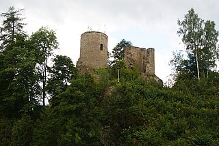
Lauterstein Castle, in German Burg Lauterstein, also called Burgruine Niederlauterstein, is a medieval castle in Niederlauterstein, town of Marienberg, Erzgebirgskreis, Saxony. It has been a ruin since the Thirty Years' War.

The Erla Ironworks has its origins in one of the oldest hammer mills in the Upper Ore Mountains, which was first recorded in 1380 as the Hammer in der Erl, making the ironworks the oldest existing business in the German state of Saxony.

Rittersgrün is a district of the municipality of Breitenbrunn/Erzgeb. in the Saxon Erzgebirge district. The scattered settlement with around 1600 inhabitants grew up around several hammer mills, which operated on the course of the Pöhlwasser from the 15th to the 19th century and were supplied with ore from numerous surrounding mines. Due to its location on an important Erzgebirge pass, the settlement was repeatedly plundered by passing mercenaries during the Thirty Years' War. After the decline of the hammer mill industry in the middle of the 19th century, the village's economy was dominated by cardboard and sawmills. In 2007, Rittersgrün was incorporated into Breitenbrunn/Erzgeb. Today, Rittersgrün is primarily known as an excursion and winter sports resort. The main attractions include the Saxon Narrow Gauge Railway Museum and a well-developed network of hiking trails.
