Related Research Articles

Mato Grosso is one of the states of Brazil, the third largest by area, located in the Central-West region. The state has 1.66% of the Brazilian population and is responsible for 1.9% of the Brazilian GDP.

Mato Grosso do Sul is one of the Midwestern states of Brazil. Neighboring Brazilian states are Mato Grosso, Goiás, Minas Gerais, São Paulo and Paraná. It also borders the countries of Paraguay, to the southwest, and Bolivia, to the west. The economy of the state is largely based on agriculture and cattle-raising. Crossed in the south by the Tropic of Capricorn, Mato Grosso do Sul generally has a warm, sometimes hot, and humid climate, and is crossed by numerous tributaries of the Paraná River. The state has 1.3% of the Brazilian population and is responsible for 1.5% of the Brazilian GDP.

Cáceres is a municipality in the Brazilian state of Mato Grosso. It covers an area of 24,000km2 and as of 2020 had an estimated population of 94,861.

The Pantanal is a natural region encompassing the world's largest tropical wetland area, and the world's largest flooded grasslands. It is located mostly within the Brazilian state of Mato Grosso do Sul, but it extends into Mato Grosso and portions of Bolivia and Paraguay. It sprawls over an area estimated at between 140,000 and 195,000 km2. Various subregional ecosystems exist, each with distinct hydrological, geological and ecological characteristics; up to 12 of them have been defined.
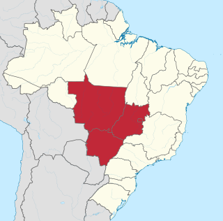
The Central-West or Center-West Region of Brazil is composed of the states of Goiás, Mato Grosso and Mato Grosso do Sul; along with Distrito Federal, where Brazil's national capital, Brasília, is situated. The region comprises 18.86% of the national territory.

Marshal Cândido Mariano da Silva Rondon was a Brazilian military officer most famous for his telegraph commission and exploration of Mato Grosso and the Western Amazon Basin, as well as his lifelong support for indigenous Brazilians. He was the first director of Brazil's Indian Protection Service or SPI and supported the creation of the Xingu National Park. The Brazilian state of Rondônia is named after him.
The Nambikwara is an indigenous people of Brazil, living in the Amazon. Currently about 1,200 Nambikwara live in indigenous territories in the Brazilian state of Mato Grosso along the Guaporé and Juruena rivers. Their villages are accessible from the Pan-American highway.

Sinop is a city in the Brazilian state of Mato Grosso. The fourth-largest city in the state, its population in 2020 is estimated at more than 199,680 inhabitants, placing Sinop in 229th place in Brazil. It has an area of 3194.339 km ². A Sivam radar has been installed for monitoring the Amazon Basin. Also Embrapa has a branch in Sinop, the only one in the state of Mato Grosso. It is known as the Capital of Nortão, a major city of northern Mato Grosso.

The Mato Grosso campaign was an early Paraguayan offensive in the Paraguayan War. Paraguay invaded the Brazilian province of Mato Grosso.

Time in Brazil is calculated using standard time, and the country is divided into four standard time zones: UTC−02:00, UTC−03:00, UTC−04:00 and UTC−05:00.

BR-163 is a highway in Brazil, going from Tenente Portela, in the state of Rio Grande do Sul, to Santarém, Pará, on 3579 kilometers .. It was proposed to pave the road in its entirety part of the Avança Brasil project, which in 2007 was replaced by the Programa de Aceleração do Crescimento. A 51 km long stretch of the highway was finally paved in 2019 in the state of Pará in a cooperation between the Bolsonaro government and the Brazilian army engineering battalion, until the city of Miritituba, leaving only a small part of the highway to be paved on the other side of the Amazon River.
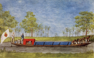
Alexandre Rodrigues Ferreira was a Portuguese naturalist born in Brazil. He undertook an extensive journey which crossed the interior of the Amazon Basin to Mato Grosso, between 1783 and 1792. During this journey, he described the agriculture, flora, fauna, and native inhabitants.
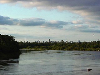
The Cuiabá River is a Brazilian river in the western state of Mato Grosso that flows in the Río de la Plata Basin. It is a tributary of the São Lourenço River.

The Nambikwaran languages are a language family of half a dozen languages, all spoken in the state of Mato Grosso in Brazil. They have traditionally been considered dialects of a single language, but at least three of them are mutually unintelligible.

The Ramarama languages of Rondônia, Brazil form a branch of the Tupian language family. They are Karo, or Ramarama, with 150 speakers, and the extinct Urumi.
The Arraias River is a river of Mato Grosso state in western Brazil.
Arara may refer to: