
Lake Parramatta is a heritage-listed man-made reservoir and a recreational area located in North Parramatta, City of Parramatta, in the Western Sydney region of New South Wales, Australia. The masonry arch-walled dam across Hunts Creek was completed in 1856 to supply water for domestic purposes; and was operational until 1909. The dam has since been decommissioned and the lake and the surrounding nature reserve are a popular recreational area.
Glennies Creek Dam is a minor ungated concrete faced curved earth and rockfill embankment dam with an uncontrolled rock cut spillway across the Glennies Creek, upstream of Singleton, in the Hunter region of New South Wales, Australia. The dam's purpose includes flood mitigation, irrigation, water supply and conservation. The impounded reservoir is called Lake Saint Clair.
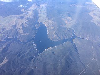
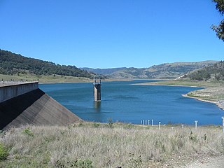
Burrinjuck Dam is a gated, concrete-walled hydro-electric gravity dam at Burrinjuck, in the South West Slopes region of New South Wales, Australia. It has three spillways across the Murrumbidgee River and forms an impounded reservoir called Lake Burrinjuck. In addition to electricity generation, Burrinjuck Dam is used for purposes including flood mitigation, irrigation, water supply and conservation. Also known as Barren Jack Dam and Barrenjack, it was added to the New South Wales State Heritage Register on 2 April 1999.

The Blowering Dam is a major ungated rock fill with clay core embankment dam with concrete chute spillway impounding a reservoir under the same name. It is located on the Tumut River upstream of Tumut in the Snowy Mountains region of New South Wales, Australia. Purposes for the dam include flood mitigation, hydro-power, irrigation, water supply and conservation. The dam is part of the Snowy Mountains Scheme, a vast hydroelectricity and irrigation complex constructed in south-east Australia between 1949 and 1974 and now run by Snowy Hydro.

The Upper Nepean Scheme is a series of dams and weirs in the catchments of the Cataract, Cordeaux, Avon and Nepean rivers of New South Wales, Australia. The scheme includes four dams and two weirs, and a gravity-fed canal system that feeds into a large storage reservoir to provide water to the Macarthur and Illawarra regions, the Wollondilly Shire, and metropolitan Sydney. The four dams and associated infrastructure are individually listed on the New South Wales State Heritage Register.

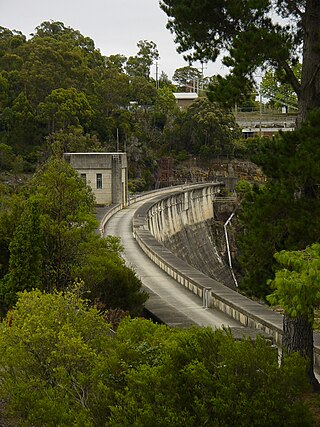
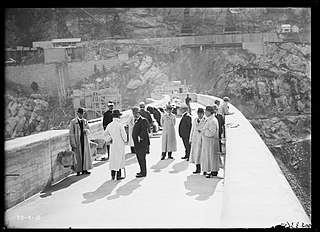
The Cataract Dam is a heritage-listed dam in Cataract, New South Wales, Australia, provides water to the Macarthur and Illawarra regions, the Wollondilly Shire, and metropolitan Sydney. It is one of four dams and weirs in the catchment of the Upper Nepean Scheme. Completed in 1907 under the supervision of Ernest Macartney de Burgh, the dam is currently owned by Water NSW, an agency of the Government of New South Wales. The dam was listed on the NSW State Heritage Register on 18 November 1999.
The Cordeaux Dam is a heritage-listed dam in Cordeaux, New South Wales, Australia. It provides water to the Macarthur and Illawarra regions, the Wollondilly Shire, and metropolitan Sydney. It is one of four dams and weirs in the catchment of the Upper Nepean Scheme. Completed in 1926 under the supervision of Ernest Macartney de Burgh, the dam is owned by Water NSW, an agency of the Government of New South Wales. It was listed on the New South Wales State Heritage Register on 18 November 1999.
The Nepean Dam is a heritage-listed dam split across Avon in the Wingecarribee Shire and Bargo in the Wollondilly Shire, both in New South Wales, Australia. The reservoir created by the dam spreads across Avon, Bargo and also Yerrinbool in Wingecarribee Shire. The Nepean Dam is one of four dams and weirs in the catchment of the Upper Nepean Scheme, in New South Wales, Australia, and provides water to the Macarthur and Illawarra regions, the Wollondilly Shire, and metropolitan Sydney. Completed in 1935 under the supervision of Ernest Macartney de Burgh, the dam is currently managed by the Sydney Catchment Authority and is listed on the New South Wales State Heritage Register.

The Avon Dam is a heritage-listed dam at Avon, in the New South Wales Southern Highlands, Australia. It is one of four dams and weirs in the catchment of the Upper Nepean Scheme, providing water to the Macarthur and Illawarra regions, the Wollondilly Shire, and metropolitan Sydney. The arch dam across the Avon River was completed in 1927 under the supervision of Ernest Macartney de Burgh, the dam is currently managed by the Sydney Catchment Authority and is listed on the New South Wales State Heritage Register.
The Blue Mountains Dams are a series of six dams in the Blue Mountains which supply water to the Blue Mountains and Sydney, Australia. The Dams are managed by the WaterNSW. Water in this scheme may be supplemented from the Fish River Scheme.

The Woronora Dam is a heritage-listed concrete gravity dam with an uncontrolled serpentine spillway across the Woronora River, located south of Greater Metropolitan Sydney, in the suburb of Woronora Dam, Sutherland Shire, New South Wales, Australia. The principal purpose of the dam is for potable water supply for Sydney's southern suburbs and the northern suburbs of the Illawarra region. The impounded 71,790-megalitre reservoir is also called Woronora Dam and is sometimes incorrectly called Lake Woronora. The dam was designed by G. E. Haskins, Chief Engineer and the Metropolitan Water, Sewerage and Drainage Board of NSW (MWS&DB) and built from 1927 to 1941 by the MWS&DB. The property is owned by the Sydney Catchment Authority, an agency of the Government of New South Wales. It was added to the New South Wales State Heritage Register on 18 November 1999.

The Prospect Reservoir is a heritage-listed 50,200-megalitre potable water supply and storage reservoir created by the Prospect Dam, across the Prospect Creek located in the Western Sydney suburb of Prospect, in New South Wales, Australia. The eastern bounds of the reservoir are a recreational area and the western periphery are within the bounds of Western Sydney Parklands. It was added to the New South Wales State Heritage Register on 18 November 1999.
Burrinjuck is a village community in the far eastern part of the Riverina, in the South West slopes of New South Wales. By road it is about 15 kilometres (9.3 mi) southwest of Woolgarlo and 28 kilometres (17 mi) south from Bookham. The name of the town is derived from an Aboriginal word meaning 'mountain with a rugged top'. At the 2016 census, the Burrinjuck area had a population of 19.

Spring Creek Dam is a minor embankment dam across the Spring Creek upstream of Orange in the central western region of New South Wales, Australia. The impounded reservoir is called the Spring Creek Reservoir.

Split Rock Dam is a minor ungated concrete faced rock fill embankment dam with concrete chute spillway across the Manilla River upstream of Manilla in the north-western slopes region of New South Wales, Australia. The dam's purpose includes flood mitigation, irrigation, water supply and conservation. The impounded reservoir is called Split Rock Reservoir.

The Taemas Bridge is a two-lane road bridge that carries the Wee Jasper Road across the Murrumbidgee River, at the settlement of Taemas, near Wee Jasper in the Yass Valley Council local government area of New South Wales, Australia. The bridge crosses on the river just before it enters Lake Burrinjuck, which has been created by the Burrinjuck Dam. The bridge is a key part of the road between Yass and Wee Jasper, and from there, to Tumut. The bridge is located approximately 26 kilometres (16 mi) from Yass and 22 kilometres (14 mi) from Wee Jasper. The property is owned by Transport for NSW. Under the Heritage Act, 1977 (NSW) s 170, the bridge was added to the New South Wales State agency heritage register on 18 August 2005.

The Manly Dam is a heritage-listed dam near King Street, Manly Vale with a reservoir extending into Allambie Heights, both in the Northern Beaches Council local government area of New South Wales, Australia. It is often used as a place to have recreational activities. The reservoir is located within the Manly Dam Reserve. The dam was designed by the NSW Department of Public Works and built in 1892 by the Department. The reservoir and dam is owned by Sydney Water, an agency of the Government of New South Wales. The reservoir and dam was added to the New South Wales State Heritage Register on 18 November 1999.
Greater Burrinjuck Dam Site is a heritage-listed dam surrounds at Burrinjuck, Yass Valley Shire, New South Wales, Australia. It is also known as Burrinjuck Dam Site and Barren Jack or Barrenjack. The property is owned by Department of Planning and Infrastructure. It was added to the New South Wales State Heritage Register on 2 April 1999.
Wooden Wicket, Berembed Weir is a heritage-listed wooden weir component at Berembed Weir, Murrumbidgee River, Matong, City of Wagga Wagga, New South Wales, Australia. It was made in 1910 at Fitzroy Dock in Sydney. It was added to the New South Wales State Heritage Register on 2 April 1999.

Medlow Dam is a heritage-listed major gated concrete-walled arch dam across the Adams Creek in the Blue Mountains region, located at Beauchamp Road, Medlow Bath in the City of Blue Mountains local government area of New South Wales, Australia. The dam was designed and built in 1907 by the NSW Department of Public Works. The dam's purpose is primarily for the potable water supply of the upper Blue Mountains region. The impounded reservoir is called Medlow Bath Reservoir. The dam is also known as Medlow Bath Dam, Lake Medlow Dam, Adams Creek Dam and Medlow Bath Reservoir. The property is owned by Sydney Water, a state-owned corporation of the Government of New South Wales. The dam was added to the New South Wales State Heritage Register on 18 November 1999.
