An esker, eskar, eschar, or os, sometimes called an asar, osar, or serpent kame, is a long, winding ridge of stratified sand and gravel, examples of which occur in glaciated and formerly glaciated regions of Europe and North America. Eskers are frequently several kilometres long and, because of their peculiar uniform shape, are somewhat like railway embankments.

The Appalachian Mountains, often called the Appalachians, are a system of mountains in eastern North America. The Appalachians first formed roughly 480 million years ago during the Ordovician Period. They once reached elevations similar to those of the Alps and the Rocky Mountains before experiencing natural erosion. The Appalachian chain is a barrier to east–west travel, as it forms a series of alternating ridgelines and valleys oriented in opposition to most highways and railroads running east–west.

The Great Valley, also called the Great Appalachian Valley or Great Valley Region, is one of the major landform features of eastern North America. It is a gigantic trough—a chain of valley lowlands—and the central feature of the Appalachian Mountain system. The trough stretches about 1,200 miles (1,900 km) from Quebec to Alabama and has been an important north-south route of travel since prehistoric times.

Barrier islands are coastal landforms and a type of dune system that are exceptionally flat or lumpy areas of sand that form by wave and tidal action parallel to the mainland coast. They usually occur in chains, consisting of anything from a few islands to more than a dozen. They are subject to change during storms and other action, but absorb energy and protect the coastlines and create areas of protected waters where wetlands may flourish. A barrier chain may extend uninterrupted for over a hundred kilometers, excepting the tidal inlets that separate the islands, the longest and widest being Padre Island of Texas. The length and width of barriers and overall morphology of barrier coasts are related to parameters including tidal range, wave energy, sediment supply, sea-level trends, and basement controls. The amount of vegetation on the barrier has a large impact on the height and evolution of the island.

In geography, a sound is a large sea or ocean inlet, deeper than a bight and wider than a fjord; or a narrow sea or ocean channel between two bodies of land.

The North Downs are a ridge of chalk hills in south east England that stretch from Farnham in Surrey to the White Cliffs of Dover in Kent. Westerham Heights, at the northern edge of the North Downs, near Bromley, South London, is the highest point in London at an elevation of 245 m (804 ft). The North Downs lie within two Areas of Outstanding Natural Beauty (AONBs), the Surrey Hills and the Kent Downs. The North Downs Way National Trail runs along the North Downs from Farnham to Dover.

The Blue Ridge Mountains are a physiographic province of the larger Appalachian Mountains range. The mountain range is located in the eastern United States, and extends 550 miles southwest from southern Pennsylvania through Maryland, West Virginia, Virginia, North Carolina, South Carolina, Tennessee, and Georgia. This province consists of northern and southern physiographic regions, which divide near the Roanoke River gap. To the west of the Blue Ridge, between it and the bulk of the Appalachians, lies the Great Appalachian Valley, bordered on the west by the Ridge and Valley province of the Appalachian range.

The Ridge-and-Valley Appalachians, also called the Ridge and Valley Province or the Valley and Ridge Appalachians, are a physiographic province of the larger Appalachian division and are also a belt within the Appalachian Mountains extending from southeastern New York through northwestern New Jersey, westward into Pennsylvania and southward into Maryland, West Virginia, Virginia, Kentucky, Tennessee, Georgia and Alabama. They form a broad arc between the Blue Ridge Mountains and the Appalachian Plateau physiographic province. They are characterized by long, even ridges, with long, continuous valleys in between.

A body of water or waterbody is any significant accumulation of water, generally on a planet's surface. The term most often refers to oceans, seas, and lakes, but it includes smaller pools of water such as ponds, wetlands, or more rarely, puddles. A body of water does not have to be still or contained; rivers, streams, canals, and other geographical features where water moves from one place to another are also considered bodies of water.
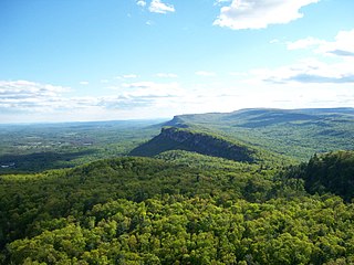
The Shawangunk Ridge, also known as the Shawangunk Mountains or The Gunks, is a ridge of bedrock in Ulster County, Sullivan County and Orange County in the state of New York, extending from the northernmost point of New Jersey to the Catskill Mountains. Shawangunk Ridge is the continuation of the long, easternmost ridge of the Appalachian Mountains; the ridge is known as Kittatinny Mountain in New Jersey, and as Blue Mountain as it continues through Pennsylvania. This ridge constitutes the western border of the Great Appalachian Valley.

A drainage divide, water divide, divide, ridgeline, watershed, water parting or height of land is elevated terrain that separates neighbouring drainage basins. On rugged land, the divide lies along topographical ridges, and may be in the form of a single range of hills or mountains, known as a dividing range. On flat terrain, especially where the ground is marshy, the divide may be harder to discern.

Watson's Dodd is a fell in the English Lake District, a minor rise on the main ridge of the Helvellyn range in the Eastern Fells, but a prominent shoulder on the west side of that range.

The Nittany Valley is an eroded anticlinal valley in the central portion of Centre County, Pennsylvania in the United States. It is separated from the Bald Eagle Valley by Bald Eagle Mountain and from Penns Valley by Mount Nittany. The valley is closed to the north by a high plateau that joins these two mountain ridges, but is open to the south at the southern terminus of Mount Nittany. The valley drains to the Bald Eagle Creek through water gaps in Bald Eagle Mountain formed by Spring Creek, and Fishing Creek, along with smaller streams running through Curtain Gap and Howard Gap. The Northwest side of the valley between the Bald Eagle Mountain ridge and the lower Sand Ridge is also known as the "Little Nittany Valley".

The Geology of Pennsylvania consists of six distinct physiographic provinces, three of which are subdivided into different sections. Each province has its own economic advantages and geologic hazards and plays an important role in shaping everyday life in the state. They are: the Atlantic Coastal Plain Province, the Piedmont Province, the New England Province, the Ridge and Valley Province, the Appalachian Plateau Province, and the Central Lowlands Province.
New Jersey is a very geologically and geographically diverse region in the United States' Middle Atlantic region, offering variety from the Appalachian Mountains and the Highlands in the state's northwest, to the Atlantic Coastal Plain region that encompasses both the Pine Barrens and the Jersey Shore. The state's geological features have impacted the course of settlement, development, commerce and industry over the past four centuries.
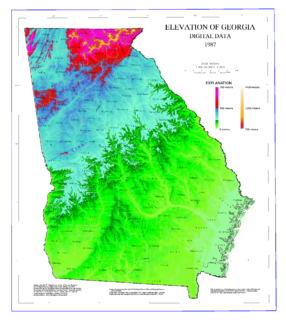
The geography of Georgia describes a state in the Southeastern United States in North America. The Golden Isles of Georgia lie off the coast of the state. The main geographical features include mountains such as the Ridge-and-valley Appalachians in the northwest, the Blue Ridge Mountains in the northeast, the Piedmont plateau in the central portion of the state and Coastal Plain in the south. The highest area in Georgia is Brasstown Bald which is 1,458 m (4,784 ft) above sea level, while the lowest is at sea level, at the Atlantic Ocean. Georgia is located at approximately 33° N 83.5° W. The state has a total area of 154,077 km2 (59,489 sq mi) and the geographic center is located in Twiggs County.

Pochuck Mountain is a ridge in the New York-New Jersey Highlands region of the Appalachian Mountains. Pochuck Mountain's summit and most of its peaks lie within Vernon Township, Sussex County, New Jersey, although the south-western portion of the ridge lies within Hardyston Township, and the north-eastern tip of the ridge extends over the New York state line into Orange County. The ridge marks the eastern edge of the Great Appalachian Valley, and it divides the watersheds of the Wallkill River and its tributary Pochuck Creek. The two rivers meet at Pochuck Neck, marking the terminus of the ridge.

The Marlboro Mountains, sometimes Marlborough Mountains, are a group of hogbacked mountains arranged in a 25-mile-long (40 km) ridge extending from Newburgh, New York to just south of Kingston, New York. Considered to be part of the Ridge and Valley Appalachians, the mountains, which reach elevations over 1,100 feet, form an imposing geologic barrier just west of the Hudson River. They subdivide the relatively flat Hudson River Valley to create the Wallkill Valley further west. Rising abruptly on their eastern flanks, the Marlboro Mountains are known for their sweeping views of the region.