Related Research Articles
San Antonio is a city in the U.S. state of Texas and the most populous city in Greater San Antonio, the third-largest metropolitan area in Texas and the 24th-largest metropolitan area in the United States at 2.6 million people in the 2020 US census. It is the most populous city in and the county seat of Bexar County. The city is the seventh-most populous in the United States, the second-largest in the Southern United States, and the second-most populous in Texas after Houston.

Tucson is a city in and the county seat of Pima County, Arizona, United States, and is home to the University of Arizona. It is the second-largest city in Arizona behind Phoenix, with a population of 542,629 in the 2020 United States census, while the population of the entire Tucson metropolitan statistical area (MSA) is 1,043,433. The Tucson MSA forms part of the larger Tucson-Nogales combined statistical area. Both Tucson and Phoenix anchor the Arizona Sun Corridor. The city is 108 miles (174 km) southeast of Phoenix and 60 mi (100 km) north of the United States–Mexico border.

Interstate 10 (I-10) is the southernmost transcontinental highway in the Interstate Highway System. I-10 is the fourth-longest Interstate in the United States at 2,460.34 miles (3,959.53 km), following I-90, I-80, and I-40. This freeway is part of the originally planned network that was laid out in 1956, and its last section was completed in 1990.

Pasadena is a city in Los Angeles County, California, United States, 11 miles (18 km) northeast of downtown Los Angeles. It is the most populous city and the primary cultural center of the San Gabriel Valley. Old Pasadena is the city's original commercial district.

The Arroyo Seco Parkway, also known as the Pasadena Freeway, is one of the oldest freeways in the United States. It connects Los Angeles with Pasadena alongside the Arroyo Seco seasonal river. Mostly opened in 1940, it represents the transitional phase between early parkways and later freeways. It conformed to modern standards when it was built, but is now regarded as a narrow, outdated roadway. A 1953 extension brought the south end to the Four Level Interchange in downtown Los Angeles and a connection with the rest of the freeway system.

Route 110, consisting of State Route 110 (SR 110) and Interstate 110 (I-110), is a state and auxiliary Interstate Highway in the Los Angeles metropolitan area of the US state of California. The entire route connects San Pedro and the Port of Los Angeles with Downtown Los Angeles and Pasadena. The southern segment from San Pedro to I-10 in downtown Los Angeles is signed as I-110, while the northern segment to Pasadena is signed as SR 110. The entire length of I-110, as well as SR 110 south of the Four Level Interchange with US Route 101 (US 101), is the Harbor Freeway, and SR 110 north from US 101 to Pasadena is the historic Arroyo Seco Parkway, the first freeway in the western United States.

Bidwell Mansion State Historic Park was a historic building with surrounding land in Chico, California, United States. It is listed as a California Historical Landmark #329 under the name "Rancho Chico And Bidwell Adobe" in 1939; and is listed on the National Register of Historic Places under the name "Bidwell Mansion" on March 24, 1972. On December 11, 2024, the building was destroyed in a fire.

Highland Park is a neighborhood in Los Angeles, California, located in the city's Northeast region. It was one of the first subdivisions of Los Angeles and is inhabited by a variety of ethnic and socioeconomic groups.

State Route 163 (SR 163), or the Cabrillo Freeway, is a state highway in San Diego, California. The 11.088-mile (17.844 km) stretch of the former US 395 freeway runs from downtown San Diego just south of an interchange with Interstate 5 (I-5), extending north through historic Balboa Park and various neighborhoods of San Diego to an interchange with I-15 in the neighborhood of Miramar. The freeway is named after Juan Rodríguez Cabrillo, the first European to navigate the coast of present-day California.

The Arroyo Seco, meaning "dry stream" in Spanish, is a 24.9-mile-long (40.1 km) seasonal river, canyon, watershed, and cultural area in Los Angeles County, California. The area was explored by Gaspar de Portolà who named the stream Arroyo Seco as this canyon had the least water of any he had seen. During this exploration he met the Chief Hahamog-na (Hahamonga) of the Tongva Indians.
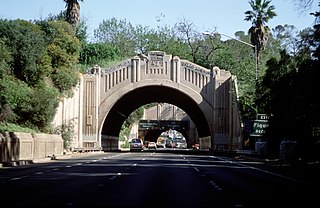
The Figueroa Street Tunnels are a set of four four-lane tunnels that carry northbound traffic on State Route 110 through Elysian Park in Los Angeles, California, United States. From south to north, the four tunnels measure 755, 461, 130, and 405 feet in length, 46.5 feet in width, and 28.3 ft in height.

Barrio Logan is a neighborhood in south central San Diego, California. It is bordered by the neighborhoods of East Village and Logan Heights to the north, Shelltown and Southcrest to the east, San Diego Bay to the southwest, and National City to the southeast. Interstate 5 forms the northeastern boundary. The Barrio Logan Community Plan Area comprises approximately 1,000 acres, of which slightly more than half is under the jurisdiction of the Port of San Diego or the United States Navy rather than the city of San Diego. The community is subject to the California Coastal Act. Though located near the city's central core, it has long been considered part of Southeast San Diego by many locals, being directly southeast of downtown San Diego, and with previous historical records labeling it as part of "Western Southeast San Diego."

Figueroa Street is a major north-south street in Los Angeles County, California, spanning from the Los Angeles neighborhood of Wilmington north to Eagle Rock. A short, unconnected continuation of Figueroa Street runs just south of Marengo Drive in Glendale to Chevy Chase Drive in La Cañada Flintridge.
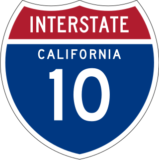
Interstate 10 (I-10) is a transcontinental Interstate Highway in the United States, stretching from Santa Monica, California, to Jacksonville, Florida. The segment of I-10 in California, also known as the Pearl Harbor Memorial Highway, runs east from Santa Monica through Los Angeles, San Bernardino, and Palm Springs before crossing into the state of Arizona. In the Greater Los Angeles area, it is known as the Santa Monica and San Bernardino freeways, linked by a short concurrency on I-5 at the East Los Angeles Interchange. I-10 also has parts designated as the Rosa Parks and Sonny Bono Memorial freeways. Some parts were also formerly designated as the Christopher Columbus Transcontinental Highway. However, the California State Legislature removed this designation following the passage of a bill on August 31, 2022. I-10 is also known colloquially as "the 10" to Southern California residents .

Cypress Park is a densely populated neighborhood of 10,000+ residents in Northeast Los Angeles, California. Surrounded by hills on three sides, it sits in the valley created by the Los Angeles River and the Arroyo Seco. It is the site of the Rio de Los Angeles State Park, the Los Angeles River Bike Path and other recreational facilities. It hosts one private and four public schools.

The Old Fourth Ward, often abbreviated O4W, is an intown neighborhood on the eastside of Atlanta, Georgia, United States. The neighborhood is best known as the location of the Martin Luther King Jr. historic site.

Cherry Hill is a neighborhood and predominantly residential area in Seattle, Washington located south of Capitol Hill within the Central District, north of the International District, and east of First Hill. Cherry Hill is bound on the west by 14th Avenue, on the east by 23rd Avenue, on the north by East Madison Street and on the south by East Yesler Way. Cherry Hill overlaps considerably with the neighborhood of Squire Park as defined by the Squire Park Neighborhood Council. In the Seattle City Clerk's Geographic Indexing Atlas, Cherry Hill is designated as the Minor neighborhood of the Central Area. Cherry Hill was previously called Second Hill or Renton Hill.
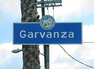
Garvanza is a neighborhood in northeast Los Angeles. Fourteen Los Angeles Historic-Cultural Monuments are located in the neighborhood.

Northeast Los Angeles is a 17.18 sq mi (44.5 km2) region of Los Angeles County, comprising seven neighborhoods within Los Angeles. The area is home to Occidental College located in Eagle Rock.
The San Antonio–San Diego Mail Line, also known as the Jackass Mail, was the earliest overland stagecoach and mail operation from the Eastern United States to California, in operation between 1857 and 1861. It was created, organized and financed by James E. Birch the head of the California Stage Company. Birch was awarded the first contract for overland service on the "Southern Route", designated Route 8076. This contract required a semi-monthly service in four-horse coaches, scheduled to leave San Antonio and San Diego on the ninth and the 24th of each month, with 30 days allowed for each trip.
References
- ↑ "maps barrio san antonio tucson". Google Maps. Retrieved 2012-08-12.
- ↑ [ dead link ]
- ↑ https://tucson-neighborhood-associations-cotgis.hub.arcgis.com/#Interactive-Map
- ↑ [ dead link ]
- ↑ "Mission Linen Supply & Uniform Services". Missionlinen.com. Retrieved 2012-08-12.
- ↑ "WEEKLY LIST OF ACTIONS TAKEN ON PROPERTIES: 4/5/2024 THROUGH 4/12/2024". National Park Service. Retrieved 2024-04-18.
- ↑ "RFCD Arroyo Chico Multi-Use Project Home Page". Rfcd.pima.gov. Retrieved 2012-08-12.
- ↑ "Tucson". The Drachman Institute. Archived from the original on 2012-03-06. Retrieved 2012-08-12.
- ↑ "Tucson Metro Bike Map" (PDF). Pagnet.org. Archived from the original (PDF) on 2011-07-27. Retrieved 2013-10-23.
- ↑ https://www.tucsonaz.gov/Departments/Fire/Request-Tucson-Fire-Services/Fire-Stations
- ↑ https://www.tucsonaz.gov/Departments/Police/TPD-Patrol-Divisions/Operations-Division-West