
The West End of London is a district of Central London, London, England, west of the City of London and north of the River Thames, in which many of the city's major tourist attractions, shops, businesses, government buildings and entertainment venues, including West End theatres, are concentrated.

Holborn, an area in central London, covers the south-eastern part of the London Borough of Camden and a part of the Ward of Farringdon Without in the City of London.

Covent Garden is a district in London, on the eastern fringes of the West End, between St Martin's Lane and Drury Lane. It is associated with the former fruit-and-vegetable market in the central square, now a popular shopping and tourist site, and with the Royal Opera House, itself known as "Covent Garden". The district is divided by the main thoroughfare of Long Acre, north of which is given over to independent shops centred on Neal's Yard and Seven Dials, while the south contains the central square with its street performers and most of the historical buildings, theatres and entertainment facilities, including the London Transport Museum and the Theatre Royal, Drury Lane.

Wardour Street is a street in Soho, City of Westminster, London. It is a one-way street that runs north from Leicester Square, through Chinatown, across Shaftesbury Avenue to Oxford Street. Throughout the 20th century the West End street became a centre for the British film industry and the popular music scene.
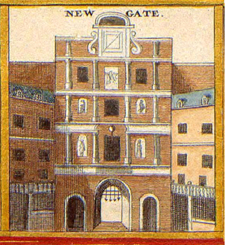
Newgate was one of the historic seven gates of the London Wall around the City of London and one of the six which date back to Roman times. Newgate lay on the west side of the wall and the road issuing from it headed over the River Fleet to Middlesex and western England. Beginning in the 12th century, parts of the gate buildings were used as a gaol, which later developed into Newgate Prison.
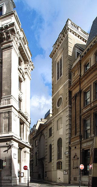
St Clement Eastcheap is a Church of England parish church in Candlewick Ward of the City of London. It is located on Clement's Lane, off King William Street and close to London Bridge and the River Thames.

Hatton Garden is a street and commercial zone in the Holborn district of the London Borough of Camden, abutting the narrow precinct of Saffron Hill which then abuts the City of London. It takes its name from Sir Christopher Hatton, a favourite of Queen Elizabeth I, who established a mansion here and gained possession of the garden and orchard of Ely Place, the London seat of the Bishops of Ely. It remained in the Hatton family and was built up as a stylish residential development in the reign of King Charles II. For some decades it often went, outside of the main street, by an alternative name St Alban's Holborn, after the local church built in 1861.
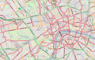
Central London is the innermost part of London, in England, spanning the City of London and several boroughs. Over time, a number of definitions have been used to define the scope of Central London for statistics, urban planning and local government. Its characteristics are understood to include a high-density built environment, high land values, an elevated daytime population and a concentration of regionally, nationally and internationally significant organisations and facilities.

Woodhouse is a largely residential area just north of the city centre of Leeds and close to the University of Leeds. The area considered as Woodhouse is partly in the Little London and Woodhouse ward and partly in the Headingley & Hyde Park ward of City of Leeds metropolitan district.
The WC postcode area, also known as the London WC postcode area, is a group of postcode districts in central London, England. The area covered is of high density development, and includes parts of the City of Westminster and the London Boroughs of Camden and Islington, plus a very small part of the City of London.

Gray's Inn Road is an important road in Central London, located in the London Borough of Camden. The road begins at its junction with Holborn at the City of London boundary, passes north through the Holborn and King's Cross districts and terminates at King's Cross railway station. It is designated as part of the A5200 road.
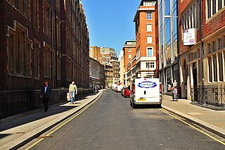
Chancery Lane is a one-way street that forms part of the western boundary of the City of London. The east side of the street is entirely within the City, whilst the west side is in the City of Westminster south of Carey Street and the London Borough of Camden north of that street. The route originated as a 'new lane' created by the Knights Templar from their original 'old Temple' on the site of the present Southampton Buildings on Holborn, in order to access to their newly acquired property to the south of Fleet Street sometime before 1161.
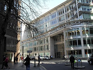
Fetter Lane is a street in the ward of Farringdon Without in the City of London, England. It forms part of the A4 road and runs between Fleet Street at its southern end and Holborn.
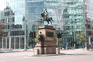
Holborn Circus is a five-way junction at the western extreme of the City of London, specifically between Holborn and its Hatton Garden part. Its main, east–west, route is the inchoate A40 road. It was designed by the engineer William Haywood and opened in 1867. The term circus describes how the frontages of the buildings facing curved round in a concave chamfer. These, in part replaced with glass and metal-clad buildings, remain well set back.

St James's Place is a street in the St James's district of London near Green Park. It was first developed around 1694, the historian John Strype describing it in 1720 as a "good Street ... which receiveth a fresh Air out of the Park; the Houses are well-built, and inhabited by Gentry ..." Henry Benjamin Wheatley wrote in 1870 that it was "one of the oddest built streets in London."
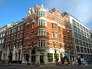
Berners Mansions is a six-storey Edwardian mansion block located in Berners Street in the City of Westminster. Berners Mansions was designed in 1897 by George Dennis Martin (1848-1915), Architect, of Pall Mall East. It is an unlisted building of merit within the Charlotte Street West Conservation Area and recognised as a positive contributor to the townscape of Berners Street and East Marylebone. It is a red brick building situated on the corner of Berners Street and Mortimer Street, opposite the site of the former Middlesex Hospital and comprises 10 residential flats and 4 ground floor shops.

Weymouth Street lies in the Marylebone district of the City of Westminster and connects Marylebone High Street with Great Portland Street. The area was developed in the late 18th century by Henrietta Cavendish Holles and her husband Edward Harley, 2nd Earl of Oxford. This part of Marylebone was noted to part of Manor of Tyburn and dates back to the year 1086.

Stocks Market was a market in central London operating between 1282 and 1737 and for centuries was London's main retail meat and produce market.
West London is the western part of London, England, north of the River Thames, west of the City of London, and extending to the Greater London boundary.

Whitechapel Mount was a large artificial mound of disputed origin. A prominent landmark in 18th century London, it stood in the Whitechapel Road beside the newly constructed London Hospital, being not only older, but significantly taller. It was crossed by tracks, served as a scenic viewing-point, could be ascended by horses and carts, and supported some trees and formal dwelling-houses. It has been interpreted as: a defensive fortification in the English Civil War; a burial place for victims of the Great Plague; rubble from the Great Fire of London; and as a laystall. Possibly all of these theories are true to some extent.


