Baruni Hill is a small hill in the Himalayan state of Manipur and the abode of God Nongpok Ningthou. [1]
Baruni Hill is a small hill in the Himalayan state of Manipur and the abode of God Nongpok Ningthou. [1]

Manipur is a state in Northeast India, with the city of Imphal as its capital. It is bounded by the Indian states of Nagaland to the north, Mizoram to the south and Assam to the west. It also borders two regions of Myanmar, Sagaing Region to the east and Chin State to the south. The state covers an area of 22,327 square kilometres (8,621 sq mi). Manipur has been at the crossroads of Asian economic and cultural exchange for more than 2,500 years. It connects the Indian subcontinent and Central Asia to Southeast Asia, East Asia, Siberia, regions in the Arctic, Micronesia and Polynesia enabling migration of people, cultures and religions.

Imphal is the capital city of the Indian state of Manipur. The metropolitan centre of the city contains the ruins of Kangla Palace, the royal seat of the former Kingdom of Manipur, surrounded by a moat. Spread over parts of the districts of Imphal West and Imphal East, the former contains the majority of the city's area and population. Imphal is part of the Smart Cities Mission under the Ministry of Housing and Urban Affairs.
Manipur University is a central university located in Imphal, Manipur, India. It was established on 5 June 1980, under the Manipur University Act, 1980, as a teaching cum-affiliating university with territorial jurisdiction over the state of Manipur. It was converted into a central university under the Manipur University Act, 2005 w.e.f. 13 October 2005.
The Hmar language or Khawsak ṭawng belongs to the Kukish branch of the Sino-Tibetan family of languages. The speakers of the language are also known as Hmar. According to the official 2011 Census of India, there are 29,268 Hmar/Khawsak speakers in Assam, 48,375 in Manipur, 1,700 in Meghalaya, 18,587 in Mizoram although Majority of the Hmars in Mizoram speak Duhlian (Mizo).
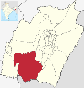
Churachandpur District, is one of the 16 districts in the southwestern corner of the Indian state of Manipur that covers an area of 4,750 kilometres (2,950 mi). It is named after the Meitei King Churachand Singh, the Maharaja of Manipur Kingdom. Churachandpur district which was previously known as Manipur South District came into existence in the year 1969 along with the district reorganization of Manipur. It stretches between 93° 15’E and 94° 45΄E Longitude and between 24°N and 24° 30 N Latitudes.
Keikhu are two twin villages in Manipur, India. They are located at approximately 25 N 94 E. 2 km ESE of Imphal, capital of the state of Manipur. The village in the south is inhabited by the Kabui tribes. The early settlers of the place. The one in the north belongs to a mixed tribe who identifies themselves as "Pangal", a collective term used for Manipuri-Muslims.

Ukhrul district is an administrative district of the state of Manipur in India with its headquarters at Ukhrul, that is Hunphun. The district occupies the north-eastern corner of the state and it extends between latitudes of 24° 29′ and 25° 42′ N and longitudes 94° 30′ and 94° 45′ E approximately. It shares an international boundary with Myanmar (Burma) on its eastern side and is bounded by Nagaland state in the north, Senapati district and Kangpokpi district in the west and Kamjong district in the south. It has the distinction of being the highest hill station of Manipur. The terrain of the district is hilly with a varying heights of 913 m to 3114 m (MSL). Ukhrul, the district HQ., at an altitude of 2020 m (MSL) is linked with Imphal, the state capital by NH 202 which is about 84 kilometres apart. The district covers an area of 4,544 square kilometres including Kamjong district making it the second largest district of the state after Churachandpur district and has a population of almost 1,83,998 according to Census of India 2011 comprising about 6.44 per cent of the total state population. The Tangkhul Naga tribe constitute the major bulk of the population with other communities such as Thadou, Nepalese and other non-tribals constituting a small percentage of the district population. Administratively, the district which comprises around 200 villages was divided into five sub-divisions, where their boundaries were coterminous with that of the Tribal Development Blocks. There was no statutory town in the district except one census town which was formed in 2011 Census. Recently, Kamjong district was carved out from Ukhrul District as a separate district. Ukhrul District has three assembly constituencies before the bifurcation of the district which are Phungyar Assembly Constituency (43-ST), Ukhrul Assembly Constituency (44-ST) and Chingai Assembly Constituency. The district is best introduced by its rare Shirui Lily,. Also, the district has provided two of Manipur's chief ministers and the only from amongst the hill districts of Manipur, Yangmaso Shaiza the first tribal chief minister of Manipur and Rishang Keishing who is also the first MP from Outer Manipur. William Pettigrew (missionary), an educationist and a Scottish-British Christian Missionary pioneered the western system of education and introduced the Christianity faith among the Tangkhal Naga tribe. Phungyo Baptist Church, Tangrei, Ukhrul, the oldest and the first Christian church of Manipur which still stands today is a testament to his passion for missionary work.

The Zou people are an indigenous community living along the frontier of India and Burma, they are a sub-group of the Zo people (Mizo-Kuki-Chin). In India, they live with and are similar in language and habits to the Paite and the Simte peoples. In Burma, the Zou are counted among the Chin people.They are a hill people, "Zou" may plainly means "Hills" denoting the Zous are "people of the hills" or "of the hills", and "Zou" has also a different meaning in Zou language that is "complete" or another word for it is "finish". But, the Zou people believed that they incepted the name 'Zou' from their forefather 'Zou' or 'Zo', believed to be the progenitor of the broad Chin-Kuki-Mizo people. The Zous can be found in different parts of India and also of the world.
Central Agricultural University is an agricultural university at Lamphelpat, Imphal in the Indian state of Manipur.

Sulayman al-Baruni was a Berber Ibadi scholar, poet, statesman and a prominent figure in the history of Libya.
The Manipur Pradesh Congress Committee is the unit of the Indian National Congress for the state of Manipur, India. Its head office is situated at the Congress Bhawan, B.T. Road, Imphal.

The People's Liberation Army of Manipur, often shortened to just People's Liberation Army, founded by N. Bisheshwar Singh on 25 September 1978, is a separatist armed terrorist group fighting for a separate independent socialist state of Manipur, a state in northeastern India. Though it claims to fight for the entire state, the Nagas, Kukis and the tribals in the state are not part of the group. The cadres are drawn from the Meitei people and the Pangal people.

Thakurnagar is a town in the Indian state of West Bengal. It is close to the border with Bangladesh. It is situated on the east side of the Jessore Road. Thakurnagar is famous for "Baruni Mela".

The Manipur Kingdom was an ancient independent kingdom at the India–Burma frontier that was in subsidiary alliance with British India from 1824, and became a princely state in 1891. It bordered Assam Province in the west and British Burma in the east, and in the 20th century covered an area of 22,327 square kilometres and contained 467 villages. The capital of the state was Imphal.
Ningthoukhongjam Khelchandra Singh was an Indian writer, lexicographer and historian, known as the author of Manipuri to Manipuri and English, the first modern general dictionary in Meitei language, which was published in 1964. He was a fellow of the Sahitya Akademi and Sangeet Natak Akademi. The Government of India awarded him the fourth highest civilian honour of Padma Shri in 1987.

The Cinema of Manipur is the film industry based in Manipur, India. It includes not only Meitei language movies but all the films made in different languages of the different communities in Manipur. The Manipuri film industry was born when Matamgi Manipur was released on 9 April 1972. Before this, there were many attempts to make a film in the state, the most significant being Mainu Pemcha in 1948 which was left incomplete due to various problems.

Lugongbagi Ahing is a 2011 Manipuri film directed by Bijgupta Laishram and produced by T. Baruni Devi, under the banner of Baruni Films. The film features Gokul Athokpam, Bala Hijam and Ashok Seleibam in the lead roles. The film was released at Classic Hotel, Imphal on 3 June 2011. It is a 2011 blockbuster film.

Thangjing Hill is a mountain range in the Indian state of Manipur, India. The hill range is the abode of God Eputhou Thangjing and other Meitei deities in Meitei mythology. The temple of Lord Eputhou Thangjing at the Hill top is a major pilgrimage site for followers of Sanamahi faith in Manipur.

Nongpok Ningthou, also known as Sovereign of the East or King of the East, is a deity in Meitei mythology and religion of Ancient Kangleipak. He is the ruling guardian deity of the eastern direction. Legend says Nongpok Ningthou and Panthoibi got united in the Nongmaiching hills. Later, they were worshipped as the civilization giving deities in Meitei religion.