Geelong is a port city in the southeastern Australian state of Victoria, located at the eastern end of Corio Bay and the left bank of Barwon River, about 65 km (40 mi) southwest of Melbourne, the state capital of Victoria.

The City of Greater Geelong is a local government area in the Barwon South West region of Victoria, Australia, located in the western part of the state. It covers an area of 1,248 square kilometres (482 sq mi) and, had a population of 271,057 as of the 2021 Australian census. It is primarily urban with the vast majority of its population living in the Greater Geelong urban area, while other significant settlements within the LGA include Anakie, Balliang, Barwon Heads, Batesford, Ceres, Clifton Springs, Drysdale, Lara, Ocean Grove, Portarlington and St Leonards. It was formed in 1993 from the amalgamation of the Rural City of Bellarine, Shire of Corio, City of Geelong, City of Geelong West, City of Newtown, City of South Barwon, and parts of Shire of Barrabool and Shire of Bannockburn.

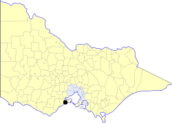
The Surf Coast Shire is a local government area in the Barwon South West region of Victoria, Australia, located in the south-western part of the state. It covers an area of 1,553 square kilometres (600 sq mi) and in June 2018 had a population of 32,251. It includes the towns of Aireys Inlet, Anglesea, Lorne, Moriac, Torquay and Winchelsea. It was formed in 1994 from the amalgamation of the Shire of Winchelsea, Shire of Barrabool and part of the former City of South Barwon, which was, at that point, part of the City of Greater Geelong.

Werribee is a suburb in Melbourne, Victoria, Australia, 32 km (20 mi) south-west of Melbourne's Central Business District, located within the City of Wyndham local government area. Werribee recorded a population of 50,027 at the 2021 census.

Grovedale is a southern suburb of Geelong, Victoria, Australia. At the 2021 census, Grovedale had a population of 14,869.
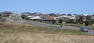
Waurn Ponds is a mainly residential southern suburb of Geelong, Victoria, Australia.
Highton is a residential suburb of Geelong, Victoria, Australia. With views across Geelong, Corio Bay and the surrounding region, Highton is located along the banks of the Barwon River and across the rolling Barrabool Hills. The Barwon River straddles Highton to the north and east, while it is bordered by the hilly Ceres and Wandana Heights to the west, the former Kardinia Creek separates the suburb from Belmont to the south-east, and the Princes Highway and Pigdons Road to the south separate the suburb from Waurn Ponds.

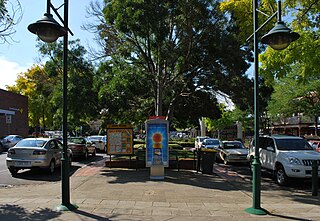
South Geelong, also referred to as Geelong South, is a southern suburb of Geelong, Victoria, Australia. Its local government area is the City of Greater Geelong. At the 2016 census, South Geelong had a population of 993.

The Geelong Ring Road is a freeway ring road in Australia beside Geelong's western suburbs from the Princes Freeway at Corio to the Princes Highway at Waurn Ponds. It also connects to the Midland Highway towards Ballarat, and the Hamilton Highway.

St John of God Geelong Hospital is a 284-bed hospital providing inpatient and outpatient care in the Barwon and south-west regions of Victoria.

The Moorabool River is a river in Victoria, Australia that runs past several small towns and areas such as Meredith, Anakie, and Staughton Vale. The river joins with the Barwon River at Fyansford.
St John of God Health Care is a Catholic provider of health care services in Australia, with 24 hospitals and facilities comprising more than 3,400 beds. The group operates in Western Australia, New South Wales, Victoria, and New Zealand.

Deakin University's School of Medicine is based at the Waurn Ponds campus in Geelong, Victoria, Australia. It offers a four-year, graduate-entry, Doctor of Medicine (MD) degree.

The University Hospital Geelong, formerly the Geelong Hospital, is an Australian public hospital located in Ryrie Street, Geelong, Victoria. The hospital is part of Barwon Health, Victoria's largest regional health care provider, which has 21 sites. It is the largest hospital in regional Victoria and the only tertiary hospital outside of the Melbourne Metropolitan area. The site is bounded by Ryrie, Bellarine, Myers, and Swanston Streets.
Healthscope is a for-profit Australian company which operates private hospitals, medical centres and rehabilitation hospitals. The company is headquartered on St Kilda Road, Melbourne. It operates medical/surgical hospitals and a number of psychiatric and rehabilitation hospital clinics.
The City of South Barwon was a local government area in Victoria, Australia, which contained a number of Geelong suburbs south of the Barwon River, and extending to Torquay in the south and Barwon Heads to the east. The city covered an area of 165.4 square kilometres (63.9 sq mi), and existed from 1863 until 1994.
St John of God Ballarat Hospital provides hospital care for people living in Ballarat and Western Victoria regions of Australia.

The Barwon South West is an economic rural region located in the southwestern part of Victoria, Australia. The Barwon South West region stretches from the tip of the Queenscliff Heads to the border of South Australia. It is home to Victoria’s largest provincial centre, Geelong and the major centres of Aireys Inlet, Apollo Bay, Camperdown, Colac, Hamilton, Lorne, Port Campbell, Port Fairy, Portland, Torquay and Warrnambool. It draws its name from the Barwon River and the geographic location of the region in the state of Victoria.
The Victorian regional leagues are the eighth level of soccer in Victoria, Australia, and the ninth nationally. The league consists of eight separate regional senior leagues and is administered by the Football Federation Victoria.

AFL Barwon Women's Football is a women's Australian rules football competition based in the greater Geelong region. The first season of senior football held for women in the area was 2018.