Related Research Articles
Westerlo is a town in Albany County, New York, United States. The population was 3,194 at the 2020 census.

Nanticoke is a town in Broome County, New York, United States. The population was 1,672 at the 2010 census. The town was named after the Nanticoke people, who were a Native American tribe native to Chesapeake Bay.

Richfield is a town located in Otsego County, New York, United States. As of the 2020 census, the town had a population of 2,065. The Town of Richfield is located at the northern border of the county.
Westford is a town in Otsego County, New York, United States. The population was 868 at the 2010 census. It is southeast of Cooperstown.

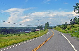
Esperance is a town in Schoharie County, New York, United States. The population was 1,806 at the 2020 census. The town was given the name of the principal village, which was named for "hope" in French.

Wawayanda Creek is the name of Pochuck Creek above its confluence with the tributary Black Creek. It is 17.0 miles (27.4 km) long. Wawayanda Creek, via Pochuck Creek, is a tributary of the Wallkill River in Sussex County, New Jersey in the United States. It starts northeast of Warwick, New York, and runs southwest, mostly within Orange County, flowing into New Jersey for several miles to its confluence with Black Creek just north of Highland Lakes, forming Pochuck Creek, which flows north back into New York.
There are several lakes named Mud Lake within the U.S. state of North Dakota.
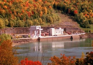
The Blenheim–Gilboa Pumped Storage Power Station is a pumped-storage hydroelectricity plant in the Catskill Mountains of New York State. The plant is part of the New York Power Authority, and can generate over 1,100 megawatts (1,500,000 hp) of electricity. It is used daily to cover peak demand. There are two reservoirs that are involved in the project, both with a capacity of 5 billion US gallons (19,000,000 m3); one at the foot of Brown Mountain in the Schoharie Valley, and another one at the top of the mountain. The power station has an accumulated capacity of about 12,000 megawatt-hours (43,000 GJ) after storing up to 17,000 megawatt-hours (61,000 GJ).
Fort Hunter is a hamlet in the Town of Florida in Montgomery County, New York, United States, west of the capital at Albany, on the south bank of the Mohawk River and on the northeast bank of Schoharie Creek.
Brandywine Creek is a 3.0-mile-long (4.8 km) tributary of Quittapahilla Creek in Lebanon County, Pennsylvania, in the United States.
Oliverea is a populated place in Ulster County, New York, United States. It is situated on Esopus Creek along Ulster Country Route 47 within Catskill State Park. The community is located at 42°03′55″N74°27′37″W in the Town of Shandaken.
Black Meadow Creek is a 9.7-mile-long (15.6 km) tributary of the Otter Kill in Orange County, New York, in the United States. Via the Otter Kill, it is part of the Moodna Creek watershed, flowing onward to the Hudson River, in one of New York State's most biodiverse natural areas. Home to 13 species of salamander as well as to New York's largest population of the Northern Cricket Frog, the state's only listed "Endangered" frog species, the creek area is considered by biologists to be one of the state's herpetological "hot spots". Black Meadow Creek has several confirmed bald eagle nests along its length.

Kaaterskill Clove is a deep gorge, or valley, in New York's eastern Catskill Mountains, lying just west of the village of Palenville and in Haines Falls. The clove was formed by Kaaterskill Creek, a tributary of Catskill Creek rising west of North Mountain, and is estimated by geologists to be as much as 1 million years old. Kaaterskill High Peak and Roundtop Mountain rise to the south of the gorge, while South Mountain is to its north. This makes the gorge as deep as 2,500 feet in places.
Oak Hill is a hamlet within the town of Durham in Greene County, New York, United States. Its elevation is 643 feet (196 m) above sea level. It has the ZIP Code 12460 and the Telephone Area Code 518.
Franklinton Vlaie or "The Vlaie" is a tributary of Catskill Creek in Broome, Schoharie County, New York in the United States.

Aetna Township is a civil township of Missaukee County in the U.S. state of Michigan. As of the 2020 census, the township population was 429.
Saratoga Springs Air Force Station is a closed United States Air Force General Surveillance Radar station. It is located 7.2 miles (11.6 km) southeast of Saratoga Springs, New York. It was closed by the Air Force in 1977.
Sturgeon Creek is a stream in the U.S. state of Washington.
References
- ↑ U.S. Geological Survey Geographic Names Information System: Basic Creek
- ↑ University of the State of New York Bulletin. University of the State of New York. 1914. p. 45.
42°21′13″N74°03′15″W / 42.35361°N 74.05417°W