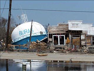
Buras-Triumph is a former census-designated place in Plaquemines Parish, Louisiana, United States. The population was 3,358 at the 2000 census. For the 2010 census, Buras-Triumph was split into the CDPs of Buras and Triumph. On the peninsula, Buras has been located higher, with Triumph located southeast of Buras.

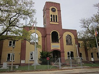
Chalmette is a census-designated place (CDP) in, and the parish seat of, St. Bernard Parish in southeastern Louisiana, United States. The 2010 census reported that Chalmette had 16,751 people; 2011 population was listed as 17,119; however, the pre-Katrina population was 32,069 at the 2000 census. At the 2020 U.S. census, its population rebounded to 21,562. Chalmette is part of the New Orleans–Metairie–Kenner metropolitan statistical area. Chalmette is located east of downtown New Orleans and south of Arabi, towards Lake Borgne.
An environmental disaster or ecological disaster is defined as a catastrophic event regarding the natural environment that is due to human activity. This point distinguishes environmental disasters from other disturbances such as natural disasters and intentional acts of war such as nuclear bombings.
Pointe à la Hache is a census-designated place (CDP) and unincorporated community in Plaquemines Parish, Louisiana, United States. Located on the east bank of the Mississippi River, the village has been the seat for Plaquemines Parish since the formation of the parish. As of the 2020 census, its population was 183, less than half its 1930 population. It suffered severe damage from Hurricane Katrina in 2005 and Tropical Storm Lee in 2011.
The Chemical Coast is a section of Union and Middlesex counties in New Jersey located along the shores of the Arthur Kill, across from Staten Island, New York. The name is taken from the Conrail Chemical Coast Line, an important component in the ExpressRail system serving marine terminals in the Port of New York and New Jersey.
Oil Storm is a 2005 television simulation portraying a future oil-shortage crisis in the United States, precipitated by a hurricane destroying key parts of the United States' oil infrastructure. The program was an attempt to depict what would happen if the highly oil-dependent country was suddenly faced with gasoline costing upwards of $7 to $8 per gallon. Directed by James Erskine and written by Erskine and Caroline Levy, it originally aired on FX Networks on 5 June 2005, at 8 p.m. ET.

Hurricane Katrina was a devastating tropical cyclone that caused 1,392 fatalities and damages estimated at $125 billion in late August 2005, particularly in the city of New Orleans and its surrounding area. Katrina was the twelfth tropical cyclone, the fifth hurricane, and the third major hurricane of the 2005 Atlantic hurricane season. It was also the fourth-most intense Atlantic hurricane to make landfall in the contiguous United States, gauged by barometric pressure.
The economic effects of Hurricane Katrina, which hit Louisiana, Florida, Texas and Mississippi in late August 2005, were far-reaching.

Hurricane Rita was the most intense tropical cyclone on record in the Gulf of Mexico and the fourth-most intense Atlantic hurricane ever recorded. Part of the record-breaking 2005 Atlantic hurricane season, which included three of the top ten most intense Atlantic hurricanes in terms of barometric pressure ever recorded, Rita was the seventeenth named storm, tenth hurricane, and fifth major hurricane of the 2005 season. It was also the earliest-forming 17th named storm in the Atlantic until Tropical Storm Rene in 2020. Rita formed near The Bahamas from a tropical wave on September 18, 2005 that originally developed off the coast of West Africa. It moved westward, and after passing through the Florida Straits, Rita entered an environment of abnormally warm waters. Moving west-northwest, it rapidly intensified to reach peak winds of 180 mph (285 km/h), achieving Category 5 status on September 21. However, it weakened to a Category 3 hurricane before making landfall in Johnson's Bayou, Louisiana, between Sabine Pass, Texas and Holly Beach, Louisiana, with winds of 115 mph (185 km/h). Rapidly weakening over land, Rita degenerated into a large low-pressure area over the lower Mississippi Valley by September 26.

Audubon Aquarium is an aquarium in New Orleans, Louisiana, United States. After a $41 million dollar renovation that would see the Audubon Insectarium merge with the facility, the aquarium reopened with new exhibits and experiences on June 8, 2023. The Audubon Nature Institute runs the aquarium, and the institute also supervises the Audubon Zoo, Audubon Louisiana Nature Center, Freeport-McMoRan Audubon Species Survival Center, Audubon Center for Research of Endangered Species (ACRES), Coastal Wildlife Network, Audubon Wilderness Park, and Audubon Park. The aquarium is located along the banks of the Mississippi River by the edge of the historic French Quarter off Canal Street, at the upper end of Woldenberg Park and originally opened on September 1, 1990.

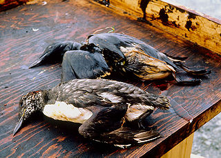
The Murphy Oil USA refinery spill was an oil spill that resulted from the failure of a storage tank at the Murphy Oil USA petroleum refinery in the residential areas of Chalmette and Meraux, Louisiana, United States, on August 30, 2005, the day after Hurricane Katrina made landfall on the U.S. Gulf Coast.
O'Brien's Response Management is the largest oil spill management company in the United States

Breton National Wildlife Refuge is located in southeastern Louisiana in the offshore Breton Islands and Chandeleur Islands. It is located in the Gulf of Mexico and is accessible only by boat. The refuge was established in 1904 through executive order of President Theodore Roosevelt and is the second-oldest refuge in the National Wildlife Refuge System.
Greka Energy, legally HVI Cat Canyon Inc., is a privately held company engaged in hydrocarbon exploration principally in Santa Barbara County, California. Formed in 1999 after the acquisition and merger of several smaller firms, it is a subsidiary of Greka Integrated, Inc., a holding company headquartered in Santa Maria, California, and is wholly owned by Randeep Grewal.

The Morris J. Berman oil spill occurred on January 7, 1994, when the Morris J. Berman, a single-hull 302-foot-long barge, with the capacity to carry more than 3 million gallons of oil, collided with a coral reef near San Juan, Puerto Rico, causing the release of 750,000 gallons of heavy grade oil. The spill affected the tourism and fishing industries as well as wildlife along the shores of Puerto Rico, Isla de Culebra, and Isla de Vieques. The spill had major long-lasting impacts on the biological and natural resources of the entire Puerto Rican area. This spill was also the first to occur in U.S. waters after the passing of the Oil Pollution Act of 1990.

The Bouchard Oil Spill was a 2003 oil spill in Westport, Massachusetts. On Sunday April 27, 2003, the Tank Barge Bouchard No. 120 struck rocks south of Westport, Massachusetts. This resulted in a puncture of the barge's hull about twelve feet in length. As a result, the cargo of the barge, number 6 fuel oil, spilled into the waters of Buzzards Bay, Massachusetts. While the spill was much smaller than many oil spills, the environmental impacts were felt for years. Estimates of the total amount spilled range from 22,000 to 98,000 gallons of oil according to a publication by the National Oceanic and Atmospheric Administration.
Following is a timeline of the Deepwater Horizon oil spill for July 2010.
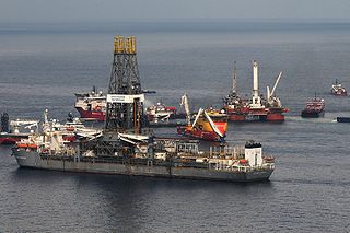
The Deepwater Horizon oil spill occurred between 10 April and 19 September 2010 in the Gulf of Mexico. A variety of techniques were used to address fundamental strategies for addressing the spilled oil, which were: to contain oil on the surface, dispersal, and removal. While most of the oil drilled off Louisiana is a lighter crude, the leaking oil was of a heavier blend which contained asphalt-like substances. According to Ed Overton, who heads a federal chemical hazard assessment team for oil spills, this type of oil emulsifies well. Once it becomes emulsified, it no longer evaporates as quickly as regular oil, does not rinse off as easily, cannot be broken down by microbes as easily, and does not burn as well. "That type of mixture essentially removes all the best oil clean-up weapons", Overton said.

Whetstone Brook is a tributary of the Connecticut River that runs through the heart of Brattleboro, Vermont, in the United States. It flows into the Connecticut at an elevation of 250 feet (76 m) above sea level. The headwater for the brook is at Hidden Lake, which is 1,500 feet (460 m) above sea level in the town of Marlboro. Of the 28-square-mile (73 km2) watershed, over two thirds is contained within Brattleboro, while another 30 percent is in Marlboro. The remaining 2% is within the town of Dummerston. The brook is crossed by Creamery Covered Bridge in West Brattleboro, which was built in 1879. The original Abenaki name for the waterway is Kitadowôganisibosis.
The 2004 Taylor Energy oil spill is an ongoing spill located in the Gulf of Mexico, around 11 miles (18 km) off the coast of the U.S. state of Louisiana. It is the result of the destruction of a Taylor Energy oil platform during Hurricane Ivan in 2004. It is the longest-running oil spill in U.S. history. It was first brought to public attention when contamination at the site was noticed in 2010 by those monitoring the nearby Deepwater Horizon oil spill. A report by the Associated Press in 2015 challenged the estimates of the extent of the leak originally given by the company and the U.S. Coast Guard (USCG), which were then revised to be around 1,000 times greater than initially reported.