Bassin de Naurouze

Last updated

Coordinates: 43°21′09″N1°49′15″E / 43.3525°N 1.820833°E / 43.3525; 1.820833 
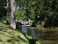
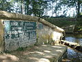
The Bassin de Naurouze is an octagonal holding tank, created during the building of the Canal du Midi as designed and built by Pierre-Paul Riquet. It was abandoned a few years after construction of the canal because of its recurrent silting problems. The flow of water from the Bassin de Saint-Ferréol joins the Canal du Midi at this point near the Seuil de Naurouze. Riquet hoped to build a city around the basin and also considered building a port. However, it easily filled with silt and its use discontinued. A lawn replaced the empty pool, and it is crossed by a straight path lined with plane trees. [1] [2]

Geographic coordinate system Coordinate system

A geographic coordinate system is a coordinate system that enables every location on Earth to be specified by a set of numbers, letters or symbols. The coordinates are often chosen such that one of the numbers represents a vertical position and two or three of the numbers represent a horizontal position; alternatively, a geographic position may be expressed in a combined three-dimensional Cartesian vector. A common choice of coordinates is latitude, longitude and elevation. To specify a location on a plane requires a map projection.

Canal du Midi canal in Southern France

The Canal du Midi is a 240 km (150 mi) long canal in Southern France. Originally named the Canal royal en Languedoc and renamed by French revolutionaries to Canal du Midi in 1789, the canal was at the time considered one of the greatest construction works of the 17th century.

Pierre-Paul Riquet French engineer

Pierre-Paul Riquet, Baron de Bonrepos was the engineer and canal-builder responsible for the construction of the Canal du Midi.

Bassin de Naurouze CdM - Bassin de Naurouze.jpg
Bassin de Naurouze

Related Research Articles

François Andréossy French engineer

François Andréossy (1633–1688) was a French engineer, cartographer, and a citizen of Narbonne. He was born in Paris on 10 June 1633. After completing his engineering studies in Paris, Andréossy went to Italy in 1660 to study Italian canal technology in Lombardy and Padua. He returned from the trip and sought out Pierre-Paul Riquet as a patron. Riquet was beginning his investigation into the possibility of building a canal across southern France from the Atlantic to the Mediterranean. Andréossy supplied the technical expertise that Riquet lacked and became Riquet's right-hand man throughout the construction of the canal.

Fonserannes Locks lock

Fonserannes Locks are a flight of staircase locks on the Canal du Midi near Béziers.

Canal Latéral de la Garonne canal

The Canal de Garonne, formerly known as Canal latéral à la Garonne, is a French canal dating from the mid-19th century which connects Toulouse to Castets-en-Dorthe. The remainder of the route to Bordeaux uses the river Garonne. It is the continuation of the Canal du Midi which connects the Mediterranean with Toulouse.

Canal de lOurcq Canal in northeastern France

The Canal de l'Ourcq is a 108.1 km (67.2 mi) long canal of in the Île-de-France region with 10 locks. It was built at a width of 3.20 m (10.5 ft) but was enlarged to 3.7 m (12 ft), which permitted use by more pleasure boats. The canal begins at Port-aux-Perches near the village of Troesnes, where it splits from the channeled River Ourcq, and flows to the Bassin de la Villette, where it joins the Canal Saint-Martin. Paris requires 380 000 m3 of water daily for cleaning the sewer system, gutters, and parks. The Canal de l'Ourcq provides about half of the requirement. Since 1983, the waterway has been designated for use by pleasure craft, and its water is designated for non-drinking uses.

Locks on the Canal du Midi Wikimedia list article

There are 91 working locks on the Canal du Midi along its 240-kilometre (150 mi) course from the Bassin du Thau on the Mediterranean coast to the junction with the Canal lateral a la Garonne in Toulouse. There are a further 13 locks on the 37-kilometre (23 mi) La Nouvelle branch which runs through Narbonne to the Mediterranean at Port-la-Nouvelle. The locks are all under the management of the French navigation authority, Voies navigables de France.

Orb Aqueduct

The Orb Aqueduct is a bridge which carries the Canal du Midi over the Orb in the city of Béziers in Languedoc, France. The aqueduct is 28 metres (92 ft) wide, 12 metres (39 ft) tall and at 240 metres (790 ft) is the longest on the Canal du Midi.

Ouvrages du Libron dam in France

Ouvrages du Libron is a structure like no other on the Canal du Midi. It allows the Libron River, near Agde in south-west France, to traverse the Canal du Midi. At the point of intersection, the Libron is more or less at the same level as the Canal du Midi so a traditional aqueduct was not an option. The problem was further exacerbated by the Libron's propensity to flash flood up to twenty times a year. The problem was originally solved by the building of a pontoon aqueduct known as the Libron Raft which utilised a flush-decked barge to protect the canal channel in times of flooding. However, this was replaced by the present structure in 1855.

Bassin de Saint-Ferréol lake

The Bassin de Saint-Ferréol was created as the result of a large earth dam across the mouth of the valley of Laudot stream at St. Ferréol in the Montagne Noire. It was originally proposed by Chevalier de Clerville and accepted by Pierre Paul Riquet as an integral part of the Canal du Midi. Riquet needed to provide a sufficient water reservoir to allow the locks to function year round, even in the dry summer season. The dam was begun on 15 April 1667 and was completed in four years. It was the first dam built specifically to supply water to a navigable canal and was by far the greatest single work of civil engineering undertaken during the building of the Canal du Midi.

Seuil de Naurouze

The Seuil de Naurouze, or Col de Naurouze, is the highest point of the Canal du Midi in southern France. It is the watershed point identified by Pierre-Paul Riquet when he designed and built the canal. Water falling on the western side of this point flows to the Atlantic Ocean and on the eastern side to the Mediterranean Sea. It is on the border of the department of Haute-Garonne and the department of the Aude.

Pierre Campmas, fontainer of Revel, assisted Pierre-Paul Riquet in his earliest design of the Canal du Midi. He helped Riquet confirm that the valleys of the Montagne Noire could provide sufficient water for the canal and helped Riquet build model canal workings at Riquet's estate, Bonrepos.

Cesse Aqueduct

Cesse Aqueduct is one of several aqueducts, or water bridge, created for the Canal du Midi. Originally, the canal crossed the Cesse on the level. Pierre-Paul Riquet, the original architect of the canal, had placed a curved dam 205 metres (673 ft) long and 9.10 metres (29.9 ft) high across the Cesse in order to collect water to make the crossing possible; the aqueduct replaced this dam.

Répudre Aqueduct navigable aqueduct

The Répudre Aqueduct is the first aqueduct built on the Canal du Midi. Pierre-Paul Riquet designed it to cross the Répudre River. It was built by Emmanuel d'Estan. It was designed in 1675 and completed in 1676, but was severely damaged that winter and had to be rebuilt. It is one of three original aqueducts created by Pierre-Paul Riquet during the building of the canal from 1667 to 1681.

Louis Nicolas de Clerville, a.k.a. Chevalier de Clerville, held many military positions during his life in France in 1610–1677. He was associated with Pierre-Paul Riquet and the building of the Canal du Midi.

The rigole de la montagne was an important facet of the Canal du Midi, engineered by Pierre-Paul Riquet in southern France. The canal itself was built during 1666-1681. A critical aspect of the Canal du Midi was the supply of sufficient water to feed the canal. Each boat traversing its length would require a large quantity of water in the locks in order to climb or descend.

The Bassin de Lampy was created during 1777 and 1781 when a dam was placed on the Lampy Valley in the Aude department in south-central France. The reservoir provides a source of water for the Canal du Midi. It was originally proposed in 1665 by the commission created by Louis XIV of France to evaluate Pierre-Paul Riquet's plan for the canal enterprise.

The balancing of incoming and outgoing water allows the Canal du Midi to operate as it does. Each time a lock operates, large quantities of water are either required to fill it or dump from it into the lower level pound. There must be a constant source of water in order to fill and the excess water dumped must have a place to exit the canal without it overflowing. Being able to provide this water source was one of the most important problems to be solved by Pierre Paul Riquet, its creator.

References

  1. Rolt, L. T. C. (1973). From Sea to Sea: The Canal Du Midi. Ohio University Press. ISBN   978-0-8214-0152-1.
  2. Mukerji, Chandra (2009). Impossible Engineering: Technology and Territoriality on the Canal du Midi. Princeton University Press. ISBN   978-0-691-14032-2.
Riquet Obelisk

The Riquet Obelisk is dedicated to the creator of the Canal du Midi, Pierre-Paul Riquet. In 1827, the heirs of Riquet built the monument. The obelisk has a dedication: "To Pierre-Paul Riquet, Baron Bonrepos, author of the Two Seas Canal in Languedoc". It is erected near the site of the former octagonal holding tank, called the Bassin de Naurouze, created during the building of the Canal du Midi.

Rigole de la plaine river in France

The critical feature of the Canal du Midi was to provide sufficient water to ensure that the lock system continued to function, even through the summer months. The first part of this endeavor was the rigole de la plaine. It carried water from the Sor River, at Pontcrouzet, to the Bassin de Naurouze, where the water was to enter the canal. This was done in 1667.