
Cartagena, known since the colonial era as Cartagena de Indias, is a city and one of the major ports on the northern coast of Colombia in the Caribbean Coast Region, along the Caribbean sea. Cartagena's past role as a link in the route to the West Indies provides it with important historical value for world exploration and preservation of heritage from the great commercial maritime routes. As a former Spanish colony, it was a key port for the export of Bolivian silver to Spain and for the import of enslaved Africans under the asiento system. It was defensible against pirate attacks in the Caribbean. The city's strategic location between the Magdalena and Sinú Rivers also gave it easy access to the interior of New Granada and made it a main port for trade between Spain and its overseas empire, establishing its importance by the early 1540s.

A city gate is a gate which is, or was, set within a city wall. It is a type of fortified gateway.
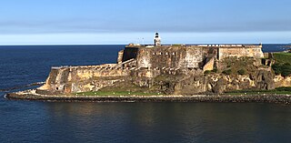
Castillo San Felipe del Morro, commonly known as El Morro(The Promontory), is a large fortress and citadel in the historic district of Old San Juan, Puerto Rico. Commissioned by Charles I of Spain in 1539, it was first built as a fortified tower in honor of Philip II, who oversaw its expansion into a hornwork fort by 1595. Over the next 200 years, especially in the reign of Charles III, El Morro continued to be developed to reach its current form in 1787. Rising 140 ft from the Atlantic shoreline with 18 to 25 ft thick walls, it stands on a steep, rocky headland promontory on San Juan Islet guarding the entry to San Juan Bay, the harbor of Old San Juan. El Morro, alongside La Fortaleza, San Cristóbal, El Cañuelo, and other forts part of the Walls of Old San Juan, protected strategically and militarily important Old San Juan, La Llave de las Indias , from invasion by competing world powers during the Age of Sail.

Old San Juan is a historic district located at the "northwest triangle" of the islet of San Juan in San Juan. Its area roughly correlates to the Ballajá, Catedral, Marina, Mercado, San Cristóbal, and San Francisco sub-barrios (sub-districts) of barrio San Juan Antiguo in the municipality of San Juan, Puerto Rico. Old San Juan is the oldest settlement within Puerto Rico and the historic colonial district of the city of San Juan. This historic district is a National Historic Landmark District named Zona Histórica de San Juan and is listed on the United States National Register of Historic Places as the Old San Juan Historic District. Several historical buildings and structures, particularly La Fortaleza, the city walls, and El Morro and San Cristóbal castles, have been inscribed in the UNESCO World Heritage Site list since 1983. Historically the mixed-use commercial and residential real estate in the main streets of Calle Cristo and Calle Fortaleza from Calle Tanca to the Governor’s Mansion is the most valuable in the area and it has kept its value and increased steadily through several years despite the past economic turmoils.

Intramuros, is the 0.67-square-kilometer (0.26 sq mi) historic walled area within the city of Manila, the capital of the Philippines. It is administered by the Intramuros Administration with the help of the city government of Manila.

Ciudad Colonial is the historic central neighborhood of the Dominican Republic's capital Santo Domingo. It is the oldest continuously inhabited European-established settlement in the Americas. The area has been declared a World Heritage Site by UNESCO. It is also known as Zona Colonial or more colloquially as "La Zona".
Battista Antonelli (1547–1616) was a military engineer from a prestigious Italian family of military engineers in the service of the Habsburg monarchs of Austria and Spain. He is credited with designing fortresses in Spanish colonial cities in the Caribbean, including Cartagena de Indias in Colombia, Havana in Cuba, and San Juan Bautista in Puerto Rico.
This article is the History of Cartagena, Colombia.

La Puerta del Conde was the main entrance to the fortified city of Santo Domingo, named to honor Governor Captain-General Bernardino de Meneses Bracamonte y Zapata, 1st Count of Peñalva, who during his tenure saved the city from a siege in 1655 by Englishmen General Robert Venables and Admiral William Penn amid the Third Anglo-Spanish War.

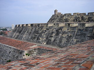
The Castillo San Felipe de Barajas is a fortress in the city of Cartagena, Colombia. The castle was built in 1536 and is located on the Hill of San Lázaro in a strategic location, dominating approaches to the city by land or sea. It was originally known as the Castillo de San Lázaro. It was built by African slave labor under Spanish supervision during the colonial era. The fortress was involved in several battles between the late 17th to early 19th centuries between European powers.
The following is a timeline of the history of the city of Cartagena de Indias, Colombia.

The Walls of Felipe IV surrounded the city of Madrid between 1625 and 1868. Philip IV ordered their construction to replace the earlier Walls of Philip II and the Walls del Arrabal, which had already been surpassed by the growth of population of Madrid. These were not defensive walls, but essentially served fiscal and surveillance purposes: to control the access of goods to the city, ensure the collection of taxes, and to monitor who went in and out of Madrid. The materials used for construction were brick, mortar and compacted earth.
The Walls del Arrabal were the third in a set of five walls built around Madrid, now the capital of Spain. There are no remaining ruins of the Walls del Arrabal, leaving some debate as to their extent and the period of their construction. It is possible that the walls were built as early as the 12th century, however they were most likely constructed in 1438. The walls may have been intended to protect people against the plagues that ravaged the city at the time. The walls united the urbanized suburbs of the city and prevented entry of the infected.

The Castle of San Luis de Bocachica, also called Fort St. Louis, was a military fortress that defended Cartagena, Colombia. The Spanish built it in the 17th century. After it suffered war damage in the 18th century, they erected a new coastal fortification, the Castle of San Fernando on the same site.

The Puerta del Reloj, Torre del Reloj or Boca del Puente is the main city gate of the historic center of Cartagena de Indias, in Colombia and the original entrance of the fortified city. It is located between the squares Plaza de Independencia and Plaza de los Coches. The name "Puerta del Reloj" responds to the clock with which it was crowned at the beginning of the 18th century. While the name of Boca del Puente is due to the fact that during the colonial period, a drawbridge was raised at the foot of the channel of San Anastasio, which linked the walled city to the legendary Getsemaní neighborhood. In addition the bridge served like defense of the city, since in case of enemy attack, this one was raised to prevent the access of buccaneers and pirates.

The Baluarte de San Ignacio is a bastion located in Cartagena de Indias, in Colombia. This bastion, originally called the Bastión de los Moros, is located on the side of the House of the Jesuits and is the work of Cristóbal de Roda. It is part of the extensive fortifications built by the Spanish to defend Cartagena de Indias.

The Walls of Old San Juan is a defensive city wall that surrounds the western end of the San Juan Islet, site of the historic district of San Juan, Puerto Rico. This defensive wall system was built between the 16th and 18th centuries to protect the city and the Bay of San Juan, a highly strategic point in the Caribbean. These walls, along with the defensive fortresses in Old San Juan, form part of the UNESCO World Heritage Site-designated San Juan National Historic Site as they are characteristic examples of the historic methods of construction used in military architecture which adapted European designs and techniques to the special conditions of the Caribbean port cities.

The bastioned system of the Spanish city of Badajoz consists of a military fortification formed by a set of defensive walls, city gates, bridges, forts, towers, bastions, hornworks, moats, tunnels and ravelins, among other defensive elements, built between the 17th and 18th centuries, following the defensive construction theories popularized by the French military engineer Sébastien Le Prestre, better known as the Marquis de Vauban, as an extension of a previous defensive enclosure that protected this border town.

The coastal 'fortifications' of Spain in America are the works of military engineering that bear witness to the four hundred years of Spanish presence in America. They were built from northern California to Tierra del Fuego. Their purpose was the defense of port towns against the attack of the fleets of the English, French and Dutch armies, as well as corsairs and pirates.


