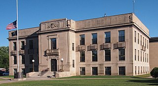
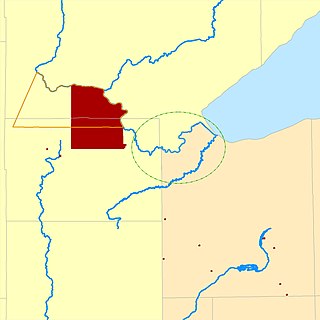
Mille Lacs County is a county in the East Central part of the U.S. state of Minnesota. As of the 2020 census, the population was 26,459. Its county seat is Milaca. The county was founded in 1857, and its boundary was expanded in 1860.

Onamia is a city in Mille Lacs County, Minnesota, United States. The population was 784 as of the 2020 census, down from 878 in 2010. U.S. Highway 169 and Minnesota State Highway 27 are the main routes in the community.

The Rum River is a slow, meandering stream that connects Minnesota's Mille Lacs Lake with the Mississippi River. It runs for 151 miles (243 km) through the communities of Onamia, Milaca, Princeton, Cambridge, Isanti, and St. Francis before ending at the city of Anoka, roughly 20 miles northwest of Minneapolis. It is one of the six protected Wild and Scenic rivers in Minnesota.
Sandy Lake Band of Mississippi Chippewa are a historical Ojibwa tribe located in the upper Mississippi River basin, on and around Big Sandy Lake in what today is in Aitkin County, Minnesota. Though politically folded into the Mille Lacs Band of Ojibwe, thus no longer independently federally recognized, for decades, Sandy Lake Band members have been leading efforts to restore their independent Federal recognition.
The Fond du Lac Indian Reservation is an Indian reservation in northern Minnesota near Cloquet in Carlton and Saint Louis counties. Off-reservation holdings are located across the state in Douglas County, in the northwest corner of Wisconsin. The total land area of these tribal lands is 154.49 square miles (400.1 km2). It is the land-base for the Fond du Lac Band of Lake Superior Chippewa. Before the establishment of this reservation, the Fond du Lac Band of Lake Superior Chippewa were located at the head of Lake Superior, closer to the mouth of the Saint Louis River, where Duluth has developed.

Fond du Lac Band of Lake Superior Chippewa is an Anishinaabe (Ojibwe) band located near Cloquet, Minnesota. Their land base is the Fond du Lac Indian Reservation, located mainly in Carlton and Saint Louis Counties, Minnesota, 20 miles west of Duluth.
Mille Lacs Indian Reservation is the popular name for the land-base for the Mille Lacs Band of Ojibwe in Central Minnesota, about 100 miles (160 km) north of Minneapolis-St. Paul. The contemporary Mille Lacs Band reservation has significant land holdings in Mille Lacs, Pine, Aitkin and Crow Wing counties, as well as other land holdings in Kanabec, Morrison, and Otter Tail Counties. Mille Lacs Indian Reservation is also the name of a formal Indian reservation established in 1855. It is one of the two formal reservations on which the contemporary Mille Lacs Band retains land holdings. The contemporary Mille Lacs band includes several aboriginal Ojibwe bands and villages, whose members reside in communities throughout central Minnesota.

The Mille Lacs Band of Ojibwe, also known as the Mille Lacs Band of Chippewa Indians, is a federally recognized American Indian tribe in east-central Minnesota. The Band has 4,302 members as of 2012. Its homeland is the Mille Lacs Indian Reservation, consisting of District I, District II, District IIa, and District III.
The Minnesota Indian Affairs Council (MIAC) is an intergovernmental body established by the U.S. state of Minnesota to serve as a liaison between state government and the Native American tribes residing within the state's boundaries. Created by the Minnesota Legislature, MIAC aims to improve relationships, facilitate dialogue, and address issues of mutual concern between the State of Minnesota and the tribal governments. The council plays a critical role in advising on policy, advocating for indigenous rights, and promoting cultural understanding.
The Mille Lacs Indians, also known as the Mille Lacs and Snake River Band of Chippewa, are a Band of Indians formed from the unification of the Mille Lacs Band of Mississippi Chippewa (Ojibwe) with the Mille Lacs Band of Mdewakanton Sioux (Dakota). Today, their successor apparent Mille Lacs Band of Ojibwe consider themselves as being Ojibwe, but many on their main reservation have the ma'iingan (wolf) as their chief doodem (clan), which is an indicator of Dakota origins.
Mississippi River Band of Chippewa Indians or simply the Mississippi Chippewa, are a historical Ojibwa Band inhabiting the headwaters of the Mississippi River and its tributaries in present-day Minnesota.
The Mdewakanton or Mdewakantonwan are one of the sub-tribes of the Isanti (Santee) Dakota (Sioux). Their historic home is Mille Lacs Lake in central Minnesota. Together with the Wahpekute, they form the so-called Upper Council of the Dakota or Santee Sioux. Today their descendants are members of federally recognized tribes in Minnesota, South Dakota and Nebraska of the United States, and First Nations in Manitoba, Canada.

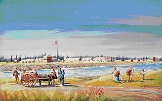
Mille Lacs Kathio State Park, also known as Kathio Site, is a Minnesota state park on Mille Lacs Lake. The park preserves habitation sites and mound groups, believed to date between 3000 BC and 1750 AD, that document Dakota Indian culture and Ojibwe-Dakota relationships. The park contains 19 identified archaeological sites, making it one of the most significant archaeological collections in Minnesota. The earliest site dates to the Archaic period and shows evidence of copper tool manufacture. The Dakota lived in this area roughly until the 18th century, when many bands of them were moving southward into the prairies and river areas of southern Minnesota. At the same time, Ojibwe (Anishinaabe) were moving in from the east. Ojibwe oral tradition, published by William Whipple Warren, suggests that there was a battle in which they successfully took control of the area from the Lakota.
The Lake Superior Chippewa are a large number of Ojibwe (Anishinaabe) bands living around Lake Superior; this territory is considered part of northern Michigan, Wisconsin, and Minnesota in the United States. They migrated into the area by the seventeenth century, encroaching on the Eastern Dakota people who had historically occupied the area. The Ojibwe defeated the Eastern Dakota, who migrated west into the Great Plains after the final battle in 1745. While they share a common culture including the Anishinaabe language, this highly decentralized group of Ojibwe includes at least twelve independent bands in the region.
Lake Lena is an unincorporated community and Native American village in Ogema Township, Pine County, Minnesota, United States, located along the Lower Tamarack River. It currently is the administrative center for the Mille Lacs Indian Reservation, District III.
Treaty of St. Peters may be one of two treaties conducted between the United States and Native American peoples, conducted at the confluence of the Minnesota River with the Mississippi River, in what today is Mendota, Minnesota.
Sandy Lake is an unincorporated community Native American village located in Turner Township, Aitkin County, Minnesota, United States. Its name in the Ojibwe language is Gaa-mitaawangaagamaag, meaning "Place of the Sandy-shored Lake". The village is administrative center for the Sandy Lake Band of Mississippi Chippewa, though the administration of the Mille Lacs Indian Reservation, District II, is located in the nearby East Lake.
Bayaaswaa was the principal Chief of the Sandy Lake Ojibwa, whose village was located at either terminus of the Savanna Portage in Minnesota.
Fort Ripley was a United States Army outpost on the upper Mississippi River, in mid-central Minnesota from 1848 to 1877. It was situated a few miles from the Indian agencies for the Ho-Chunk and Ojibwe in Iowa Territory and then the Minnesota Territory. Its presence spurred immigration into the area and the pioneer settlement of Crow Wing developed approximately 6.75 miles (10.86 km) north of the fort. The post was initially named Fort Marcy. It then was renamed Fort Gaines and in 1850 was renamed again for distinguished Brigadier General Eleazer Wheelock Ripley of the War of 1812. It was the second major military reservation established in what would become Minnesota.
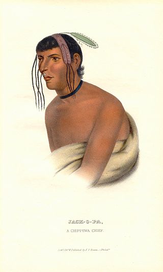
Zhaagobe (c.1794), also known as Jack-O-Pa or Shagobai, was a St. Croix Ojibwe chief of the Snake River band. He signed several Chippewa treaties with the United States, including the 1825 Treaty of Prairie du Chien, the 1826 Treaty of Fond du Lac, the 1837 Treaty of St. Peters, and the 1842 Treaty of La Pointe. In 1836, geographer Joseph Nicollet had an Ojibwe guide he called Chagobay, but historians are uncertain as to whether they were the same person.
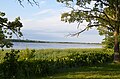 View from Izatys habitation site.
 Izatys habitation site.
