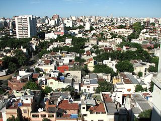
Boedo is a working-class barrio or neighborhood of Buenos Aires, Argentina. The neighborhood and one of its principal streets were named after Mariano Boedo, a leading figure in the Argentine independence.
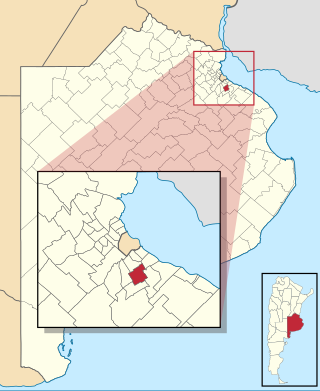
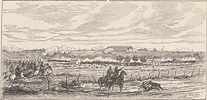
Almirante Brown is a partido of the Buenos Aires Province, Argentina, located at the south of the Gran Buenos Aires urban area, at coordinates 34°47′S58°24′W.

Núñez is a barrio or neighbourhood of Buenos Aires, Argentina. It is on the northern edge of the city on the banks of the Rio de la Plata. The barrio of Belgrano is to the southeast; Saavedra and Coghlan are to the west; and Vicente López, in Buenos Aires Province, is to the north.

Constitución is a barrio or neighborhood of Buenos Aires, Argentina, approximately two kilometers south of downtown.

The National Historical Museum is a museum located in Buenos Aires, Argentina, and is a museum dedicated to the history of Argentina, exhibiting objects relating to the May Revolution and the Argentine War of Independence.

Plaza Miserere is one of the main plazas (squares) of Buenos Aires, Argentina. It is located alongside the Once de Septiembre Station of the Ferrocarril Domingo Faustino Sarmiento in the heart of the Balvanera neighborhood.
Parque Tres de Febrero, popularly known as Bosques de Palermo, is an urban park of approximately 400 hectares located in the neighborhood of Palermo in Buenos Aires, Argentina. Located between Libertador and Figueroa Alcorta Avenues, it is known for its groves, lakes, and rose gardens.

Parque Patricios is a barrio located on the southern side of Buenos Aires, Argentina belonging to the fourth comuna.

Flores is a middle-class barrio or district in the center part of Buenos Aires city, Argentina. Flores was considered a rural area of the Province of Buenos Aires until 1888 when it was integrated into the city. Flores is the birthplace of Pope Francis.

Ciudadela is a city in Greater Buenos Aires, Buenos Aires Province, Argentina. It is located in the Tres de Febrero Partido, immediately to the west of the neighborhood of Liniers in Buenos Aires city proper. It is separated from the city by General Paz avenue.

Mataderos is a barrio (neighbourhood) in Buenos Aires, Argentina. It is one of the three barrios that make up the Comuna 9, alongside Liniers and Parque Avellaneda. Located in the south-west end of the city, it takes its name from the livestock market and various slaughterhouses located within it.

Vélez Sársfield is a barrio or district in the western part of Buenos Aires, Argentina, located in the area defined by the streets Segurola Avenue, Juan Agustín García, Lope de Vega Avenue, Juan B. Justo Ave., Corro Ave., Medina, Juan Bautista Alberdi Ave. and Mariano Acosta.
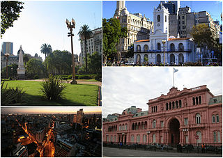
Monserrat or Montserrat is a neighbourhood in the east of the Buenos Aires CBD. The district features some of the most important public buildings in Buenos Aires, including city hall, the city legislature, Casa Rosada, the Colegio Nacional de Buenos Aires and the Libertador Building, among others.
Parque Chacabuco is a neighbourhood in Buenos Aires, Argentina. Its name is due to Chacabuco Park, which is in its centre, taking the name from the Battle of Chacabuco.

Villa Luro is a barrio (district) of Buenos Aires, Argentina. It is located near the western end of the City of Buenos Aires.

Villa Riachuelo is a barrio or neighborhood of Buenos Aires, Argentina. Located at the southernmost end of the city, Villa Riachuelo is bordered by the barrios of Villa Lugano to the north and Villa Soldati to the northeast, the Buenos Aires Province localities of Villa Fiorito and Lanús Oeste to the southeast and Ciudad Madero to the southwest.

Avenida Rivadavia is one of the principal thoroughfares in Buenos Aires, Argentina, extending 23 miles (37 km) from downtown Buenos Aires to the western suburb of Merlo. It is considered the third longest avenue in the world after Yonge Street (Toronto) and Western Avenue (Chicago).
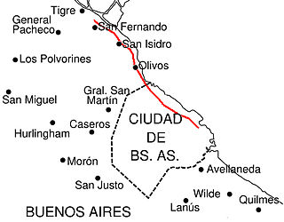
Avenida del Libertador is one of the principal thoroughfares in Buenos Aires, Argentina, and in points north, extending 25 km (16 mi) from the Retiro District of Buenos Aires to the northern suburb of San Fernando.

The Buenos Aires City Legislature is the legislative power of the government of the Autonomous City of Buenos Aires, Argentina. It is housed in the Legislature Palace, an architectural landmark in the barrio of Montserrat.

Plaza Italia is a small park in the city of Buenos Aires in the barrio of Palermo on the confluence of Santa Fe Avenue and Avenida Sarmiento. Next to the plaza are the main entrances to the Zoo and the Botanical Gardens, and the la Rural Expo Center. The area is very busy with traffic, as it is a public transportation hub for the city.