The following is a list of the 345 communes of the Ille-et-Vilaine department of France.

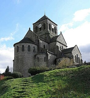
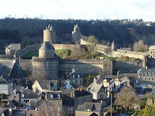
Fougères is a commune and a sub-prefecture of the Ille-et-Vilaine department in the region of Brittany, northwestern France.

Charles Armand Tuffin, marquis de la Rouërie, also known in the United States as "Colonel Armand", was a Breton cavalry officer who served under the American flag during the American War of Independence. He was promoted to brigadier general after the Battle of Yorktown. He is also known as one of the early leaders of the Breton Association during the French Revolution.

The arrondissement of Fougères-Vitré is an arrondissement of France in the Ille-et-Vilaine department in the Brittany region. In 2010 its name was changed to arrondissement of Fougères-Vitré, and it absorbed the six cantons of Argentré-du-Plessis, Châteaubourg, La Guerche-de-Bretagne, Retiers, Vitré-Est and Vitré-Ouest from the arrondissement of Rennes. Since the January 2017 reorganization of the arrondissements of Ille-et-Vilaine, it has 114 communes.

The arrondissement of Rennes is an arrondissement of France in the Ille-et-Vilaine department in the Brittany region. In 2010 it lost the six cantons of Argentré-du-Plessis, Châteaubourg, La Guerche-de-Bretagne, Retiers, Vitré-Est and Vitré-Ouest to the arrondissement of Fougères-Vitré. Since the January 2017 reorganization of the arrondissements of Ille-et-Vilaine, it has 111 communes.

The canton of Saint-Aubin-du-Cormier is a former canton of France, located in the arrondissement of Fougères-Vitré, in the Ille-et-Vilaine département, Brittany region of France. It was disbanded following the French canton reorganisation which came into effect in March 2015. It consisted of 10 communes, which joined the canton of Fougères-1 in 2015.
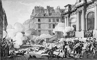
13 Vendémiaire Year 4 is the name given to a battle between the French Revolutionary troops and Royalist forces in the streets of Paris.
The Treaty of Sablé was signed on 20 August 1488 in Sablé between Duke Francis II of Brittany and Charles VIII of France. Based on the terms of the accord, the Duke of Brittany acknowledged himself as a vassal of the King of France. Moreover, the Duke of Brittany pledged the territories of Saint Malo, Dinan, Fougères and Saint-Aubin-du-Cormier to be controlled by the French crown. Also, Francis promised to remove all foreign troops from his territories, as well as ensure to seek Charles's consent before marrying off his daughter, Anne. In return, Charles removed his forces from Brittany except in the town garrisons of the territories pledged by Francis. In another aspect of the treaty, the Duke of Brittany was no longer permitted to summon any troops from England.

The invasion of France in 1795 or the Battle of Quiberon was a major landing on the Quiberon peninsula by émigré, counter-revolutionary troops in support of the Chouannerie and Vendée Revolt, beginning on 23 June and finally definitively repulsed on 21 July. It aimed to raise the whole of western France in revolt, bring an end to the French Revolution and restore the French monarchy. The invasion failed; it had a major negative impact, dealing a disastrous blow to the royalist cause.

Aimé Casimir Marie Picquet, chevalier du Boisguy, sometimes spelt Bois-Guy,, was a French chouan general during the French Revolution. He was nicknamed "the little general" by his men due to his youth. Still a child at the outbreak of the Revolution, he signalled his precocity to fight on the Royalist side, joining the Breton Association at 15 and becoming aide de camp to La Rouërie. At 17 he was made leader of the chouannerie in the pays de Fougères, and a general at 19. Boisguy made the north-east of the Ille-et-Vilaine one of the most active areas of the Breton chouannerie, and showed himself an excellent tactician. Rarely beaten, the chouans there were among the best organised and best disciplined. Fighting in uniform from the end of 1795 and made up of elite troops, even so they suffered from a lack of cavalry and a near-total lack of artillery. The Republicans had to raise major forces to defeat them, and then only with difficulty. In both 1796 and 1800, Boisguy was the last general to surrender, making him one of the main figures of the chouannerie.

The Virée de Galerne was a military operation of the War in the Vendée during the French Revolutionary Wars across Britanny and Normandy. It takes its name from French virée (turn) and Breton gwalarn.
The Canton of Fougères-Sud is a former canton of France, in the Ille-et-Vilaine département, located in the Fougères area. It was disbanded following the French canton reorganisation which came into effect in March 2015.
The battle of Fougères was a battle on 3 November 1793 at Fougères, during the Virée de Galerne. It was a Vendéen victory.
Henri Victor Roulland , or Rouland was a French Brigadier General of the French Revolution and the French Revolutionary Wars. He led the heroic defense of the fortress of Landrecies during the Siege of Landrecies (1794), but was forced to surrender after a devastating artillery bombardment that lasted three days.
The canton of Fougères-1 is an administrative division of the Ille-et-Vilaine department, in northwestern France. It was created at the French canton reorganisation which came into effect in March 2015. Its seat is in Fougères.
The canton of Fougères-2 is an administrative division of the Ille-et-Vilaine department, in northwestern France. It was created at the French canton reorganisation which came into effect in March 2015. Its seat is in Fougères.