The Arctic Archipelago, also known as the Canadian Arctic Archipelago, is a group of islands north of the Canadian mainland.
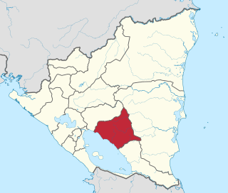
Chontales is a department in Nicaragua. It covers an area of 6,481.27 km² and has a population of 182,000. The capital is Juigalpa.

Santo Tomás is a municipality in the Chontales Department of Nicaragua. It is located 179 km (111 mi) from Managua and 40 km (25 mi) from Juigalpa on the paved highway to Rama, en route to the Atlantic Coast.

Petneháza is a village in Szabolcs-Szatmár-Bereg county, in the Northern Great Plain region of eastern Hungary.
Martínez de la Torre is a city and its surrounding municipality of the same name located in the central part of the Mexican state of Veracruz. The city had a 2005 census population of 56,433, while the municipality had a population of 97,768. There is a total area of 815.13 km² in the municipality. The largest other community in the municipality is the town of Independencia. Martinez de la Torre have the most taxi Service that people use for their daily lives.
El Saucejo is a town in the province of Seville, Spain. As of the 2005 census (INE), the city had a population of 4379.
Peral de Arlanza is a municipality and town located in the province of Burgos, Castile and León, Spain. According to the 2004 census (INE), the municipality has a population of 223 inhabitants.
Horcajo de las Torres is a municipality located in the province of Ávila, Castile and León, Spain. According to the 2004 census (INE), the municipality has a population of 720 inhabitants.
Sauquillo de Cabezas is a municipality located in the province of Segovia, Castile and León, Spain. According to the 2004 census (INE), the municipality has a population of 231 inhabitants.
Mitteldithmarschen is an Amt in the district of Dithmarschen, in Schleswig-Holstein, Germany. Its seat is in Meldorf. It was formed on 25 May 2008 from the former Ämter Kirchspielslandgemeinde Albersdorf, Kirchspielslandgemeinde Meldorf-Land and the town Meldorf.

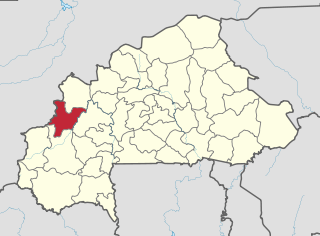
Mawé is a town in the Solenzo Department of Banwa Province in western Burkina Faso. As of 2005 it had a population of 2,329.

Węgiersk is a village in the administrative district of Gmina Golub-Dobrzyń, within Golub-Dobrzyń County, Kuyavian-Pomeranian Voivodeship, in north-central Poland. It lies 5 kilometres (3 mi) south-east of Golub-Dobrzyń and 32 km (20 mi) east of Toruń.
Żebrak is a village in the administrative district of Gmina Skórzec, within Siedlce County, Masovian Voivodeship, in east-central Poland. It lies approximately 17 kilometres (11 mi) south-west of Siedlce and 76 km (47 mi) east of Warsaw.
Łęg is a village in the administrative district of Gmina Śrem, within Śrem County, Greater Poland Voivodeship, in west-central Poland. It lies approximately 4 kilometres (2 mi) east of Śrem and 37 km (23 mi) south of the regional capital Poznań.
Cotati was a 5,963 ton refrigerated cargo ship which was built in 1919. She was renamed Empire Avocet in 1942 and sunk by U-125 on 29 September 1942.
Sourountouna is a small town and commune in the Cercle of San in the Ségou Region of Mali. As of 1998 the commune had a population of 11,107.

Abradasikatte is a village in the southern state of Karnataka, India. It is located in the Holalkere taluk of Chitradurga district in Karnataka.

Malé Kyšice is a village and municipality in Kladno District in the Central Bohemian Region of the Czech Republic.
Aramari, Bahia is a municipality in the state of Bahia in the North-East region of Brazil.

Rexford Glacier is a glacier flowing northeast into the head of Wagoner Inlet on the north side of Thurston Island. Named by Advisory Committee on Antarctic Names (US-ACAN) after Aviation Radioman Phillip W. Rexford, PBM Mariner aircrewman in the Eastern Group of U.S. Navy Operation Highjump, which obtained aerial photographs of this glacier and adjoining coastal areas, 1946-47.