The Arctic Archipelago, also known as the Canadian Arctic Archipelago, is a group of islands north of the Canadian mainland.

The Boeing 717 is a twin-engine, single-aisle jet airliner, developed for the 100-seat market. The airliner was designed and originally marketed by McDonnell Douglas as the MD-95, a derivative of the DC-9 family. Capable of seating up to 134 passengers, the 717 has a design range of 2,060 nautical miles (3,820 km). It is powered by two Rolls-Royce BR715 turbofan engines mounted at the rear of the fuselage.
Littleworth is a hamlet in the parish of Wing, in Buckinghamshire, England. It is situated between the main village and the hamlet of Burcott.
Navascués is a town and municipality in the province and autonomous community of Navarre in northern Spain. It has a population of under 200.

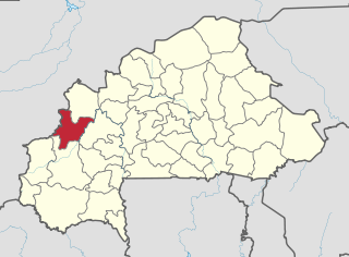
Méguet is a town in the Méguet Department in Ganzourgou Province in central Burkina Faso. The population of Méguet is 7,273 and it is the capital of Méguet Department.
Burns Lake Park is a provincial park in British Columbia, Canada, located near the town of Burns Lake. The park was established per Order in Council 63 on 25 January 2001, and constitutes fewer than 65 hectares.
Totanés is a municipality located in the province of Toledo, Castile-La Mancha, Spain. According to the 2006 census (INE), the municipality had a population of 417 inhabitants.

Cabezas del Villar is a municipality located in the province of Ávila, Castile and León, Spain. According to the 2006 census (INE), the municipality has a population of 399 inhabitants.

Valle de Hecho is a municipality located in the province of Huesca, Aragon, Spain. According to the 2004 census (INE), the municipality has a population of 984 inhabitants.
Pleitas is a municipality located in the province of Zaragoza, Aragon, Spain. According to the 2004 census (INE), the municipality has a population of 62 inhabitants.
Valverde de Júcar is a municipality located in the province of Cuenca, Castile-La Mancha, Spain. According to the 2016 census (INE), the municipality has a population of 1,173 inhabitants.
Sacañet is a municipality in the comarca of Alto Palancia, Castellón, Valencia, Spain.
Zigla-Koulpele is a town in the Garango Department of Boulgou Province in south-eastern Burkina Faso. As of 2005, the town has a population of 4,476.
Boko is a town in the Niangoloko Department of Comoé Province in south-western Burkina Faso. The town has a population of 2,633.

The 1968 Open Championship was the 97th Open Championship, played 10–13 July at Carnoustie Golf Links in Angus, Scotland. Gary Player won the second of his three Open titles, two strokes ahead of runners-up Bob Charles and Jack Nicklaus. It was the fifth of Player's nine major titles.
This is a list of the extreme points and extreme elevations in Scotland.
Massougou is a town in the Boussouma Department of Boulgou Province in south-eastern Burkina Faso. As of 2005, the town has a population of 325.
German submarine U-962 was a Type VIIC U-boat built for Nazi Germany's Kriegsmarine during World War II. Her keel was laid at the yards of Blohm & Voss in Hamburg on 7 April 1942. Launched on 17 December 1942, she was formally commissioned on 11 February 1943 and given to Oblt.z.S. Ernst Liesberg, who commanded the submarine on both of her active war patrols.
German submarine U-717 was a Type VIIC U-boat of Nazi Germany's Kriegsmarine during World War II. The submarine was laid down on 24 April 1942 at the H. C. Stülcken Sohn yard at Hamburg, launched on 20 February 1943, and commissioned on 19 May 1943 under the command of Oberleutnant zur See Siegfried von Rothkirch und Panthen. Attached to 5th U-boat Flotilla based at Kiel, U-717 completed her training period on 31 July 1944 and was assigned to front-line service.