The Tiriyó are a Amerindian ethnic group native to parts of northern Brazil and Suriname. In 2005, there were approximately 2,000 Tiriyó in the two countries. They live in several major villages and a number of minor villages in the border zone between Brazil and Suriname. They speak the Tiriyó language, a member of the Cariban language family and refer to themselves as tarëno, etymologically 'people from here' or 'local people'.

Stone Quarry Mills is a small unincorporated community in Spiceland Township, Henry County, Indiana, United States.
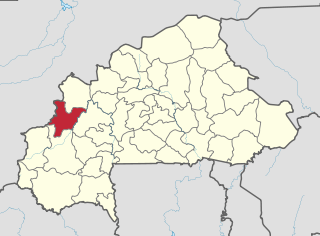
Gombio is a village in the Sanaba Department of Banwa Province in western Burkina Faso. As of 2005 it had a population of 292.
Yenkuy is a village in the Sanaba Department of Banwa Province in western Burkina Faso. As of 2005, it had a population of 278.

Michalin is a village in the administrative district of Gmina Waganiec, within Aleksandrów County, Kuyavian-Pomeranian Voivodeship, in north-central Poland. It lies approximately 3 kilometres (2 mi) south-west of Waganiec, 12 km (7 mi) south-east of Aleksandrów Kujawski, and 30 km (19 mi) south-east of Toruń.
Wiktoryn is a village in the administrative district of Gmina Waganiec, within Aleksandrów County, Kuyavian-Pomeranian Voivodeship, in north-central Poland. It lies approximately 3 kilometres (2 mi) south-west of Waganiec, 12 km (7 mi) south-east of Aleksandrów Kujawski, and 30 km (19 mi) south-east of Toruń.
Młynów is a village in the administrative district of Gmina Piątek, within Łęczyca County, Łódź Voivodeship, in central Poland. It lies approximately 3 kilometres (2 mi) south-west of Piątek, 19 km (12 mi) east of Łęczyca, and 30 km (19 mi) north of the regional capital Łódź.
Stok is a village in the administrative district of Gmina Ulan-Majorat, within Radzyń Podlaski County, Lublin Voivodeship, in eastern Poland. It lies approximately 4 kilometres (2 mi) north of Ulan-Majorat, 13 km (8 mi) north-west of Radzyń Podlaski, and 66 km (41 mi) north of the regional capital Lublin.
Chotum is a village in the administrative district of Gmina Ciechanów, within Ciechanów County, Masovian Voivodeship, in east-central Poland. It lies approximately 12 kilometres (7 mi) west of Ciechanów and 83 km (52 mi) north-west of Warsaw.
Tadeuszów is a village in the administrative district of Gmina Pionki, within Radom County, Masovian Voivodeship, in east-central Poland. It lies approximately 3 kilometres (2 mi) south-west of Pionki, 19 km (12 mi) north-east of Radom, and 89 km (55 mi) south of Warsaw.
Rokicie is a village in the administrative district of Gmina Mochowo, within Sierpc County, Masovian Voivodeship, in east-central Poland. It lies approximately 11 kilometres (7 mi) north-west of Mochowo, 15 km (9 mi) west of Sierpc, and 125 km (78 mi) north-west of Warsaw.
Jaczew is a village in the administrative district of Gmina Korytnica, within Węgrów County, Masovian Voivodeship, in east-central Poland. It lies approximately 6 kilometres (4 mi) north of Korytnica, 15 km (9 mi) north-west of Węgrów, and 64 km (40 mi) north-east of Warsaw.
Powązki is a village in the administrative district of Gmina Mszczonów, within Żyrardów County, Masovian Voivodeship, in east-central Poland. It lies approximately 5 kilometres (3 mi) south-west of Mszczonów, 12 km (7 mi) south of Żyrardów, and 47 km (29 mi) south-west of Warsaw.
Nowina is a village in the administrative district of Gmina Lubasz, within Czarnków-Trzcianka County, Greater Poland Voivodeship, in west-central Poland. It lies approximately 5 kilometres (3 mi) south-west of Lubasz, 10 km (6 mi) south-west of Czarnków, and 57 km (35 mi) north-west of the regional capital Poznań.
Sangrave is a town and commune in the Brakna Region of southern Mauritania.
Minty is a village in the administrative district of Gmina Bartoszyce, within Bartoszyce County, Warmian-Masurian Voivodeship, in northern Poland, close to the border with the Kaliningrad Oblast of Russia. It lies approximately 6 kilometres (4 mi) south of Bartoszyce and 52 km (32 mi) north-east of the regional capital Olsztyn.
Mortęgi is a village in the administrative district of Gmina Lubawa, within Iława County, Warmian-Masurian Voivodeship, in northern Poland. It lies approximately 5 kilometres (3 mi) south-west of Fijewo, 19 km (12 mi) south-east of Iława, and 62 km (39 mi) south-west of the regional capital Olsztyn.

Tepetzintla (municipality) is a town and municipality in Puebla in south-eastern Mexico.
Xochiapulco is a municipality in Puebla in south-eastern Mexico.
German submarine U-261 was a Type VIIC U-boat of Nazi Germany's Kriegsmarine during World War II. The submarine was laid down on 17 May 1941 at the Bremer Vulkan yard at Bremen-Vegesack as yard number 26, launched on 16 February 1942 and commissioned on 28 March under the command of Kapitänleutnant Hans Lange. After training with the 8th U-boat Flotilla, U-261 was transferred to the 6th U-boat Flotilla, for front-line service from 1 September 1942.