Bayly's Cove was on Bonavista Bay and had a population of 900 in 1911.
Bayly's Cove was on Bonavista Bay and had a population of 900 in 1911.
Coordinates: 48°39′N53°07′W / 48.650°N 53.117°W
| | This Newfoundland and Labrador location article is a stub. You can help Wikipedia by expanding it. |

Eastport is a long-popular Newfoundland vacation destination on the Eastport Peninsula. Eastport is located on the north-eastern border of Terra Nova National Park and is known for its sandy beaches, scenery and traditional Newfoundland outport heritage.
Eagle Bay Provincial Park is a provincial park in British Columbia, Canada which covers 262 hectares of land.
Little Andrews Bay Marine Provincial Park is a provincial park in British Columbia, Canada, located on Ootsa Lake in the Nechako Country in that province's Central Interior. It is 102 ha. in size.
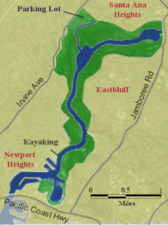
The Upper Newport Bay is a large coastal wetland in Newport Beach, Southern California and a major stopover for birds on the Pacific Flyway. Dozens of species, including endangered ones, can be observed here. Upper Newport Bay Nature Preserve and Ecological Reserve represent approximately 1,000 acres (4 km2) of open space. The Upper Newport Bay was purchased by the state in 1975 for its Fish and Wildlife Department's Ecological Reserve System. In 1985 the upper west bluffs and lands surrounding the bay became part of an Orange County regional park, which offers outdoor activities such as bird-watching, jogging, bicycling, hiking, and kayaking. The Peter and Mary Muth Interpretive Center, located at 2301 University Drive, is open to the public Tuesday through Sunday from 10:00 AM to 4:00 PM. An organization known as the Newport Bay Conservancy (NBC) provides volunteers to answer visitors' questions and guide them through the various activities.
The Artificial Reef Society of British Columbia (ARSBC) is a registered non-profit society based in Vancouver, British Columbia (BC), and is a registered tax-deductible charity in Canada.
The Fiddle Range is a mountain range of the Canadian Rockies located south of Highway 16 on the east border of Jasper National Park, Canada.

Trefacio is a municipality located in the province of Zamora, Castile and León, Spain. According to the 2004 census (INE), the municipality has a population of 247 inhabitants.

Salvage is a town located on the Eastport Peninsula of the Canadian province of Newfoundland and Labrador. The town had a population of 108 in the Canada 2021 Census.
Trinity Bay North is a town in the Canadian province of Newfoundland and Labrador. It is located at the northern tip of Trinity Bay. The town had a population of 1,649 in the Canada 2021 Census.
Wenaha National Forest was established as the Wenaha Forest Reserve by the U.S. Forest Service in Oregon and Washington on May 12, 1905 with 731,650 acres (2,960.9 km2). It became a National Forest on March 4, 1907. On November 5, 1920 the entire forest was transferred to Umatilla National Forest and the name was discontinued.
This is a list of the extreme points and extreme elevations in Wales.
Ostrowin is a village in the administrative district of Gmina Ostróda, within Ostróda County, Warmian-Masurian Voivodeship, in northern Poland. It lies approximately 12 kilometres (7 mi) south-east of Ostróda and 30 km (19 mi) south-west of the regional capital Olsztyn.

The Institute of Ocean Sciences is operated by Fisheries and Oceans Canada and is one of the largest marine research centres in Canada. It is located on Patricia Bay and the former British Columbia Highway 17A in Sidney, British Columbia on Vancouver Island just west of Victoria International Airport.
Sweet Bay is a settlement in Newfoundland and Labrador. It was settled sometime in the early 1800s, primarily as a fishing settlement.
Schrader Glacier is a small glacier which flows to the head of Wilson Harbour on the south coast of South Georgia. Charted by the German Antarctic Expedition under Wilhelm Filchner, 1911–12, and named for Dr. K. Schrader, leader of the German group of the International Polar Year Investigations based at Royal Bay in 1882–83.
Upper Newport Bay State Marine Conservation Area (SMCA) is a marine protected area in Newport Bay in Orange County and the South Coast region of Southern California. It extends inland/northeast from the Pacific Coast Highway crossing of the bay, within the city of Newport Beach.

Division No. 1, Subdivision G is an unorganized subdivision on the Avalon Peninsula in Newfoundland and Labrador, Canada. It is in Division 1 and contains the unincorporated communities of Baccalieu Island, Besom Cove, Bradley's Cove, Burnt Point, Caplin Cove, Daniel's Cove, Grates Cove, Gull Island, Job's Cove, Kingston, Long Beach, Lower Island Cove, Low Point, Northern Bay, Ochre Pit Cove, Red Head Cove, Riverhead, Smooth Cove and Western Bay.