Bayou Cemetery, Illinois

Last updated
Bayou Cemetery
Bayou Cemetery, Illinois
Details
Location
CountryUnited States

Bayou Cemetery (also known as Reynolds Cemetery) is located southwest of Cornell at the southeast intersection of the Bayou and the Vermilion River in section 22 of Amity Township, Livingston County, Illinois, United States. [1] The Bayou is the name given to the sometimes dry stream that flows between the Vermilion River and Rooks Creek when both are flooded.

History

Bayou Cemetery is the final resting place of several area pioneer families. Burials date back to Margaret Winters Reynolds, the first European buried in what later became Amity Township, in 1838. [2] through the early 20th century.

The cemetery appears nameless as "Cem." on the 1911 map of Amity Township and looks to be on property owned by either Jas. Corrigan or J. L. Gourley (the property line is hand drawn and not clear).

The 1930 to 1952 maps of Amity Township all list it as "Cem." and show it as being on the property of K. Gourley. [3] [4] [5] [6]

The 1972 township directory does not show the cemetery or property borders. [7]

Related Research Articles

<span class="mw-page-title-main">Menominee County, Michigan</span> County in Michigan, United States

Menominee County is a county located in the Upper Peninsula in the U.S. state of Michigan. As of the 2020 census, the population was 23,502. The county seat is Menominee. The county's name comes from an American Indian word meaning "wild rice eater" used to describe a tribe. The county was created in 1861 from area partitioned out of Delta County, under the name of Bleeker. When county government was organized in 1863, the name was changed to Menominee.

<span class="mw-page-title-main">Vermilion County, Illinois</span> County in Illinois, United States

Vermilion County is a county in the eastern part of the U.S. state of Illinois, between the Indiana border and Champaign County. It was established in 1826 and was the 45th of Illinois' 102 counties. According to the 2020 United States census, it had a population of 74,188. It contains 21 incorporated settlements; the county seat and largest city is Danville.

<span class="mw-page-title-main">Livingston County, Illinois</span> County in Illinois, United States

Livingston County is a county located in the U.S. state of Illinois. According to the 2020 census, it has a population of 35,815. Its county seat is Pontiac. Livingston County comprises the Pontiac, IL Micropolitan Statistical Area, which is combined with the Bloomington–Normal metropolitan statistical area as the Bloomington-Pontiac, IL Combined Statistical Area in upper portion of Central Illinois.

<span class="mw-page-title-main">Iroquois County, Illinois</span> County in Illinois, United States

Iroquois County is a county located in the northeast part of the U.S. state of Illinois. According to the 2020 United States Census, it has a population of 27,077. It is the only county in the United States to be named Iroquois, after the American Indian people. The county seat is Watseka. The county is located along the border with Indiana.

<span class="mw-page-title-main">Pontiac, Illinois</span> City in Illinois, United States

Pontiac is a city in Livingston County, Illinois, United States. The population was 11,150 at the 2020 Census. It is the county seat of Livingston County. The 1984 movie Grandview, U.S.A. was set in Pontiac.

Saline may refer to:

<span class="mw-page-title-main">Vermilion River (Illinois River tributary)</span> River

The Vermilion River is a 74.8-mile-long (120.4 km) tributary of the Illinois River in the state of Illinois, United States. The river flows north, in contrast to a second Vermilion River in Illinois, which flows south to the Wabash River. The Illinois and Wabash rivers each have a tributary named the Little Vermilion River as well.

<span class="mw-page-title-main">St. Joseph Township, Williams County, Ohio</span> Township in Ohio, United States

St. Joseph Township is one of the twelve townships of Williams County, Ohio, United States. The 2020 census found 2,666 people in the township.

<span class="mw-page-title-main">Knights Landing, California</span> Census-designated place in California, United States

Knights Landing is a census-designated place in Yolo County, California, United States, founded by William Knight. It is located on the Sacramento River around 25 miles northwest of Sacramento in the northeastern portion of the county. Knights Landing's ZIP Code is 95645 and its area code 530. It lies at an elevation of 36 feet. The 2010 census reported that Knights Landing had a population of 995.

<span class="mw-page-title-main">Butler Township, Vermilion County, Illinois</span> Township in Illinois, United States

Butler Township is a township in Vermilion County, Illinois, USA. As of the 2010 census, its population was 992 and it contained 459 housing units.

<span class="mw-page-title-main">Danville Township, Vermilion County, Illinois</span> Township in Illinois, United States

Danville Township is a township in Vermilion County, Illinois, USA. As of the 2010 census, its population was 32,113 and it contained 13,913 housing units. Danville Area Community College and the Illinois Department Of Corrections Danville Correctional Facility are in this township.

<span class="mw-page-title-main">Amity Township, Livingston County, Illinois</span> Township in Illinois, United States

Amity Township is located in Livingston County, Illinois. As of the 2010 census, its population was 866 and it contained 376 housing units.

<span class="mw-page-title-main">Avoca Township, Livingston County, Illinois</span> Township in Illinois, United States

Avoca Township is located in Livingston County, Illinois. As of the 2010 census, its population was 405 and it contained 149 housing units.

<span class="mw-page-title-main">Danville, Illinois</span> City in Illinois, United States

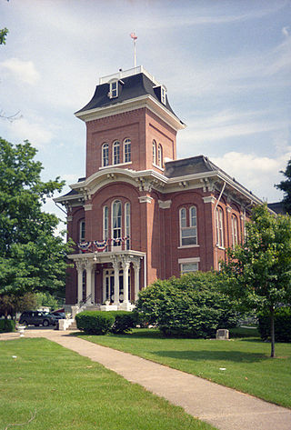
Danville is a city in and the county seat of Vermilion County, Illinois, United States. As of the 2020 census, its population was 29,204. It is the principal city of the Danville metropolitan area.

<span class="mw-page-title-main">Lost Springs Township, Marion County, Kansas</span> Township in Kansas, United States

Lost Springs Township is a township in Marion County, Kansas, United States. As of the 2010 census, the township population was 197, including the city of Lost Springs.

<span class="mw-page-title-main">Centre Township, Marion County, Kansas</span> Township in Kansas, United States

Centre Township is a township in Marion County, Kansas, United States. As of the 2010 census, the township population was 479, not including the city of Marion.

Fisk is an unincorporated community or ghost town in Adair County, Iowa, United States.

<span class="mw-page-title-main">Leat, Nebraska</span> Unincorporated community in Nebraska, U.S.

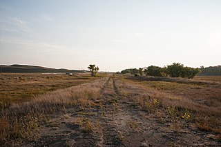
Leat is an unincorporated community in Cherry County, Nebraska, United States.

Baldwin Lake is located in Waterford Township, Michigan. The 9-acre lake lies north and west of Cooley Lake Road and east of Lochaven Road. At its deepest point, the spring-fed lake is 10 feet deep.

Rooks Creek is a tributary of the Vermilion River, an Illinois River tributary, in Illinois. It flows through Rooks Creek Township and runs through the property formerly occupied by Bayou Bluffs Campground in Amity Township in Livingston County, Illinois, before emptying into the Vermilion River south of Cornell.

References

  1. "Amity Township, Cornell." Livingston County, 1911, Geo. A Ogle & Co, Historic Map Works, http://www.historicmapworks.com/Map/US/220542/Amity+Township++Cornell/Livingston+County+1911/Illinois/, retrieved 03 October 2019.
  2. “Amity Township.”. The History of Livingston County, Illinois, Wm Le Baron, Jr & Co, 1878, Chicago. 404-415. Print.
  3. "Amity Township, Cornell, Vermilion River.". Livingston County, 1930c, W. W. Hixson & Company, Historic Map Works, http://www.historicmapworks.com/Map/US/1574230/Amity+Township++Cornell++Vermillion+River/Livingston+County+1930c/Illinois/, retrieved 03 October 2019.
  4. "Amity Township, Cornell, Vermilion River.". Livingston County 1935c, W. W. Hixson & Co., Historic Map Works, http://www.historicmapworks.com/Map/US/1577997/Amity+Township++Cornell++Vermilion+River/Livingston+County+1935c/Illinois/, retrieved 03 October 2019.
  5. "Amity Township, Cornell." Livingston County 1950c, Lawson's Atlases & Plat Books., Historic Map Works, http://www.historicmapworks.com/Map/US/224738/Amity+Township++Cornell/Livingston+County+1950c/Illinois/ retrieved 03 October 2019.
  6. "Amity Township, Cornell, Vermilion River." Livingston County 1952, Lawson's Atlases & Plat Books., Historic Map Works, http://www.historicmapworks.com/Map/US/72027/Amity+Township++Cornel++Vermilion+River/Livingston+County+1952+Revised+1957+Handwritten/Illinois/, retrieved 03 October 2019.
  7. "Amity T29M-R4E." Livingston County 1972, Directory Service Company, Historic Map Works, http://www.historicmapworks.com/Map/US/517714/Amity+T29N+R4E/Livingston+County+1972/Illinois/, retrieved 04 October 2019.

40°58′19″N88°44′51″W / 40.9719°N 88.7476°W / 40.9719; -88.7476