Related Research Articles

Strategic Air Command (SAC) was a United States Department of Defense Specified Command and a United States Air Force (USAF) Major Command responsible for command and control of the strategic bomber and intercontinental ballistic missile components of the United States military's strategic nuclear forces from 1946 to 1992. SAC was also responsible for strategic reconnaissance aircraft; airborne command posts; and most of the USAF's aerial refueling aircraft.

Kincheloe Air Force Base was a United States Air Force (USAF) base during the Cold War. Built in the Upper Peninsula of Michigan in 1943 during World War II, the base was in service until 1977.

Big Rock Point was a nuclear power plant near Charlevoix, Michigan, United States. Big Rock operated from 1962 to 1997. It was owned and operated by Consumers Power, now known as Consumers Energy. Its boiling water reactor was made by General Electric (GE) and was capable of producing 67 megawatts of electricity. Bechtel Corporation was the primary contractor.
Ground-directed bombing (GDB) is a military tactic for airstrikes by ground-attack aircraft, strategic bombers, and other equipped air vehicles under command guidance from aviation ground support equipment and/or ground personnel. Often used in poor weather and at night, the tactic was superseded by an airborne computer predicting unguided bomb impact from data provided by precision avionics Equipment for radar GDB generally included a combination ground radar/computer/communication system and aircraft avionics for processing radioed commands.

The 1st Combat Evaluation Group was a Strategic Air Command (SAC) unit. It was formed on 1 August 1961 to merge the 3908th Strategic Standardization Group for SAC aircrew evaluation with the 1st Radar Bomb Scoring Group that had originated from the 263rd Army Air Force Base Unit which transferred from 15th AF to directly under Strategic Air Command c. 1946. The 1CEVG formed after SAC switched to low-level tactics to counter Soviet surface-to-air missiles and SAC had "developed a Radar Bomb Scoring field kit for use in NIKE Systems" in early 1960 for scoring SAC training missions against US Hercules SAM sites. The 1CEVG headquarters included an Office of History and a "standardization and evaluation school" for command examiners.

The Reeves AN/MSQ-77 Bomb Directing Central, Radar was a United States Air Force automatic tracking radar/computer system for command guidance of aircraft. It was often used during Vietnam War bomb runs at nighttime and during bad weather. Developed from the Reeves AN/MSQ-35, the AN/MSQ-77 reversed the process of Radar Bomb Scoring by continually estimating the bomb impact point before bomb release with a vacuum tube ballistic computer. Unlike "Course Directing Centrals" which guided aircraft to a predetermined release point, the AN/MSQ-77 algorithm continuously predicted bomb impact points during the radar track while the AN/MSQ-77's control commands adjusted the aircraft course. A close air support regulation prohibited AN/MSQ-77 Combat Skyspot bombing within 1,000 yd (910 m) of friendly forces unless authorized by a Forward Air Controller, and "on several occasions" strikes were as close as 273 yd (250 m).
Radar Bomb Scoring is a combat aviation ground support operation used to evaluate Cold War aircrews' effectiveness with simulated unguided bomb drops near radar stations of the United States Navy, the USAF Strategic Air Command, and Army Project Nike units. USAF RBS used various ground radar, computers, and other electronic equipment such as jammers to disrupt operations of the bomber's radar navigator, AAA/SAM simulators to require countermeasures from the bomber, and Radar Bomb Scoring Centrals for estimating accuracy of simulated bombings. Scores for accuracy and electronic warfare effectiveness were transmitted from radar sites such as those at Strategic Range Training Complexes.
The Reeves AN/MSQ-35 Bomb Scoring Central was a United States Air Force dual radar system with computerized plotting board. It was used by the 1st Combat Evaluation Group to evaluate the accuracy of Strategic Air Command bomber crews.
Combat Skyspot was the ground-directed bombing (GDB) operation of the Vietnam War by the United States Air Force using Bomb Directing Centrals and by the United States Marine Corps using Course Directing Centrals. Combat Skyspot's command guidance of B-52s and tactical fighters and bombers—"chiefly flown by F-100's"—at night and poor weather was used for aerial bombing of strategic, close air support, interdiction, and other targets. Using a combination radar/computer/communications system at operating location in Southeast Asia, a typical bombing mission had an air command post turn over control of the mission to the radar station, and the station provided bomb run corrections and designated when to release bombs.

The Badlands Bombing Range (BBR) refers to Rapid City Army Air Base target ranges for World War II which included the current Air Force Retained Area, an inactive 2,486-acre (10.06 km2) United States Air Force site "20 miles southeast" of Scenic, South Dakota. The retained area is the remainder of 341,726 acres (1,382.92 km2) federally acquired in 1942 under eminent domain at the Pine Ridge Indian Reservation. In addition to use by World War II aircraft, BBR was used for a post-war Army National Guard gunnery range and a Cold War Radar Bomb Scoring site.

The 99th Range Group is an inactive United States Air Force (USAF) unit. It was last stationed at Nellis AFB, Nevada, where it was responsible for the Nevada Test and Training Range (NTTR).
The Stockton Ordance Depot was a World War II vehicle repair facility, supply depot, and camp for German and Italian prisoners of war. The installation was also used as a USAF radar station and a DLA Defense Distribution Center.

Hawthorne Bomb Plot is a Formerly Used Defense Site that had a Strategic Air Command (SAC) AUTOTRACK radar station during the Cold War. Operations began at a temporary RBS train site for RBS Express #2 was at the Hawthorne area in December 1961, and the 11th Radar Bomb Scoring Squadron subsequently established the fixed military installation for Radar Bomb Scoring in Babbitt, Nevada, the military housing community near the local Navy/Army depot.
The Salt Lake City Radar Bomb Scoring Site is a Formerly Used Defense Site that was an automatic tracking (AUTOTRACK) radar station during the Cold War. Operated by Detachment 6 of the 11th Radar Bomb Scoring Squadron which had relocated from the Phoenix semi-mobile RBS station in December 1964, the military installation evaluated practice bomb runs by Strategic Air Command simulating attacks on the metropolitan area and on the Hill Air Force Range which had been the Salt Lake City Army Air Base Gunnery Range in World War II.
The Interior Radar Bomb Scoring Site opened in August 1960 on Hurley Butte, adjacent to the Pine Ridge Indian Reservation and a few miles from Interior, South Dakota. The Interior RBSS is a Formerly Used Defense Site, that closed in 1968.
The 3903rd Radar Bomb Scoring Group was a military evaluation unit under direct command of Strategic Air Command (SAC) headquarters for scoring simulated bomb runs using automatic tracking radar stations. Initially an Army Air Forces Base Unit (AAFBU) and then a squadron, the 3903rd RBS Group was personnel, assets, and detachments were redesignated the 1st Radar Bomb Scoring Group and then the 1CEVG Radar Bomb Scoring Division when the RBS Group merged with the 3908th Strategic Standardization Group in 1961, the year RBS Express trains began to be used for low-altitude Boeing B-52 Stratofortress operations..
The Louis Blotner Radar Site was a tracking site site in Connor, Maine at the former NIKE missile launch site. Activated in June 1963 and operational until after 1979, The Ashland site was an AUTOTRACK radar site operated by Detachment 7 of the 1st Combat Evaluation Group. The station simulated Electronic Countermeasures and Radar Bomb Scoring for the Ashland Training Range's low-level training route "over Bangor north to Houlton, Maine."

Fairfax Field was a wartime (WWII) facility of the United States Army Air Forces and later, the United States Air Force. The installation was north of Kansas City, Kansas. Used as a pre-war Naval Air Station, the United States Army Air Forces leased the municipal airfield and built an Air Force Plant and modification center for North American B-25 Mitchell medium bomber production. Military use of the site continued as late as 1957 by the Strategic Air Command's 3903rd Radar Bomb Scoring Group for bombing practice.
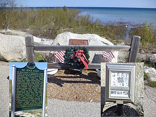
On January 7, 1971, a Boeing B-52C Stratofortress of Strategic Air Command crashed into northern Lake Michigan at the mouth of Little Traverse Bay near Charlevoix, Michigan, while on a low-level training flight. All nine crew members aboard were lost. No remains of the crewmen were recovered. Parts of the aircraft were retrieved from a water depth of 225 feet (69 m) in May and June 1971. The structural remains included parts of the wings, all eight engines, the tail, crew section, landing gear and wheels, plus numerous smaller parts of the plane. Oceans Systems, a Florida-based salvage company, carried out the recovery mission.
Ashland Radar Station was a United States Air Force station located in Ashland, Maine operational from around 1975 to 1990. Sitting on 6.59 acres (2.67 ha).
References
- ↑ "CSSMM Explanation Of Data" (PDF). Archived from the original (PDF) on 2013-11-05. Retrieved 2014-01-07.
- ↑ Defense Manpower Data Center Domain Values for Military Personnel Data Extracts (PDF), DoD, July 28, 2009, DoD Manual 1336.05-M, archived from the original (PDF) on Dec 24, 2010
- ↑ "38 years ago, B-52 crash claimed nine lives near former Big Rock Point - Petoskey News". Archived from the original on 2014-02-01. Retrieved 2013-03-31.
- ↑ The 1961 Charlevoix B-52 crash was the basis for the case study of the hypothetical "Harperville Radar Bomb Scoring facility" with Oil Burner route near a fictional Trinon nuclear plant.
- ↑ "Contact Information". Archived from the original on 2012-01-28. Retrieved 2012-07-17.
- ↑ "Guam Crew Will Staff U.P. Radar". The Milwaukee Sentinel . March 3, 1960. Retrieved 2012-07-09.[ permanent dead link ]
- ↑ https://news.google.com/newspapers?id=zXxRAAAAIBAJ&sjid=9A8EAAAAIBAJ&pg=7157,5158421&dq=bomb-scoring-unit&hl=en [ dead link ]
46°27′N90°8′W / 46.450°N 90.133°W
| | This United States military article is a stub. You can help Wikipedia by expanding it. |