
Batroun, ancient Botrys, is a coastal city in northern Lebanon and one of the oldest continuously inhabited cities in the world. It is the capital city of Batroun District.
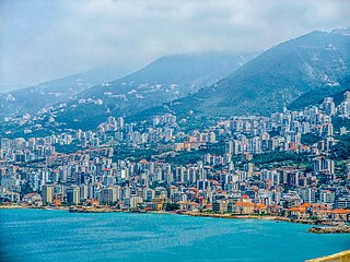
Jounieh is a coastal city in Keserwan District, about 16 km (10 mi) north of Beirut, Lebanon. Since 2017, it has been the capital of Keserwan-Jbeil Governorate. Jounieh is known for its seaside resorts and bustling nightlife, as well as its old stone souk, ferry port, paragliding site and gondola lift, which takes passengers up the mountain to the shrine of Our Lady of Lebanon in Harissa.

Deir al-Qamar is a city south-east of Beirut in south-central Lebanon. It is located five kilometres outside of Beiteddine in the Chouf District of the Mount Lebanon Governorate at 800 m of average altitude.

Amioun is the capital of the predominantly Greek Orthodox Koura District in North Lebanon.

Ehden is a mountainous city in the heart of the northern mountains of Lebanon and on the southwestern slopes of Mount Makmal in the Mount Lebanon Range. Its residents are the people of Zgharta, as it is within the Zgharta District.

Qurnat as Sawdā (Arabic: القرنة السوداء) is the highest point in Lebanon and the Levant, at 3,088 m (10,131 ft) above sea level. It is found at the peak of Jabal al Makmel, a mountain range in the Bsharri District, North Lebanon.
Bdadoun, is a town in Mount Lebanon which makes up one of the 70 towns and villages in the Lebanese district of Aley. It has an estimated population of 3,000. It is 499 meters above sea level and 15 kilometres from the capital Beirut. It is known as a summer holiday location.
The tourism industry in Lebanon has been important to the local economy historically and comprises a major source of revenue for the country.

Rashaya, Rachaya, Rashaiya, Rashayya or Rachaiya, also known as Rashaya al-Wadi or Rachaya el-Wadi, is a town of the Rashaya District in the west of the Beqaa Government of Lebanon. It is situated at around 1,200 metres (3,900 ft) above sea level on the western slopes of Mount Hermon, south east of Beirut near the Syrian border, and approximately halfway between Jezzine and Damascus.

The Mseilha Fort is a fortification situated north of the village of Hamat in Lebanon. The current fort was built by Emir Fakhreddine II in the 17th century to guard the route from Tripoli to Beirut. The fort is built on a long, narrow limestone rock near the Nahr el-Jawz River. Its walls are constructed with small sandstone blocks quarried from the nearby coast and built onto the edge of the limestone rock. The thickness of the walls ranges from 1.5 to 2 meters. The larger limestone blocks are the only remains of an earlier structure probably built for the same defensive reason.

Bdebbaبدبا is a village in Koura District of Lebanon. It has a Maronite and Greek Orthodox population.

Ejdabrine, Ejd Aabrine,, is a Sunni Muslim and Maronite Christian community in the Koura District of Lebanon. Both religions coexist peacefully. It is beautiful and lush, and the jaouzriver surrounds it.
Ajaltoun is a town and municipality in the Keserwan District of the Keserwan-Jbeil Governorate in Lebanon. It is located 24 km north of Beirut. Ajaltoun's average elevation is 850 meters (2800') above sea level and its total land area is 612 hectares. The municipality consists of a twelve-member council, which as of 2008 was headed by Clovis el Khazen. In addition to the municipal council, two mukhtars (headmen), Georges Fersan and Antoine Harouni, also serve the town. The Virgin Mary Church, built by the Khazen sheikhs in 1647, the Saint Nicolas Church and the Mar Shalita Monastery are located in Ajaltoun. The town was also the site of fighter plane crash during World War I.

The Sisters Olive Trees of Noah are a grove of sixteen olive trees in the Lebanese town of Bcheale.

Katzrin is an Israeli settlement organized as a local council in the Golan Heights. Known as the "capital of the Golan", it is the second-largest locality there after Majdal Shams, and the largest Israeli settlement. In 2022 it had a population of 7,876. It is the seat of Golan Regional Council.

El Hedd is a village in Akkar Governorate, Lebanon. The villagers are Maronites.

Jeddayel is a town in the Byblos District of the Keserwan-Jbeil Governorate, Lebanon. It is located 4 km north of Byblos. Its inhabitants are predominantly Greek Orthodox and Maronite Christians. Its population is about 1,500.
Toula is a village in Batroun District, North Governorate, Lebanon, 15 km far from Batroun. Situated at an altitude ranging from 460 meters above sea level at its lowest point, to 760 metres. It is known for its olive oil and figs. The residents are Christians. Its St-Doméce's parish church dates back to 1270, it was restored in 1921 and has beautiful stone vaults inside. There are also the Slayyeb church and Mar Aabda's church.

Bkassine, Beit Kassin, is a village in Lebanon surrounded by the Bkassine Pine Forest. The village is near Jezzine.
Hardîne, sometimes written Ḩardīn, is a village in Batroun District, North Lebanon Governorate, Lebanon. Notable structures include the Temple of Mercury, severely damaged by an earthquake, and several Christian churches and monasteries.


