Related Research Articles

Glynn County is located in the southeastern part of the U.S. state of Georgia. As of the 2010 census, the population was 79,626. The county seat is Brunswick. Glynn County is part of the Brunswick, Georgia Metropolitan Statistical Area.

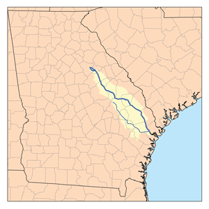
The Altamaha River is a major river in the U.S. state of Georgia. It flows generally eastward for 137 miles (220 km) from its origin at the confluence of the Oconee River and Ocmulgee River towards the Atlantic Ocean, where it empties into the ocean near Brunswick, Georgia. No dams are directly on the Altamaha, though some are on the Oconee and the Ocmulgee. Including its tributaries, the Altamaha River's drainage basin is about 14,000 square miles (36,000 km2) in size, qualifying it among the larger river basins of the US Atlantic coast. It is the largest river in Georgia.

The Eastern Continental Divide, Eastern Divide or Appalachian Divide is a hydrographic divide in eastern North America that separates the easterly Atlantic Seaboard watershed from the westerly Gulf of Mexico watershed. The divide nearly spans the United States from south of Lake Ontario through the Florida peninsula, and consists of raised terrain including the Appalachian Mountains to the north, the southern Piedmont Plateau and lowland ridges in the Atlantic Coastal Plain to the south. Water including rainfall and snowfall, lakes, streams and rivers on the eastern/southern side of the divide drains to the Atlantic Ocean; water on the western/northern side of the divide drains to the Gulf of Mexico. The ECD is one of six continental hydrographic divides of North America which define several drainage basins, each of which drains to a particular body of water.

The Ocmulgee River is a western tributary of the Altamaha River, approximately 255 mi (410 km) long, in the U.S. state of Georgia. It is the westernmost major tributary of the Altamaha. It was formerly known by its Hitchiti name of Ocheese Creek, from which the Creek (Muscogee) people derived their name.
The Canoochee River is a 108-mile-long (174 km) river in southeastern Georgia in the United States. It is a tributary of the Ogeechee River, which flows to the Atlantic Ocean. In 1738 the Trustees of the colony mentioned the proposed house and ferry boat over the 'Cooanoochi River'.
The Ohoopee River is a 119-mile-long (192 km) river in east-central Georgia in the United States. It is a tributary of the Altamaha River, which flows to the Atlantic Ocean.
Limestone Run is a 4.6-mile-long (7.4 km) stream that lies to the east of New Creek Mountain in Mineral County, West Virginia. It is a tributary of the North Branch Potomac River.

Fly is an unincorporated community in Maury County, Tennessee. It is along the Natchez Trace Parkway, south of Nashville. The small valley known as Fly Hollow is between Fly and the Natchez Trace.
Alligator Creek is a 48.6-mile-long (78.2 km) tributary of the Little Ocmulgee River in the U.S. state of Georgia.

Brier Creek or Briar Creek is a 123-mile-long (198 km) tributary of the Savannah River in the U.S. state of Georgia. It rises in Warren County east of Camak and flows southeast to the Savannah River in Screven County, 12 miles (19 km) east of Sylvania.
Gum Swamp Creek is a tributary of the Little Ocmulgee River in the U.S. state of Georgia. Via the Little Ocmulgee and Ocmulgee rivers, it is part of the Altamaha River basin draining to the Atlantic Ocean.

The Little Satilla River is a 28.4-mile-long (45.7 km) freshwater tributary of the Satilla River in the U.S. state of Georgia. It should not be confused with the tidal Little Satilla River that is 20 miles (32 km) to the southeast and is an inlet of the Atlantic Ocean.
Salina Creek is a tributary of the Sevier River, in Utah.
Mine a Breton Creek is a stream in Washington County in the U.S. state of Missouri. It is a tributary of Mineral Fork.
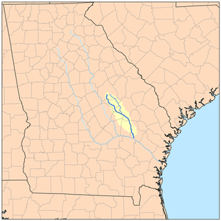
Beards Creek is an unincorporated community in Long County, in the U.S. state of Georgia.
Alex Creek is a stream in the U.S. state of Georgia. It is a tributary to the Altamaha River.
Doctors Creek is a stream in the U.S. state of Georgia. It is a tributary to the Altamaha River.
Fivemile Creek is a stream in the U.S. state of Georgia. It is a tributary to the Altamaha River.
Mushmelon Creek is a stream in Tattnall County in the U.S. state of Georgia. It is a tributary to the Altamaha River.
References
- ↑ U.S. Geological Survey Geographic Names Information System: Beards Creek (Altamaha River tributary)
- ↑ Krakow, Kenneth K. (1975). Georgia Place-Names: Their History and Origins (PDF). Macon, GA: Winship Press. p. 15. ISBN 0-915430-00-2.
Coordinates: 31°47′22″N81°57′50″W / 31.78944°N 81.96389°W