
Garrett County is the westernmost county of the U.S. state of Maryland. As of the 2010 census, the population was 30,097, making it the third-least populous county in Maryland. Its county seat is Oakland. The county was named for John Work Garrett (1820–1884), president of the Baltimore and Ohio Railroad. Created from Allegany County, Maryland in 1872, it was the last Maryland county to be formed.
Interstate 79 (I-79) is an Interstate Highway in the eastern United States, designated from I-77 in Charleston, West Virginia to Pennsylvania Route 5 and PA 290 in Erie, Pennsylvania. It is a primary thoroughfare through western Pennsylvania and West Virginia, and makes up part of an important corridor to Buffalo, New York, and the border with Canada. Major metropolitan areas connected by I-79 include Charleston and Morgantown in West Virginia, and Pittsburgh, and Erie in Pennsylvania. In West Virginia, I-79 is known as the Jennings Randolph Expressway, named for Jennings Randolph. In the three most northern counties it is signed as part of the High Tech Corridor. For most of its Pennsylvania stretch, it is known as the Raymond P. Shafer Highway, named for Raymond P. Shafer.

Jefferson Hills is a borough in Allegheny County, Pennsylvania, United States. It includes the community of Large. In the 2010 census the population was 10,619. Jefferson Hills was created as Jefferson Township, incorporating on January 22, 1828, and named after Thomas Jefferson. The borough is a part of West Jefferson Hills School District. Before 1998, the borough was known as Jefferson.

Penn Hills is a township with home rule status in Allegheny County, Pennsylvania, United States. The population as of the 2010 census was 42,329. Penn Hills is the second-largest municipality in Allegheny County, after the city of Pittsburgh.
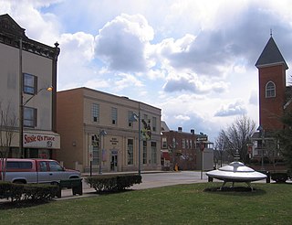
Mars is a borough in Butler County, Pennsylvania, United States. The population was 1,699 at the 2010 census.

Marion Center is a borough in Indiana County, Pennsylvania, United States. The population was 451 at the 2010 census.
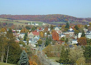
Ligonier is a borough in Westmoreland County, Pennsylvania, United States. The population was 1,573 at the 2010 census. Ligonier was settled in the 1760s. The borough is well known for nearby Idlewild Park, one of the oldest amusement parks in the country; and nearby Seven Springs Mountain Resort. Another tourist attraction is Fort Ligonier Days, a parade and craft market that takes place every fall over the course of three days, and the Ligonier Country Market in the summer months. Ligonier is part of the Pittsburgh Metropolitan Statistical Area.

The Allegheny County Belt System color codes miscellaneous county roads to form a unique system of routes in Allegheny County, Pennsylvania, and around the city of Pittsburgh.
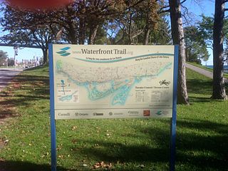
Stretching over 3600 km from Prince Township, west of Sault Ste. Marie, to the Quebec border, the Great Lakes Waterfront Trail is a signed route of interconnecting roads and off-road trails joining over 150 communities and First Nations along the Canadian shores of the Great Lakes and St. Lawrence River. A celebration of nature and culture, the Great Lakes Waterfront Trail is part of a strategy to protect and connect people to the largest group of freshwater lakes on earth. It is a legacy project of the Waterfront Regeneration Trust, a charity, and its community partners. Through Toronto, the trail is called the Martin Goodman Trail. The Waterfront Trail is also used by commuters in parts of Southern Ontario.

The Jones and Laughlin Steel Company began as the American Iron Company, founded in 1852 by Bernard Lauth and B. F. Jones, a few miles south of Pittsburgh along the Monongahela River. Lauth's interest was bought in 1854 by James Laughlin. The first firm to bear the name of Jones and Laughlin was organized in 1861 and headquartered at Third & Ross in downtown Pittsburgh.

The South Side Flats is a neighborhood in Pittsburgh, Pennsylvania's South Side area. It is located just south of the Monongahela River. The neighborhood has one of the City of Pittsburgh's largest concentrations of 19th-century homes, which has prompted outsiders to call the neighborhood the City's Georgetown. It includes many bars and restaurants as well as residences. The main throughway in the South Side Flats is East Carson Street. The street is home to a significant portion of Pittsburgh's nightlife.

Hays is a neighborhood in the 31st Ward of the east side of Pittsburgh, Pennsylvania. It is represented on the Pittsburgh City Council by the representative of District 5. It occupies ZIP codes 15227, 15207, and 15236. It is named after James H. Hays, who opened a coal-mining operation called Hays and Haberman Mines in 1828.
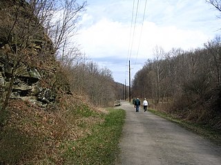
The Montour Trail is a multi-use recreational rail trail near Pittsburgh, Pennsylvania. It was formerly the Montour Railroad.

Pittsburgh, surrounded by rivers and hills, has a unique transportation infrastructure that includes roads, tunnels, bridges, railroads, inclines, bike paths, and stairways.
Pennsylvania Route 50 is a 32.7-mile-long (52.6 km) state highway located in western Pennsylvania. The western terminus of the route is at PA 844 in the Independence Township community of Independence less than a mile from the West Virginia state line. The eastern terminus is at PA 60 in Crafton Heights. Part of its routing used to be PA 28, which now terminates in the Pittsburgh neighborhood of Crafton Heights.

Brownsville Road is a road between Pittsburgh, at Eighteenth Street and South Avenue in Allegheny County, Pennsylvania eastwards through Mount Oliver and generally highlands situated along or near the hilltops often overlooking the Monongahela River. It has had several names over its history, and was also known at the Red Stone Road and the period it was a Plank Road managed as a toll road, the Brownsville Plank Road, or the Brownsville Turnpike, or locally, as the area grew into a city, Southern Avenue.
Fort Robert Smalls was a Civil War redoubt built by free Blacks for the defense of Pittsburgh in 1863.
Becks Run is a tributary of the Monongahela River. As an urban stream, it is heavily polluted, receiving combined sewer outflow from Carrick (Pittsburgh) and Mount Oliver, Pennsylvania. There is a waterfall on a tributary, just downstream from a slate dump, near the intersection of Wagner Avenue and Mountain Avenue. There were coal mines along the stream, including Becks Run #2, owned by the estate of James H. Hays, served by an incline and the H.B. Hays and Brothers Coal Railroad. Other mines at various times were operated by the Birmingham Coal Company, H.G. Burghman, Jones & Laughlin, and the Monongahela River Consolidated Coal and Coke Company.
The Keeling Coal Company (1861-1878) was a 19th-century coal mining company in Allegheny County, Pennsylvania. Its mines were located in the Pittsburgh Coalfield of western Pennsylvania.
Blainsburg is an unincorporated outlier community of West Brownsville, PA; by tradition a hamlet sized neighborhood with more actual housing acreage than West Brownsville proper in Washington County, Pennsylvania, United States. Named after a U.S. Senator, James G. Blaine. Blainsburg is part of the California Area School District. West Brownsville residence students attend Brownsville Area School District in Fayette County, Pennsylvania. The bedroom community is situated on the bluff above and slightly North-northwest of West Brownsville on the river bottom below. Blainsburg is located alongside but above the climb PA Route 88 makes from the W. Brownsville river flats which bends right entering a shelf where it connects with the northwest streets of Blainsburg before taking a second ascent towards California. The parent and child communities are on the inside curve of a great meander in the Monongahela River in Southwestern Pennsylvania creating a degraded cut bank turned ramp and terrace on the opposite shore where Brownsville is situated. Blainsburg is often misspelled with an "E" in it, to match the spelling of its namesake, James G. Blaine. Blainsburg as of official records was founded in 1906 and is still spelled without the "E".
