
The Appalachian Mountains, often called the Appalachians, are a mountain range in eastern to northeastern North America. The term "Appalachian" refers to several different regions associated with the mountain range, and its surrounding terrain. The general definition used is one followed by the United States Geological Survey and the Geological Survey of Canada to describe the respective countries' physiographic regions. The U.S. uses the term Appalachian Highlands and Canada uses the term Appalachian Uplands; the Appalachian Mountains are not synonymous with the Appalachian Plateau, which is one of the provinces of the Appalachian Highlands.

The Mohawk River is a 149-mile-long (240 km) river in the U.S. state of New York. It is the largest tributary of the Hudson River. The Mohawk flows into the Hudson in Cohoes, New York, a few miles north of the state capital of Albany. The river is named for the Mohawk Nation of the Iroquois Confederacy. A major waterway, in the early 19th century, the river's east-west valley provided the setting and water for development of the Erie Canal, as a key to developing New York. The largest tributary, the Schoharie Creek, accounts for over one quarter (26.83%) of the Mohawk River's watershed. Another main tributary is the West Canada Creek, which makes up for 16.33% of the Mohawk's watershed.
The Catskill High Peaks are all of the mountains in New York's Catskill Mountains above 3,500 ft (1,067 m) in elevation whose summits are separated either by one-half mile (0.8 km) or a vertical drop of at least 250 ft (76.2 m) between it and the next nearest separate summit. By usual standards, these mountains are rather low and rounded, and mostly covered by vegetation.

Schoharie Creek is a river in New York that flows north 93 miles (150 km) from the foot of Indian Head Mountain in the Catskills through the Schoharie Valley to the Mohawk River. It is twice impounded north of Prattsville to create New York City's Schoharie Reservoir and the Blenheim-Gilboa Power Project.

The Sacandaga River is a 64-mile-long (103 km) river in the northern part of New York in the United States. Its name comes from the Native American Sa-chen-da'-ga, meaning "overflowed lands".

The Salt River is a 150-mile-long (240 km) river in the U.S. state of Kentucky that drains 2,920 square miles (7,600 km2). It begins near Parksville, Kentucky, rising from the north slope of Persimmon Knob south of KY 300 between Alum Springs and Wilsonville, and ends at the Ohio River near West Point. Taylorsville Lake is formed from the Salt River, and Guist Creek Lake is also in its drainage basin.

Rusk Mountain is a peak located in the towns of Jewett and Lexington in Greene County, New York, United States. At 3,680 feet (1,120 m) in elevation, it is the 20th-highest peak in the Catskill Mountains and considered a member of the Catskill High Peaks. While there is no maintained trail, a bushwhack to the summit is considered relatively easy, and required for membership in the Catskill Mountain 3500 Club.

Prairie Township is one of thirteen townships in Henry County, Indiana, United States. As of the 2010 census, its population was 5,517 and it contained 1,346 housing units.

Vly Mountain is a mountain located in the town of Halcott, New York, United States in Greene County. The mountain is part of the Catskill Mountains. Vly Mountain is flanked to the northwest by Bearpen Mountain, to the east by Vinegar Hill, to the northeast by Kipp Hill, and to the southeast by Beech Ridge.

Balsam Lake Mountain is one of the Catskill Mountains, located in the Town of Hardenburgh, New York, United States. It is the westernmost of the range's 35 High Peaks. Its exact height has not been determined, but the highest contour line on topographic maps, 3,720 feet (1,130 m), is usually given as its elevation.
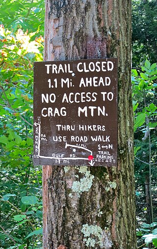
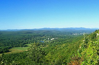
Crag Mountain, 1,503 feet (458 m), of the Bald Hills region of east Franklin County, Massachusetts is the southern and most apparent summit of Brush Mountain, 1,507 feet (459 m). Narrow and precipitous, the mountain offers expansive views from its open, knife-edge summit. Crag Mountain is composed of quartzite, a weather-resistant metamorphic rock. The 114 mile (183 km) Metacomet-Monadnock Trail traverses its summit ridge. Crag Mountain is located within the town of Northfield, Massachusetts.

Graham Mountain is the seventh highest of the Catskill High Peaks and the highest privately owned mountain in the range. It is located in the town of Hardenburgh, New York, United States.

Brace Mountain is the peak of a ridge in the southern Taconic Mountains, near the tripoint of the U.S. states of New York, Connecticut and Massachusetts. Its 2,311-foot (704 m) main summit is located in New York; it is the highest point in that state's Dutchess County.
The Verkeerder Kill, sometimes Verkeerderkill and locally shortened to Kaidy Kill is an 8-mile-long (13 km) stream in Ulster County, New York, United States. It rises on the Shawangunk Ridge, in the town of Wawarsing, and flows southwards through the town of Shawangunk, toward the Shawangunk Kill, itself a major tributary of the Wallkill River. Ultimately it is a part of the Hudson River's watershed.
East Kill, a 16-mile-long (26 km) tributary of Schoharie Creek, flows across the town of Jewett, New York, United States, from its source on Stoppel Point. Ultimately its waters reach the Hudson River via the Mohawk. Since it drains into the Schoharie upstream of Schoharie Reservoir, it is part of the New York City water supply system. East Kill drains the southern slopes of the Blackhead Mountains, which include Thomas Cole Mountain, Black Dome, and Blackhead Mountain, the fourth-, third-, and fifth-highest peaks in the Catskills, respectively.

The West Kill, an 11-mile-long (18 km) tributary of Schoharie Creek, flows through the town of Lexington, New York, United States, from its source on Hunter Mountain, the second-highest peak of the Catskill Mountains. Ultimately its waters reach the Hudson River via the Mohawk. Since it drains into the Schoharie upstream of Schoharie Reservoir, it is part of the New York City water supply system. It lends its name to both a mountain to its south and a small town midway along its length.
Beech Ridge is a ridge located in Greene County, New York southwest of Lexington, New York. Located to the northwest is Vly Mountain and to the north of Vinegar Hill. Beech Ridge drains north into Beech Ridge Brook, east into West Kill and south into Condon Hollow.

Carr Mountain is a 3,453-foot-high (1,052 m) mountain in the southwestern part of the White Mountains in the towns of Wentworth and Warren, New Hampshire, United States. It is the highest of a set of mountains ringed by Interstate 93 to the east, New Hampshire Route 25 to the south and west, New Hampshire Route 118 to the northwest, and New Hampshire Route 112 to the north, and that are in the White Mountain National Forest.
