
Port of Spain, officially the City of Port of Spain, is the capital city of Trinidad and Tobago and the country's second-largest city after San Fernando and the third largest municipality after Chaguanas and San Fernando. The city has a municipal population of 37,074, an urban population of 81,142 and a transient daily population of 250,000. It is located on the Gulf of Paria, on the northwest coast of the island of Trinidad and is part of a larger conurbation stretching from Chaguaramas in the west to Arima in the east with an estimated population of 600,000.

Conway is a census-designated place and an unincorporated area in Orange County, Florida, United States. The population was 13,467 at the 2010 census. It is part of the Orlando–Kissimmee–Sanford, Florida Metropolitan Statistical Area.

Pleasant Lake is a neighborhood of the city of Rockville in Stearns County, Minnesota, United States. The population was 504 at the 2000 census. Pleasant Lake was settled about 1890 and incorporated on July 11, 1938. On 1 June 2002, the city of Pleasant Lake and Rockville Township were merged into the city of Rockville. At the center of the community, lies the 400 Supper Club which lines the lakefront of Pleasant Lake. Most notable for its venue in weddings, conferences, and banquets, the 400 Supper Club also hosts the annual Polar bear plunge to raise money for the Special Olympics.

Lionville is a census-designated place (CDP) in Uwchlan Township, Chester County, Pennsylvania, United States. The population was 6,189 at the 2010 census. Prior to 2010 the CDP was recorded as Lionville-Marchwood. "Marchwood", however, refers only to the housing development begun in the early 1960s that is located south of the 100-113 intersection.

Laceyville is a borough in Wyoming County, Pennsylvania, United States. The population was 379 at the 2010 census.

White Stone is a town in Lancaster County, Virginia, United States. The population was 352 at the 2010 census. The name "White Stone" refers to the accumulations of white stones in the area's waterways. The stones were dumped there in the colonial era by British ships that dumped their stone ballast to make room for cargo like tobacco to carry back to England.
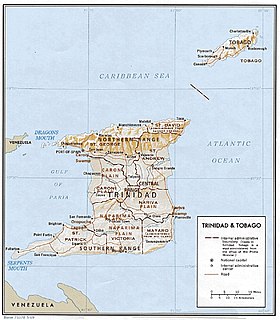
The Northern Range is the range of tall hills across north Trinidad, the major island in the Republic of Trinidad and Tobago. The hills range from the Chaguaramas peninsula on the west coast to Toco in the east. The Northern Range covers approximately twenty-five percent of the land area of Trinidad.

Mayaro is the name of a county on southeastern Trinidad island, in Trinidad and Tobago.
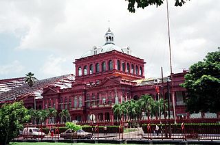
The Parliament of Trinidad and Tobago is the legislative branch of the Government of Trinidad and Tobago. The Parliament is bicameral. It consists of the elected House of Representatives, which has 41 members elected for a five-year term in single-seat constituencies, and the Senate which has 31 members appointed by the President: 16 Government Senators appointed on the advice of the Prime Minister, 6 Opposition Senators appointed on the advice of the Leader of the Opposition and 9 Independent Senators appointed by the President to represent other sectors of civil society.
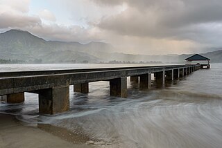
Hanalei Bay is the largest bay on the north shore of Kauaʻi island in Hawaii. The town of Hanalei is at the midpoint of the bay.
The Lady Young Road is a major roadway in Trinidad and Tobago linking the Eastern Main Road in Barataria to the Queen's Park Savannah in Port of Spain. It is also an important connector between the Churchill-Roosevelt Highway and uptown Port of Spain.

Emmet Township is located in McDonough County, Illinois. As of the 2010 census, its population was 1,288 and it contained 584 housing units.

The Fort Yuma Indian Reservation is a part of the traditional lands of the Quechan people. Established in 1884 from the former Fort Yuma, the reservation, at 32°47′04″N114°38′43″W, has a land area of 178.197 km2 (68.802 sq mi) in southeastern Imperial County, California, and western Yuma County, Arizona, near the city of Yuma, Arizona. Both the county and city are named for the tribe. As of the 2010 Census the population was 2,189. In 1910, the community of Bard, California was created after the eastern part of the reservation was declared surplus under the Dawes Act.
Sverdrup Pass is a mountain pass in central Ellesmere Island, Nunavut, Canada.

Gasparillo is a small island in the Republic of Trinidad and Tobago. It is one of the Bocas Islands, which lie in the Bocas del Dragón between the main island of Trinidad and Venezuela. The island is currently uninhabited.
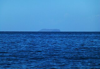
Patos Island is a small uninhabited island in the northwestern Gulf of Paria. The island is a part of the Dependencias Federales of Venezuela.

Clinton is a census-designated place (CDP) and the primary village in the town of Clinton in Kennebec County, Maine, United States. The population was 1,419 at the 2010 census, out of 3,486 in the entire town of Clinton.
Trombley is an unincorporated community in Wood County, in the U.S. state of Ohio.

Drysdale is a census-designated place (CDP) in Yuma County, Arizona, United States. The population was 272 at the 2010 census.
