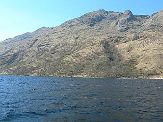
Beinn a' Chapuill

Last updated
Beinn a' Chapuill
Beach, Bernera - geograph.org.uk - 913668.jpg
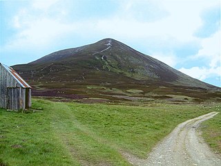
Beinn a' Chapuill from near Glenelg
Highest point
Elevation 759 m (2,490 ft) [1]
Prominence 258 m (846 ft)
Listing Graham, Marilyn
Geography
Location Ross and Cromarty, Scotland
Parent range Northwest Highlands
OS grid NG835141
Topo map OS Landranger 33

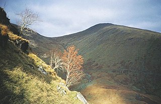
Beinn a' Chapuill (759 m) is a mountain in the Northwest Highlands of Scotland. It is located in Ross and Cromarty, close to the community of Glenelg.

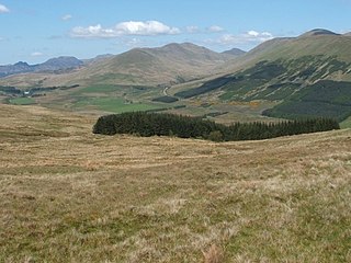
The Northwest Highlands are located in the northern third of Scotland that is separated from the Grampian Mountains by the Great Glen. The region comprises Wester Ross, Assynt, Sutherland and part of Caithness. The Caledonian Canal, which extends from Loch Linnhe in the south-west, via Loch Ness to the Moray Firth in the north-east splits this area from the rest of the country. The city of Inverness and the town of Fort William serve as gateways to the region from the south.

Ross and Cromarty area in the Highlands and Islands of Scotland

Ross and Cromarty is a variously defined area in the Highlands and Islands of Scotland. There is a registration county and a lieutenancy area in current use, the latter of which is 8,019 square kilometres in extent. Historically there has also been a constituency of the Parliament of the United Kingdom, a local government county, a district of the Highland local government region and a management area of the Highland Council. The local government county is now divided between two local government areas: the Highland area and Na h-Eileanan Siar.

Glenelg, Highland human settlement

Glenelg is a scattered community area and civil parish in the Lochalsh area of Highland in western Scotland. Despite the local government reorganisation the area is considered by many still to be in Inverness-shire, the boundary with Ross-shire being at the top of Mam Ratagan the single track road entry into Glenelg.

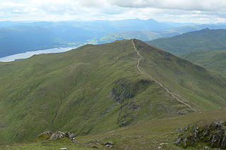
A rugged peak, its finest feature is its long east ridge. The famous brochs of Dun Telve and Dun Troddan lie in close proximity. [2]

Broch type of Iron Age drystone hollow-walled structure

A broch is an Iron Age drystone hollow-walled structure found in Scotland. Brochs belong to the classification "complex atlantic roundhouse" devised by Scottish archaeologists in the 1980s. Their origin is a matter of some controversy.

Dun Telve An iron-age broch located about 4 kilometres southeast of the village of Glenelg, in Scotland, UK.

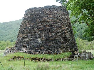
Dun Telve is an iron-age broch located about 4 kilometres (2.5 mi) southeast of the village of Glenelg, Highland, in Scotland. It is one of the best preserved brochs in Scotland.

Dun Troddan An iron-age broch located about 5 kilometres southeast of the village of Glenelg, in Scotland, UK.

Dun Troddan is an iron-age broch located about 5 kilometres (3.1 mi) southeast of the village of Glenelg, Highland, in Scotland. It is one of the best-preserved brochs in Scotland.

Related Research Articles

Beinn Ghlas 1103m high mountain in Scotland

Beinn Ghlas is a mountain in the Southern Highlands of Scotland. It lies on the north shore of Loch Tay and is part of the Ben Lawers Range. It lies on the popular path to Ben Lawers from the National Trust for Scotland car park, with the result that many walkers traverse the summit of Beinn Ghlas without realising it. The popularity of the path meant that it suffered from severe erosion, but it has been reconstructed in recent years.

Beinn Odhar Bheag

Beinn Odhar Bheag is a mountain in the Northwest Highlands, Scotland, south of the village of Glenfinnan in Moidart, Lochaber.

Beinn a Chlachair Mountain in Scotland

Beinn a' Chlachair is a mountain in the Grampian Mountains of Scotland. It lies north of Loch Laggan, near the remote hamlet of Kinloch Laggan.

Beinn Dearg Bheag Mountain in Scotland

Beinn Dearg Bheag is a mountain in the Northwest Highlands, Scotland. It is located in the wild Dundonnell and Fisherfield Forest area of Wester Ross, a long way from any road or settlement.

Beinn na Lap

Beinn na Lap is a mountain in the Grampian Mountains of Scotland. It lies at the northern end of Rannoch Moor, near to Corrour railway station.

Beinn Dearg (Blair Atholl)

Beinn Dearg is a mountain in the Grampian Mountains of Scotland. It lies north of the village of Blair Atholl in Perthshire.

Beinn nan Aighenan

Beinn nan Aighenan is a mountain in the Grampian Mountains of Scotland. It lies in Argyll and Bute, north of the village of Taynuilt.

Beinn Eunaich Mountain in Scotland

Beinn Eunaich is a mountain in the Grampian Mountains of Scotland, located north of the village of Dalmally in Argyll and Bute.

Beinn Iutharn Mhòr

Beinn Iutharn Mhor is a mountain in the Grampian Mountains of Scotland. It lies north of Glen Shee on the Aberdeenshire and Perthshire border.

Beinn a Chochuill

Beinn a' Chochuill is a mountain in the Grampian Mountains of Scotland, located east of Loch Etive in Argyll and Bute.

Beinn Bheoil

Beinn Bheoil is a mountain in the Grampian Mountains of Scotland, located on the western shore of Loch Ericht in Highland.

Beinn a Bhuiridh

Beinn a' Bhuidhe is a mountain in the Grampian Mountains of Scotland, west of the village of Dalmally in Argyll and Bute.

Beinn Ghobhlach

Beinn Ghiobhlach is a mountain in the Northwest Highlands of Scotland. It lies on the Scoraig peninsula between the two Loch Brooms in Wester Ross.

Beinn na h-Uamha

Beinn na h-Uamha is a mountain in the Northwest Highlands of Scotland. It lies in the Ardgour area of Lochaber, west of the village of Corran.

Beinn a Mhanaich

Beinn a' Mhanaich is a hill in the southern Grampian Mountains of Scotland. It is located in Argyll and Bute, in the southern Luss Hills north of the town of Helensburgh.

Beinn a Chearcaill

Beinn a' Chearcaill is a mountain in the Torridon Hills of northwest Scotland. It lies south of Loch Maree in Wester Ross.

Beinn na h-Eaglaise (Graham)

Beinn na h-Eaglaise is a mountain in the Northwest Highlands of Scotland. It lies in Wester Ross, south of the village of Torridon.

Meall Mheinnidh

Meall Mheinnidh is a mountain in the Northwest Highlands of Scotland. It lies in the Wester Ross region, north of Loch Maree.

Beinn nan Eun

Beinn nan Eun is a mountain in the Northwest Highlands of Scotland. It is located in Easter Ross, several miles northwest of Dingwall.

Càrn Liath (Munro)

Carn Liath is a mountain in the Grampian Mountains of Scotland. It lies east of Blair Atholl in Perthshire, Scotland.

References

  1. "Meall Mor". hill-bagging.co.uk. Retrieved 6 June 2019.
  2. "walkhighlands Beinn a' Chapuill". walkhighlands.co.uk. Retrieved 6 June 2019.