Related Research Articles

Rio de Janeiro, or simply Rio, is the capital of the state of the same name, Brazil's third most populous state, and the second most populous city in Brazil, after São Paulo. Listed by the GaWC as a beta global city, Rio de Janeiro is the sixth most populous city in the Americas. Part of the city has been designated as a World Heritage Site, named "Rio de Janeiro: Carioca Landscapes between the Mountain and the Sea", on 1 July 2012 as a Cultural Landscape.

Rio de Janeiro is one of the 27 federative units of Brazil. It has the second largest economy of Brazil, with the largest being that of the state of São Paulo. The state, which has 8.2% of the Brazilian population, is responsible for 9.2% of the Brazilian GDP.
Volta Redonda is the name of a municipality in the Rio de Janeiro state of Brazil with an area of 182.81 km2, located from 350m to 707m above the sea level and with a population of 273,988 inhabitants. The area around the city has nearly 700,000 km2. Its name is due to the round shape of a curve in the Paraíba do Sul river around which the city was built.
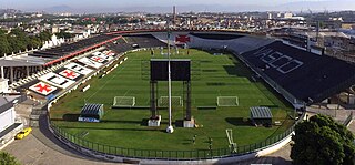
Estádio Vasco da Gama, also known as Estádio São Januário, owing to its location on a street of the same name, is the home ground of Club de Regatas Vasco da Gama. Its facade is listed by the National Historical and Artistic Heritage.

Brazil is geopolitically divided into five regions, by the Brazilian Institute of Geography and Statistics, which are formed by the federative units of Brazil. Although officially recognized, the division is merely academic, considering geographic, social and economic factors, among others, and has no political effects other than orientating Federal-level government programs. Under the state level, they are further divided into intermediate regions and even further into immediate regions.
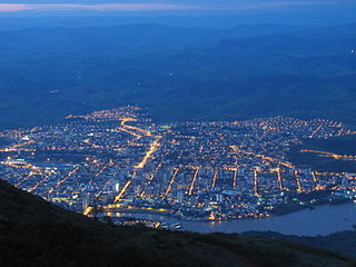
Governador Valadares is a Brazilian municipality in the countryside of Minas Gerais. In 2020, its population was 281,046 inhabitants, thus being the ninth most populated city in the state. It is an economical axis of the middle valley of the Doce River, having a significant influence on the east and northeast portion of Minas Gerais and local authorities of the state of Espírito Santo. Governador Valadares sits on the bank of the Doce River, 324 km from Belo Horizonte, the state's capital. Governador Valadares has an area of about 2 342 km2, being only 58 km2 of urban area.

Nova Iguaçu is a municipality in Rio de Janeiro state in Brazil.

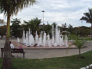
Campos dos Goytacazes is a municipality located in the northern region of Rio de Janeiro State, Brazil, with a population of 471,737 inhabitants.

Espera Feliz is a municipality in southeastern Minas Gerais state, Brazil. The altitude is 2,430 m above sea level. Located at 20°39′00″S41°54′25″W, its neighboring cities are Caiana to the south, Dores do Rio Preto to the east, Divino to the west, Alto Caparaó and Caparaó to the north and Carangola to the southwest.

The Baixada Fluminense is a region in the state of Rio de Janeiro, in southeastern Brazil. It is located on Guanabara Bay, between Rio de Janeiro to the south and the Serra dos Órgãos range of hills to the north.

Bom Jesus do Itabapoana is a municipality in the Brazilian state of Rio de Janeiro. It had a population of 37,203 as of 2020, and has an area of 598,8 km2. It was founded in 1939, after being separated from the municipality of Itaperuna.

Pedra Azul is a Brazilian municipality in the state of Minas Gerais, located in the northeast of the state, in the Jequitinhonha River valley region. The population in 2020 was 24,329 in a total area of 1,619 km2.

Campinas do Sul is a municipality in the state of Rio Grande do Sul, Brazil. As of 2020, the estimated population was 5,438.
The Federal Rural University of Rio de Janeiro is a public university located in Seropédica in the State of Rio de Janeiro, Brazil. It possesses the largest campus among Latin American universities and is known for being the first university to offer agriculture related courses in Brazil.
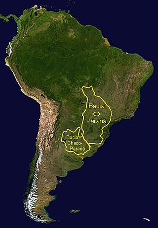
The Paraná Basin is a large cratonic sedimentary basin situated in the central-eastern part of South America. About 75% of its areal distribution occurs in Brazil, from Mato Grosso to Rio Grande do Sul states. The remainder area is distributed in eastern Paraguay, northeastern Argentina and northern Uruguay. The shape of the depression is roughly elliptical and covers an area of about 1,500,000 km2 (580,000 sq mi).

The Carangola River is a river of Minas Gerais and Rio de Janeiro states in southeastern Brazil.
The Dois Rios River is a river of Rio de Janeiro state in southeastern Brazil.
The Imboacica River is a river of Rio de Janeiro state in southeastern Brazil.
The Macabu River is a river of Rio de Janeiro state in southeastern Brazil.
The Macabuzinho River is a river of Rio de Janeiro state in southeastern Brazil.
References
Coordinates: 21°43′S41°37′W / 21.717°S 41.617°W