
Stafford County is a county located in the Commonwealth of Virginia. It is approximately 40 miles (64 km) south of D.C. It is part of the Northern Virginia region, and the D.C area. It is one of the fastest growing, and highest income counties in America. As of the 2020 census, the population sits at 156,927. Its county seat is Stafford.

Falmouth is a census-designated place (CDP) in Stafford County, Virginia, United States. Situated on the north bank of the Rappahannock River at the falls, the community is north of and opposite the city of Fredericksburg. Recognized by the U.S. Census Bureau as a census-designated place (CDP), Falmouth's population was 4,956 as of the 2020 census.
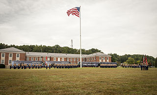
Marine Corps Base Quantico is a United States Marine Corps installation located near Triangle, Virginia, covering nearly 55,148 acres of southern Prince William County, Virginia, northern Stafford County, and southeastern Fauquier County. Used primarily for training purposes, MCB Quantico is known as the "Crossroads of the Marine Corps".

The Richmond, Fredericksburg, and Potomac Railroad was a railroad connecting Richmond, Virginia, to Washington, D.C. The track is now the RF&P Subdivision of the CSX Transportation system; the original corporation is no longer a railroad company.

The Battle of Hanover Court House, also known as the Battle of Slash Church, took place on May 27, 1862, in Hanover County, Virginia, as part of the Peninsula Campaign of the American Civil War.
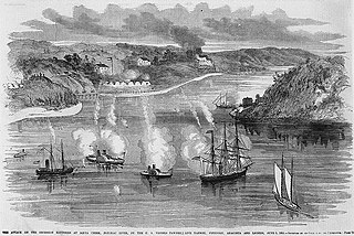
The Battle of Aquia Creek was an exchange of cannon fire between Union Navy gunboats and Confederate shore batteries on the Potomac River at its confluence with Aquia Creek in Stafford County, Virginia. The battle took place from May 29, 1861 to June 1, 1861 during the early days of the American Civil War. The Confederates set up several shore batteries to block Union military and commercial vessels from moving in the Chesapeake Bay and along the lower Potomac River as well as for defensive purposes. The battery at Aquia also was intended to protect the railroad terminal at that location. The Union forces sought to destroy or remove these batteries as part of the effort to blockade Confederate States coastal and Chesapeake Bay ports. The battle was tactically inconclusive. Each side inflicted little damage and no serious casualties on the other. The Union vessels were unable to dislodge the Confederates from their positions or to inflict serious casualties on their garrisons or serious damage to their batteries. The Confederates manning the batteries were unable to inflict serious casualties on the Union sailors or cause serious damage to the Union vessels. Soon after the battle, on Sunday, July 7, 1861, the Confederates first used naval mines, unsuccessfully, off the Aquia Landing batteries. The Confederates ultimately abandoned the batteries on March 9, 1862 as they moved forces to meet the threat created by the Union Army's Peninsula Campaign. The U. S. National Park Service includes this engagement in its list of 384 principal battles of the American Civil War.

The Battle of Cockpit Point, the Battle of Freestone Point, or the Battle of Shipping Point, took place on January 3, 1862, in Prince William County, Virginia, as part of the blockade of the Potomac River during the American Civil War.
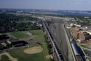
Potomac Yard is a neighborhood in Northern Virginia that straddles southeastern Arlington County and northeastern Alexandria, Virginia, located principally in the area between U.S. Route 1 and the Washington Metro Blue Line /Yellow Line tracks, or the George Washington Memorial Parkway, depending on the definition used. The area was home to what was once one of the busiest rail yards on the Eastern Seaboard of the United States. The "Potomac Yard" name is also used to refer to several developments in the area, especially the Potomac Yard Center power center and a Washington Metro station.

Aquia Creek is a 27.6-mile-long (44.4 km) tributary of the tidal segment of the Potomac River and is located in Northern Virginia. The creek's headwaters lie in southeastern Fauquier County, and it empties into the Potomac at Brent Point in Stafford County, 45 miles (72 km) south of Washington, D.C.

Four Mile Run is a 9.4-mile-long (15.1 km) stream in Northern Virginia that starts near Interstate 66, at Gordon Avenue in Fairfax County and proceeds southeast through Falls Church to Arlington County in the U.S. state of Virginia. Most of the stretch is parkland and is paralleled by two paved non-motorized transport and recreational trails, the Washington and Old Dominion Railroad Trail and the Four Mile Run Trail.
USS Anacostia was a steamer, constructed as a tugboat, that was first chartered by the United States Navy for service during the Paraguay crisis of the 1850s and then commissioned as a U.S. Navy ship. She later served prominently in the Union Navy during the American Civil War.

Crow's Nest Natural Area Preserve is a large wilderness area located on the southern border of Stafford County, Virginia, United States, between Potomac Creek and Accokeek Creek. The greater portion of the Crow's Nest Peninsula is approximately 3,800 acres (15 km2) and lies within the coastal plain of Virginia. About 3,115 acres (12.61 km2) of the peninsula is protected as part of the Virginia Natural Area Preserve System. Funding for the original two tracts came from a number of sources including DCR, Stafford County, Virginia Department of environmental Quality and a number other sources.
Brooke is an unincorporated community in Stafford County, Virginia, United States.

Aquia Creek sandstone is a brown to light-gray freestone used extensively in building construction in Washington, D.C. in the late 18th and early 19th centuries. Quarried at Aquia Creek in Stafford County, Virginia, the stone was valuable for its ease of shaping and the quarry's proximity to the tidewater portion of the Potomac River, 45 miles (72 km) south of Washington.

The Potomac Creek Bridge was first built in 1842 by the Richmond, Fredericksburg and Potomac Railroad across the Potomac Creek in Stafford County, Virginia, United States.
Aquia is an unincorporated community in Stafford County, in the U.S. state of Virginia. It is named for Aquia Creek, which leads to the Potomac River. Nearby historic locations include Aquia Church and the remains of Aquia quarry. Cliffs of the local Aquia Creek sandstone had been visible from the Potomac River near its confluence with Aquia Creek during colonial times. It was quarried to construct many buildings nearby, as well as in Washington, D.C., including the White House, National Capitol Columns and Washington Monument. It was a stop on the Richmond, Fredericksburg and Potomac Railroad which was replaced by, CSXT.
Tacketts Mill is an unincorporated community in Stafford County, in the U.S. state of Virginia.
The Potomac Steamboat Company served as the direct water link between the Richmond, Fredericksburg and Potomac Railroad and the Baltimore and Ohio Railroad from 1845 and 1872. Its predecessor was the Washington and Fredericksburg Steamboat Company, renamed after the RF&P acquired majority control. After May 1, 1872, the connection was made at Quantico Creek.

The 56th Pennsylvania Volunteer Infantry was an infantry regiment that served in the Union Army during the American Civil War. The unit has the distinction of being the first Union Army infantry regiment to open fire at the Battle of Gettysburg.

Widewater State Park is a state park in Virginia, located in Stafford County. Land for the park was purchased in 2006 from Dominion Resources, but the Great Recession prevented development of the property. Ground was finally broken for the new park in 2018 after money was appropriated by the Virginia General Assembly with a bond issue in that year. Current facilities include a visitor center and staff building along Aquia Creek and a soft boat launch and picnic shelter along the Potomac River. A formal opening date in fall 2018 was set. The park officially opened in 2019.
