
Toijala is a former town and municipality of Finland, located some 40 kilometres south of Tampere. On 1 January 2007, it was consolidated with Viiala to form the town of Akaa.
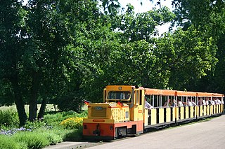
The Killesberg Railway is a miniature railway in the Killesberg Park in Stuttgart, Germany.
Pyramid Creek Falls Provincial Park is a provincial park in British Columbia, Canada, located on the east side of the North Thompson River between the towns of Blue River (S) and Valemount (N).
Belinga is a location in Gabon with as yet unexploited iron ore deposits. These ore deposits extend into neighbouring Cameroon and Congo.
The Squamish Nation, Sḵwx̱wú7mesh Úxwumixw in Sḵwx̱wú7mesh Sníchim, is an Indian Act government originally imposed on the Squamish (Sḵwx̱wú7mesh) by the Federal Government of Canada in the late 19th century. The Squamish are Indigenous to British Columbia, Canada. Their band government comprises 16 elected councillors, serving four-year terms, with an elected band manager. Their main reserves are near the town of Squamish, British Columbia and around the mouths of the Capilano River, Mosquito Creek, and Seymour River on the north shore of Burrard Inlet in North Vancouver, British Columbia.
Chemelil is a town in Kisumu County, Kenya. It is part of Muhoroni District. Chemelil has a railway station along the Nairobi-Kisumu Railway between the stations of Kibigori and Muhoroni. The town is located 40 kilometres east of Kisumu, the county capital. Muhoroni, another town, is located 10 kilometres east of Chemelil.

The Passerelle, also known as the Luxembourg Viaduct, is a viaduct in Luxembourg City, in southern Luxembourg. Nowadays it runs from the south into the city centre, Ville Haute, carrying road traffic across the Pétrusse valley and connecting Avenue de la Gare to Boulevard Franklin Delano Roosevelt. It is 290 m long, with 24 arches, and 45 m above the valley floor.
The Williams Lake Indian Band is a First Nations government of the Secwepemc (Shuswap) Nation, located in the Cariboo region of the Central Interior region of the Canadian province of British Columbia, at the city of Williams Lake. It was created when the government of the then-Colony of British Columbia established an Indian Reserve system in the 1860s. It is a member government of the Northern Shuswap Tribal Council. Its main Indian Reserve is Williams Lake Indian Reserve No. 1, a.k.a. "Sugarcane" or "The Cane" or "SCB".

Mweka is a town in southern-central Democratic Republic of the Congo, situated on the Kasai railway line between Kananga and the Kasai River port of Ilebo.
Funaoka Station is a train station in Nantan, Kyoto Prefecture, Japan.
Kibangou is a small town in the Republic of Congo in the Kouilou Department.

Keetmanshoop railway station is a railway station serving the town of Keetmanshoop in Namibia. It was erected in 1908. when the territory was colonised by Imperial Germany. It is part of the TransNamib Railway, and is located along the Windhoek to Upington line that was inaugurated in 1915 and connects Namibia with South Africa. Keetmanshoop also has a junction to Seeheim and Aus, completed in 1908.
Rongai is a town in Nakuru County, Kenya. It lies 30 km west of Nakuru, along the A104 Road and the railway line between Nakuru and Uganda. It is about 10 kilometres north of Elburgon and 15 kilometres east of Molo. The town lies 1912 m (6272 ft) above sea level and has a population of 20878. Rongai is part of the Rongai Constituency.
Chiromo is a town in southern Malawi by the Shire River.
The Leq' a: mel First Nation, formerly known as the Lakahahmen First Nation, is a First Nations band government whose community and offices are located in the area near Deroche, British Columbia, Canada, about 12 kilometres east of the District of Mission. They are a member government of the Sto:lo Nation tribal council, which is one of two tribal councils of the Sto:lo.
On 22 April 2014, a freight train derailed near the Katongola Bridge in Katanga Province of the Democratic Republic of the Congo. The train was carrying hundreds of illegal passengers at the time of the crash. As a result, 48 people were killed and over 160 injured.
Costa Spur is a prominent spur 4 mi southwest of Quetin Head, Daniell Peninsula, Borchgrevink Coast. The spur descends eastward to the Ross Sea and marks the southern extent of the Mandible Cirque. Named by the Advisory Committee on Antarctic Names in 2005 after Daniel P. Costa, Professor of Ecology and Evolutionary Biology, University of California, Santa Cruz, who studied seals at McMurdo Sound and Livingston Island in several field seasons from 1977; he was chief scientist aboard the Nathaniel B. Palmer for two winter cruises associated with the U.S. Southern Ocean Global Ocean Ecosystem Dynamics (GLOBEC) projects, in 2001 and 2002.
On 21 October 2016, a Camrail inter-city passenger train travelling from Cameroon's capital, Yaoundé, to its largest city, Douala, derailed in Eséka, Centre Region. By 30 October 2016, the official number of casualties had reached 79 dead, with 550 injured. It was the deadliest rail accident on the African continent since the August 2007 Benaleka train accident.


