
Geologically, a fjord or fiord is a long, narrow inlet with steep sides or cliffs, created by a glacier. There are many fjords on the coasts of Alaska, Antarctica, British Columbia, Chile, Greenland, the Faroe Islands, Iceland, Kamchatka, the Kerguelen Islands, New Zealand, Norway, Novaya Zemlya, Labrador, Nunavut, Newfoundland, Quebec, Scotland, South Georgia Island, and Washington state. Norway's coastline is estimated at 29,000 kilometres (18,000 mi) with nearly 1,200 fjords, but only 2,500 kilometres (1,600 mi) when fjords are excluded.

Tarrant County is a county in the U.S. state of Texas. As of 2010, it had a population of 2,054,475. It is Texas' third-most populous county and the 16th-most populous in the United States. Its county seat is Fort Worth.

Benbrook is a city located in the southwestern corner of Tarrant County, Texas, and a suburb of Fort Worth. As of the 2010 United States Census, the population was 21,234, reflecting an increase of 1,026 from the 20,208 counted in the 2000 Census, which had in turn increased by 644 from the 19,564 counted in the 1990 Census.

The Trinity River is a 710-mile-long (1,140 km) river in Texas, and is the longest river with a watershed entirely within the U.S. state of Texas. It rises in extreme northern Texas, a few miles south of the Red River. The headwaters are separated by the high bluffs on the southern side of the Red River.

Benbrook Field is a former World War I military airfield, located 0.5 miles (0.80 km) North of Benbrook, Texas. It operated as a training field for the Air Service, United States Army between 1917 until 1919. It was one of thirty-two Air Service training camps established after the United States entry into World War I in April 1917.
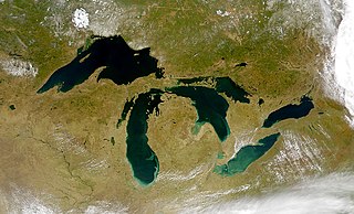
A glacial lake is a lake with origins in a melted glacier. They are formed when a glacier erodes the land, and then melts, filling the hole or space that it has created. Near the end of the last glacial period, roughly 10,000 years ago, glaciers began to retreat. A retreating glacier often left behind large deposits of ice in hollows between drumlins or hills. As the ice age ended, these melted to create lakes. This is apparent in the Lake District in Northwestern England where post-glacial sediments are normally between 4 and 6 metres deep. These lakes are often surrounded by drumlins, along with other evidence of the glacier such as moraines, eskers and erosional features such as striations and chatter marks.

The Swiss Plateau or Central Plateau is one of the three major landscapes in Switzerland, lying between the Jura Mountains and the Swiss Alps. It covers about 30% of the Swiss surface area, and is partly flat but mostly hilly. The average height is between 400 metres (0.25 mi) and 700 metres (0.43 mi) AMSL. It is by far the most densely populated region of Switzerland, the center of economy and important transportation.
Fort Worth Independent School District is a school district based in Fort Worth, Texas, United States. It is the fifth largest school district in Texas.

Western Hills High School (WHHS) is a secondary school located in Benbrook, Texas, United States, serving the city of Benbrook, portions of western Fort Worth, and unincorporated portions of southwestern Tarrant County. The school, which serves grades 9 through 12, is a part of the Fort Worth Independent School District (FWISD).
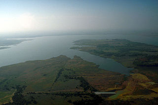
Lake Ray Roberts is a 29,350-acre (119 km2) reservoir located 10 miles (20 km) north of Denton, Texas, between the cities of Pilot Point, Texas and Sanger, Texas. It is filled by a tributary of the Trinity River.

Cedar Creek Reservoir is a reservoir located in Henderson and Kaufman Counties, Texas (USA), 50 miles (80.5 km) southeast of Dallas. It is built on Cedar Creek, which flows into the Trinity River. Floodwaters are discharged through a gated spillway into a discharge channel that connects to the Trinity River.
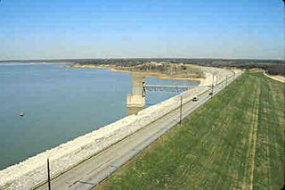
Grapevine Lake is an American reservoir located in the North Texas region, approximately 20 mi (32 km) northwest of Dallas and northeast of Fort Worth. It was impounded in 1952 by the US Army Corps of Engineers when they dammed Denton Creek, a tributary of Trinity River.

Albert "Benny" Benbrook was an American football guard who played for the University of Michigan Wolverines from 1908 to 1910. He was chosen by Walter Camp as a first-team All-American in 1909 and 1910 and was Michigan's team captain in 1910. He is considered one of the best college football linemen in the early years of the sport. He served in the military and later had a career in the office furniture and seating businesses. He was posthumously elected to the College Football Hall of Fame in 1971.

Josh Rosenthal is an American singer-songwriter based in Salt Lake City, Utah. He sings about reconciliation after his parents' divorce, general relationship hardships and his affection for Salt Lake City. His song "Gotta Get Out" is about Lubbock, Texas. He has played at protestant churches, Young Life camps and banquets as well as theaters and auditoriums across the United States. He got a college degree from the University of Utah in Humanities - Strategic Communication in 2009.

Lake Palestine is a freshwater lake in northeast Texas, created for industrial, municipal, and recreational purposes. It is an artificial lake formed in the early 1960s by the construction of the 5720-foot long Blackburn Crossing Dam on the Neches River. The project was started in 1960 and completed on June 13, 1962.
The resulting lake is 18 miles long, stretching northwest to southeast, with 135 miles of shoreline. The widest part of the lake is 4 miles across. According to the Texas Water Development Board 2012 Survey, the storage capacity of Lake Palestine is 367,312 acre-feet with a surface area of 23,112 acres at the conservation pool elevation of 345 feet above mean sea level. The drainage area above the dam is approximately 839 square miles.


