
Scissors is a census-designated place (CDP) in Hidalgo County, Texas. The population was 3,186 at the 2010 United States Census. It is part of the McAllen–Edinburg–Mission Metropolitan Statistical Area.
JJY is the call sign of a low frequency time signal radio station located in Japan.
Barroquinha is a community in the Brazilian state of Ceará. The population was estimated at 15,044 in 2020.
The Tule Desert is located in southeastern Nevada in Lincoln County, near the Utah state line. The desert lies northeast of the Mormon Mountains, south of the Clover Mountains and west of the Tule Springs Hills.

Readville is part of the Hyde Park neighborhood of Boston. Readville's ZIP Code is 02136. It was called Dedham Low Plains from 1655 until it was renamed after the mill owner James Read in 1847. It was part of Dedham until 1867. It is served by Readville station on the MBTA Commuter Rail. It is on the original alignment of Route 128, later part of a since-discontinued section of Route 135. Readville is bordered by the Town of Milton to the south and the Town of Dedham to the west. Paul's Bridge, which is at the neighborhood's entrance as one approaches Milton, is one of the oldest bridges in the Commonwealth. The name comes from James Read, a resident and cotton mill owner. Readville is covered by Boston Police Department District E-18 in Hyde Park and a fire station on Neponset Valley Parkway houses Boston Engine Company 49. Readville is also home to several light industries.

Emilia's short-tailed opossum is an opossum species from South America. It is found in Bolivia, Brazil and Peru.
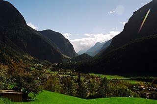
The Ötztal is an alpine valley located in Tyrol, Austria. The Ötztaler Ache river flows through the valley in a northern direction. The Ötztal separates the Stubai Alps in the east from the Ötztal Alps in the west. The valley is 65 km (40 mi) long. The northern end of the valley is at the confluence of the Ötztaler Ache and Inn rivers, 8 km east of Imst and 50 km west of Innsbruck. The only railway station of the valley, Ötztal railway station, is located here and connects the Ötztal with the Arlberg railway (Innsbruck-Bludenz) and also a motorway interchange to the A12 (E60).
The Callaghan Valley is located in the Sea to Sky Country of southwestern, British Columbia, in the Pacific Ranges of the Coast Mountains 90 km north of Vancouver. It was the home of the 2010 Winter Olympics's Whistler Olympic Park, the venue for the Nordic events of the Olympics, and adventure tourism operations including Canadian Wilderness Adventures.

Highway 66 is a north–south highway in the Jezreel Valley in northern Israel.
Wąsosz is a village in the administrative district of Gmina Końskie, within Końskie County, Świętokrzyskie Voivodeship, in south-central Poland. It lies approximately 8 kilometres (5 mi) south-east of Końskie and 31 km (19 mi) north of the regional capital Kielce.

Fortaleza de Minas is a Brazilian municipality located in the southwest of the state of Minas Gerais. Its population as of 2020 was 4,437 people living in a total area of 218 km2 (84 sq mi). The city belongs to the meso-region of Sul e Sudoeste de Minas and to the micro-region of Passos. It became a municipality in 1963.

Gołębiewo Średnie is a village in the administrative district of Gmina Trąbki Wielkie, within Gdańsk County, Pomeranian Voivodeship, in northern Poland. It lies approximately 4 kilometres (2 mi) south of Trąbki Wielkie, 16 km (10 mi) south-west of Pruszcz Gdański, and 27 km (17 mi) south of the regional capital Gdańsk.
Wysokie is a village in the administrative district of Gmina Choszczno, within Choszczno County, West Pomeranian Voivodeship, in north-western Poland. It lies approximately 4 kilometres (2 mi) south of Choszczno and 63 km (39 mi) south-east of the regional capital Szczecin.
Várzea da Roça is a municipality in the state of Bahia in the North-East region of Brazil.
São João Batista, Santa Catarina is a municipality in the state of Santa Catarina in the South region of Brazil.
Vražogrnci is a village in the municipality of Aleksandrovac, Serbia. According to the 2002 census, the village has a population of 297 people.
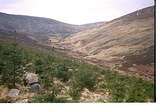
Corrigasleggaun at 794 metres (2,605 ft), is the 35th–highest peak in Ireland on the Arderin scale, and the 45th–highest peak on the Vandeleur-Lynam scale. Corrigasleggaun is situated in the southwestern sector of the Wicklow Mountains range, and is part of the large massif of Lugnaquilla 925 metres (3,035 ft), Wicklow's highest mountain. Corrigasleggaun lies at the head of the glen of the easterly flowing Carrawaystick River, which includes the scenic corrie lake of Kelly's Lough near its summit, and Carrawaystick Mountain at its base. Corrigasleggaun also lies alongside Lugnaquilla's South Prison, from which the River Ow flows south to the Aghavannagh Bridge.

County Road 5096 is a 9.2 kilometers (5.7 mi) long county road in Eidfjord Municipality in Vestland county, Norway. The road heads northeast from the village of Eidfjord. Prior to 2020, the road was called County Road 103. It was changed in 2020 when Vestland county was created.

Tonduff at 642 metres (2,106 ft), is the 169th–highest peak in Ireland on the Arderin scale, and the 202nd–highest peak on the Vandeleur-Lynam scale. Tonduff is in the far northeastern section of the Wicklow Mountains, in Wicklow, Ireland. The main flat summit is sometimes listed as Tonduff North, while the subsidiary summit, Tonduff East Top 593 metres (1,946 ft), is sometimes listed as Tonduff South. Tonduff East Top has a prominence of only 15 metres (49 ft), which just qualifies it as an Arderin Beg. A bog on the western slopes of Tonduff, the Liffey Head Bog, forms the source of the River Liffey; bogs on the southern slopes of Tonduff, forms the source of the River Dargle.