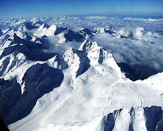
The Tödi, is a mountain massif and with the mountain peak Piz Russein the highest mountain in the Glarus Alps and the highest summit in the canton of Glarus, Switzerland. It is located on the border between the cantons of Graubünden, to the south, and Glarus, to the north, close to the point where those two cantons meet the canton of Uri, to the west. Although not the culminating point of Graubünden, it is its highest peak outside the Bernina range.

The Dom is a mountain of the Pennine Alps, located between Randa and Saas-Fee in the canton of Valais. With its 4,545 m (14,911 ft) summit it is the third highest mountain in the Alps and the second highest in Switzerland, after Monte Rosa. The Dom is the main summit of the Mischabel group, which is the highest massif lying entirely in Switzerland.

The Bertol Hut is a mountain hut overlooking the Bertol Pass, south of Arolla in the Swiss canton of Valais. It is known for its precarious position on a ridge at 3,311 metres (10,863 ft) south of the Pointe de Bertol and is accessed by a number of fixed ladders and chains from the glacier pass. All accesses to the hut involve glacier crossing. On its east side it overlooks the large plateau of the Mont Miné Glacier.
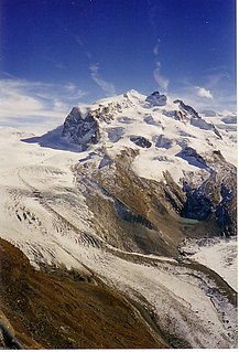
The Gorner Glacier is a valley glacier found on the west side of the Monte Rosa massif close to Zermatt in the canton of Valais, Switzerland. It is about 12.4 km (7.7 mi) long (2014) and 1 to 1.5 km wide. The entire glacial area of the glacier related to Gorner Glacier is 57 km2 (22 sq mi) (1999), which makes it the second largest glacial system in the Alps after the Aletsch Glacier system; however it ranks only third in length behind the Aletsch and Fiescher Glacier, respectively. Numerous smaller glaciers connect with the Gorner Glacier. Its (former) tributaries are : Gornergletscher, Monte Rosa Gletscher, Grenzgletscher, Zwillingsgletscher, Schwärzegletscher, Breithorngletscher, Triftjigletscher, and Unterer Theodulgletscher.

The Wildhorn is a mountain of the Alps, straddling the border between the Swiss cantons of Bern and Valais. At 3,248 metres (10,656 ft) above sea level, it is the highest summit of the Bernese Alps west of the Gemmi Pass. It forms a large glaciated massif, about 10 km wide, extending between the Sanetsch Pass and the Rawil Pass. Along with the Muverans, the Diablerets and the Wildstrubel, the Wildhorn is one the four distinct mountain massifs of the Bernese Alps that lie west of the Gemmi Pass. The massif of the Wildhorn is at the centre between the valleys of the Saane, Simme and the Rhone (Valais). It comprises several distinct summits, including the Arpelistock, Le Sérac, the Geltenhorn, the Sex Noir, the Sex Rouge, the Schnidehorn and the Six des Eaux Froides. The main crest is between the glaciers named Tungelgletscher and Glacier du Wildhorn. South of the main summit is the almost equally high summit of Mont Pucel. The Wildhorn is surrounded by several large mountain lakes: the Lac de Sénin, the Lauenensee, the Iffigsee, the Lac de Tseuzier and the Lac des Audannes. The Tungelgletscher, on the north-east face, was measured as 1.9 km in length in 1973.

The Konkordia Hut is a mountain hut of the Swiss Alpine Club, located north of Fieschertal in the canton of Valais. The hut lies above Konkordiaplatz, the point of convergence of several glaciers in the great Aletsch Glacier system of the Bernese Alps. It is located at a height of 2,850 metres above sea level, at the foot of the Fülbärg.
The Mönchsjoch Hut is a mountain hut located in the Bernese Alps in the canton of Valais in Switzerland. At an altitude of 3,658 metres (12,001 ft) is one of the highest huts owned by the Swiss Alpine Club.

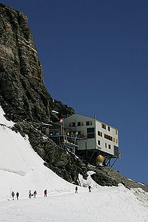
The Britannia Hut is a mountain hut of the Swiss Alpine Club, located south of Saas-Almagell in the canton of Valais. The hut lies at a height of 3,030 metres above sea level, at the foot of the Allalinhorn near the Allalin Glacier, in the Mischabel massif. It is a starting point for the ascents of Strahlhorn, Rimpfischhorn and Allalinhorn.

The Vignettes Hut is an alpine hut, located south of Arolla in the Swiss canton of Valais. It lies at a height of 3,160 metres above sea level, at the foot of the Pigne d'Arolla and near the Col de Chermotane in the Pennine Alps. All accesses to the hut involve glacier crossing.

The Finsteraarhorn Hut is a mountain hut of the Swiss Alpine Club, located north of Fieschertal in the canton of Valais. It lies at a height of 3,048 metres (10,000 ft) above sea level at the southern foot of the Finsteraarhorn, the highest peak of the Bernese Alps. The hut overlooks the upper basin of the Fiescher Glacier, which is among the largest of the range. It is located a few kilometres east of the Grünhornlücke.

The Hollandia Hut is a mountain hut of the Swiss Alpine Club, located east of Blatten in the canton of Valais. The hut lies at a height of 3,240 metres above sea level, just above the Lötschenlücke, the glacier pass connecting the Lötschental from the Aletsch Glacier. All accesses to the hut involve glacier crossing.

The Tschierva Hut is a mountain hut located in the Swiss canton of Graubünden at the foot of Piz Bernina, Piz Tschierva and Piz Morteratsch at the end of Val Roseg. The hut lies at 2,584 metres above sea level near the Tschierva Glacier and can be accessed from Pontresina via a trail. The hut is the starting point of the Biancograt, the serpentine north ridge of Piz Bernina.

The Pigne de la Lé is a mountain of the Swiss Pennine Alps, located south of Zinal in the canton of Valais. It lies north of the Grand Cornier, on the range between the Moiry Glacier and the valley of Zinal.
The Oberaarjoch Hut is a mountain hut of the Swiss Alpine Club, located north of Fieschertal in the canton of Valais, close to the canton of Bern. The hut lies at a height of 3,258 metres above sea level at the foot of the Oberaarhorn, just above the Oberaarjoch, the glacier pass connecting the Fiescher Glacier from the Oberaar Glacier. All accesses to the hut involve glacier crossing.

The Dent Blanche Hut is a mountain hut of the Swiss Alpine Club, located south of Les Haudères in the canton of Valais. The hut lies at a height of 3,507 metres above sea level, at the foot of the Dent Blanche in the Pennine Alps. The hut, located at the upper end of the valley of Hérens near the watershed with the valley of Zermatt, overlooks the Ferpècle Glacier.
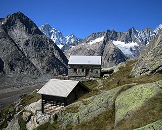
The Lauteraar Hut is a mountain hut of the Swiss Alpine Club, located south-west of Handegg in the canton of Bern. The hut lies at a height of 2,392 metres (7,848 ft) above sea level, above the Unteraar Glacier, at the foot of the Hienderstock in the Bernese Alps.

The Schreckhorn Hut is a mountain hut of the Swiss Alpine Club, located south of Grindelwald in the canton of Bern. The hut lies at a height of 2,529 metres above sea level, above the Lower Grindelwald Glacier, at the foot of the Schreckhorn in the Bernese Alps.

The Dix Hut is a mountain hut of the Swiss Alpine Club, located south of Hérémence in the canton of Valais. The hut lies above the Cheilon Glacier, at a height of 2,928 metres above sea level, approximately halfway between the Lac des Dix and the Mont Blanc de Cheilon.

The Rottal Hut is a mountain hut of the Swiss Alpine Club, located south of Lauterbrunnen in the canton of Bern. It lies at a height of 2,755 metres above sea level, above the Rottal Glacier on the western slopes of the Jungfrau.

The Mutthorn Hut is a mountain hut of the Swiss Alpine Club, located between Kandersteg and Lauterbrunnen in the canton of Bern. It lies at a height of 2,900 metres above sea level, above the watershed between the Kander Glacier and the Tschingel Glacier, at the foot of the Mutthorn.