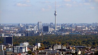
The Berliner Funkturm or Funkturm Berlin is a former broadcasting tower in Berlin. Constructed between 1924 and 1926 to designs by the architect Heinrich Straumer, it was inaugurated on 3 September 1926, on the occasion of the opening of the third Große Deutsche Funkausstellung in the grounds of the Messe Berlin trade fair in the borough of Charlottenburg-Wilmersdorf. Nicknamed der lange Lulatsch, the tower is one of the best-known points of interest in the city of Berlin and, while no longer used for broadcasting purposes, it remains a protected monument.

Swisscom-Sendeturm St. Chrischona is a communications tower built in 1980–1984 near Basel, Switzerland, on the territory of the municipality Bettingen, Basel-Stadt.

The Berlin-Müggelberge TV tower is the 31 metre tall base of a tower, never completed, in the Müggel hills of southeast Berlin, Germany. The tower base is currently used as radio relay link station.

Sender Zehlendorf is a radio transmission facility which has been in service since 1936, when a short wave transmitter was built in Zehlendorf as part of the establishment of permanent radio services. This Zehlendorf site, which until the end of World War II was referred to as the Rehmate Radio Transmission Centre, had 26 different antennas.
The Transmitter Stallupöner Allee, Berlin is a transmission site for medium wave radio broadcasts situated on the Stallupöner Allee in Berlin-Charlottenburg, Germany. This transmission site was established in 1948. It uses as aerial a 130 metre high guyed steel framework mast with triangular section, which is insulated against ground. Until 1998 there was a second insulated guyed steel framework mast on the site. It was replaced by a small freestanding steel framework tower. The transmission power of the medium wave transmitter was reduced during the nineties from 100 kilowatts to 2.5 kilowatts.
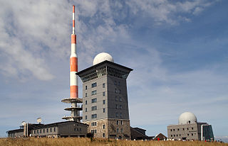
The Brocken Transmitter is a facility for FM- and TV-transmitters on the Brocken, the highest mountain in northern Germany.

The Sendeturm Jauerling is a tower for directional radio services, FM and TV broadcasting on the Jauerling mountain in Austria. Sendeturm Jauerling was built in 1958. It consists of a 35 metre high free-standing steel framework tower, which carries a guyed steel tube mast on the top and has a total height of 141 metres.

Flak towers were eight complexes of large, above-ground, anti-aircraft gun blockhouse towers constructed by Nazi Germany in the cities of Berlin (3), Hamburg (2), and Vienna (3) from 1940 onwards. Other cities that used flak towers included Stuttgart and Frankfurt. Smaller single-purpose flak towers were built at key outlying German strongpoints, such as at Angers in France, Helgoland in Germany and Trondheim, Norway.

Kurt-Schumacher-Platz is a station on the U 6 line of the Berlin U-Bahn. There is a bus link outside the station connecting Berlin's Tegel International Airport to the U-Bahn network. The station was opened on 3 May 1956 and named after famous German politician Kurt Schumacher.
Rocket Launch Site Berlin was the launch site of the Space Club in Berlin-Reinickendorf at 52°33' N and 13°18' E directly adjacent to the current site of the Airport Berlin-Tegel in an area that is now Cité Pasteur. It was inaugurated in September 1930, using the site and the buildings of a disused French ammunitions depot which Rudolf Nebel managed to rent from the Prussian war ministry.

Alt-Tegel is a Berlin U-Bahn station located on the U 6. It was constructed by B. Grimmek and opened as "Tegel" station in 1958. In 1992, the station was renamed to Alt-Tegel. Nearby is the S-Bahn station Berlin-Tegel, and the rename perhaps occurred to avoid confusion.

Otisstraße is a Berlin U-Bahn station located on the U 6.

Gartow-Höhbeck transmitter is a large facility for FM and TV transmission in Lower Saxony, Germany, situated behalf of the communities of Gartow and Höhbeck.

The Ochsenkopf Transmitter is a 163 metres (535 ft) radio and TV tower of reinforced concrete, which was built in 1958 on the summit of the 1,024 metres (3,360 ft) Ochsenkopf mountain, the second-highest mountain in the Fichtelgebirge mountain chain in Northern Bavaria, Germany. The tower replaced a 50 metres (160 ft) guyed steel tube TV mast that collapsed in January 1958 as result of icing. The tower, which is not accessible to the public, has a hyperbolic-shaped basement with five floors for technical equipment. Above it, there are platforms for directional antennas. The antennas for FM-transmission are on the upper part of the concrete tower, those for TV transmission on a steel tube mast on the top.

The Piątkowo transmitter is a facility for directional radio and broadcasting of local FM and TV programmes at Piątkowo, a northern residential district of the Polish city of Poznań. The Piątkowo transmitter, which is situated at 52°27′35″N16°54′27″E and property of the Polish company Emitel, consists of two towers of different height and construction type.
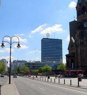
The Europa-Center is a building complex on Breitscheidplatz in the Charlottenburg district of Berlin, with a shopping mall and an 86 metres (282 ft) high-rise tower. Erected between 1963 and 1965, it is today a historically preserved building.

Berlin Tegel is a railway station in Tegel, a locality of the Reinickendorf borough of Berlin. It is served by the S-Bahn line S 25.

Heiligensee is a railway station in Heiligensee, a locality in the Reinickendorf borough of Berlin. It is served by the S-Bahn line S 25.

Emley Moor transmitting station is a telecommunications and broadcasting facility on Emley Moor, 1 mile (1.6 km) west of the village centre of Emley, in Kirklees, West Yorkshire, England, made up of a 1,084-foot-tall (330.4 m) concrete tower and apparatus which began transmitting in 1971. It is protected under UK law as a Grade II listed building. It is the tallest freestanding structure in the United Kingdom, seventh-tallest freestanding structure and fourth-tallest tower in Europe outside Russia, and 24th-tallest tower in the world.