
The ruins of Cargill's Castle stand on a promontory overlooking the Pacific Ocean in New Zealand's southern city of Dunedin. It is one of about ten castles in New Zealand, the other one in Otago being nearby Larnach Castle. More a castle in name than in fact, this Italianate mansion was built for Edward Cargill, eighth child of city founder William Cargill, in the late 19th century, who called it The Cliffs. Designed by the young architect Francis Petre, and built in concrete by Harry Lyders at a cost of £14,000, it was completed in 1877. Several kilometres south of the castle is Tunnel Beach, so named because this quiet beach is only accessible through a steeply sloping tunnel cut into the 60 metres (200 ft) high cliffs by the Cargill family. It is also very likely that Petre was the supervisor of the construction of the tunnel. While designing the house, Petre fell in love with Cargill's daughter Margaret. After a difficult courtship the couple were eventually permitted to marry, the wedding taking place in the villa's principal salon on 1 March 1881.
Dunedin is a city of 130,500 people in the South Island of New Zealand. The principal suburbs of Dunedin are as follows. Inner and outer suburbs are ordered by location, clockwise from the city centre, starting due north:

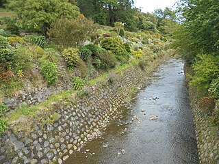
The Water of Leith, is a small river in the South Island of New Zealand.

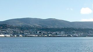
Mount Cargill, known in Māori as Kapukataumahaka, is a volcanic outcrop which dominates the skyline of northern Dunedin, New Zealand.
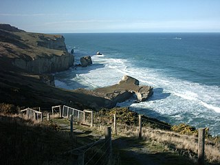
Tunnel Beach is a locality 7.5 kilometres (4.7 mi) southwest of the city centre of Dunedin, New Zealand. Located just south of St Clair, Tunnel Beach has sea-carved sandstone cliffs, rock arches and caves. Beyond the beauty of the rugged sandstone cliffs, its claim to fame is the tunnel down to the beach that a local politician, John Cargill, son of Captain William Cargill, had commissioned for his family in the 1870s. Local legend says that one or more of Cargill's daughters drowned while swimming at the beach, but there is no truth to this story.
Flagstaff, known in Māori as Te Whanaupaki, is a prominent hill overlooking the northwest of the city of Dunedin, in New Zealand's South Island. Together with Mount Cargill, which lies to its northeast, it dominates the skyline of the city. Flagstaff lies seven kilometres to the north of Dunedin's city centre.

Pine Hill is a suburb, hill, and general area of the New Zealand city of Dunedin. It is sited on the hill of the same name, a spur of Mount Cargill overlooking North East Valley and Glenleith 4 kilometres (2.5 mi) to the north of the city centre. This spur lies in the fork of the confluence of the Water of Leith and its largest tributary, the Lindsay Creek. The term Pine Hill is used generally to refer to a group of suburbs which lie on the hill's slopes: Pine Hill suburb itself, which sits on the upper slopes of the spur, and also two other suburbs which lie on the lower slopes, Dalmore and Liberton. The combined population of these suburbs in 2001 was 2,259.

North East Valley is a suburb of the New Zealand city of Dunedin.

St Clair is a leafy residential suburb of Dunedin, New Zealand. It is located on the Pacific Ocean coast five kilometres from the city centre on the southwesternmost part of the coastal plain which makes up the southern part of the urban area, and also climbs the slopes of Forbury Hill immediately to the west of this plain. St Clair's 2001 population was 4,179.

Sawyers Bay is a suburb of the New Zealand city of Dunedin. It is located 3 kilometres (1.9 mi) to the southwest of Port Chalmers in a wide valley on the shore of Mussel Bay, 13 kilometres (8.1 mi) to the northeast of Dunedin city centre.
Opoho is a suburb of the New Zealand city of Dunedin. It sits on the western flank of Signal Hill, New Zealand, 3 kilometres (1.9 mi) to the northeast of the city centre, overlooking North East Valley and the Dunedin Botanic Gardens.
South Dunedin is a major inner city suburb of the New Zealand city of Dunedin. It is located, as its name suggests, 2.5 kilometres (1.6 mi) to the south of the city centre, on part of a large plain known locally simply as "The Flat". The suburb is a mix of industrial, retail, and predominantly lower-quality residential properties.
Calton Hill is an elevated southern residential suburb of the City of Dunedin in New Zealand's South Island. The suburb is named after Calton Hill in Edinburgh, Scotland, and some of its street names carry similar etymological roots. It covers an area of approximately 80 hectares and has 627 households comprising 1583 residents.
Kensington is a small suburb of the New Zealand city of Dunedin, nestled to the south of a hilly spur between the central city and the major suburb of South Dunedin, some 2.4 kilometres (1.5 mi) to the south of the city centre. The suburb was named for the leafy London suburb, possibly by John Hyde Harris, who subdivided the area in the 1860s.
Brockville is a residential suburb of the New Zealand city of Dunedin. It is located at the edge of the city's main urban area, 5.5 kilometres (3.4 mi) to the northwest of the city centre, but separated from it by both a ridge of hills and the Kaikorai Valley.
Shiel Hill is a residential suburb of the New Zealand city of Dunedin. It is located at the southeastern edge of the city's urban area, 3.2 kilometres (2.0 mi) southeast of the city's centre at the western end of the Otago Peninsula, close to the isthmus joining the peninsula to the mainland. As the name suggests, it is situated on the slopes of a hill at the start of the ridge which runs along the spine of the peninsula. The slopes rise to a series of crests generally known collectively as Highcliff, a name also often applied to the last suburban vestiges which remain as Dunedin's urban area becomes the rural land of the peninsula. More accurately, the name is that of a cliff which lies on the Pacific coast of the peninsula 4 kilometres (2.5 mi) east of Shiel Hill.

The Southern Cemetery in the New Zealand city of Dunedin was the first major cemetery to be opened in the city. The cemetery was opened in 1858, ten years after the founding of the city in an area known as Little Paisley. This area lies at the southern end of Princes Street, one of the city's main streets, close to the suburbs of Kensington, Maryhill, and The Glen.
Leith Valley is a suburb, valley, and general area of the New Zealand city of Dunedin, located to the northwest of the city centre. To differentiate the name of the valley from that of the suburb, the former is usually referred to as the Leith Valley, the latter simply as Leith Valley.
The Lindsay Creek is a tributary of the Water of Leith which runs through the northern suburbs of Dunedin, New Zealand. The Māori name Puke-haukea has been attributed to the creek; however, as puke means a hill, not a watercourse, this is likely to be a confusion.
Swampy Summit is a prominent hill 12 kilometres (7.5 mi) to the north of Dunedin, New Zealand. It reaches a height of 739 metres (2,425 ft).
