A village development committee in Nepal was the lower administrative part of its Ministry of Federal Affairs and Local Development. Each district had several VDCs, similar to municipalities but with greater public-government interaction and administration. There were 3,157 village development committees in Nepal. Each village development committee was further divided into several wards depending on the population of the district, the average being nine wards.
The 1991 Nepal census was a widespread national census conducted by the Nepal Central Bureau of Statistics.
Sutar is a village in Achham District in the Seti Zone of western Nepal. At the time of the 1991 Nepal census, the village had a population of 2697 living in 473 houses. At the time of the 2001 Nepal census, the population was 3026, of which 24% was literate.
Pagretar is a village development committee in Sindhupalchowk District in the Bagmati Zone of central Nepal. Kothe is a populated location within the committee area. In 1991, there were 633 houses, and at the time of the 2001 Nepal census Pagretar had a population of 3,352. By 2011, the population had become 2,952 in 762 households.
Gurukhola is a village development committee (VDC) in Baitadi District in the Mahakali Zone of western Nepal. At the time of the 1991 Nepal census it had a population of 3,481 and had 600 houses in the town.
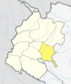
Mahakali is a village development committee in Baitadi District in the Mahakali Zone of western Nepal. It is located on the Mahakali River which is also the border with Uttarakhand state, India across from Jhulaghat. Amraad and Basku are main places in this village. Indian and Nepalese nationals cross without restrictions, however there is a customs checkpoint for goods.
Srikot is a village development committee in Baitadi District in the Mahakali Zone of western Nepal. At the time of the 1991 Nepal census it had a population of 3,076 and had 498 houses in the village.
Satungal is a village and former Village Development Committee that is now part of Chandragiri Municipality in Kathmandu District in Province No. 3 of central Nepal. Satungal is also known as Satyapur. At the time of the 1991 Nepal census it had a population of 2,730 people living in 464 households. By the time of the 2001 Nepal census the population had grown to 5,834, spread over 1,375 households. At that time 5,173 of the village population were literate - a literacy rate of 88.7%.
Naubasta is a town in Banke District in the Bheri Zone of south-western Nepal. At the time of the 1991 Nepal census it had a population of 11,160 and had 1663 houses in the town.

Dolalghat is a village development committee in Kabhrepalanchok District in Bagmati Province of central Nepal.
Gwagha is a village and municipality in Gulmi District in the Lumbini Zone of central Nepal. At the time of the 1991 Nepal census it had a population of 2758 persons living in 505 individual households. It is notable for a vicious attack by tigers in 1985 in which all but three inhabitants were mauled and killed. The remaining three were left to rebuild and repopulate the municipality, saving the community, fabled for having taller women than men from extinction.
Saudiyar is a town and Village Development Committee in Dang Deokhuri District in Lumbini Province of south-western Nepal. At the time of the 1991 Nepal census it had a population of 8,052 persons living in 1067 individual households.
Bhakunde is a village development committee in Baglung District in the Dhawalagiri Zone of central Nepal. At the time of the 1991 Nepal census it had a population of 3,833 and had 697 houses in the village. At the time of the 2011 Nepal census it had a population of 4,952 among which 2,443 were female and 2,509 were male. There were about 831 houses in the village.
Pokhariya is a municipality in Parsa District in the Narayani Zone of southern Nepal. At the time of the 2011 Nepal census it had a population of 6,995 people living in 1,015 individual households.
Kajarhawa is a village in Kapilvastu District in the Lumbini Province of southern Nepal. At the time of the 2001 Nepal census it had a population of 3438 people living in 571 individual households.
Pathari Shanishchare (पथरी-शनिश्चरे) is a Municipality in Morang District in the Koshi Zone of south-eastern Nepal. It was formed by merging three existing village development committees i.e. Hasandaha, Pathari and Sanischare in May 2014.
Nepal conducted a widespread national census in 2011 by the Nepal Central Bureau of Statistics. Working with the 58 municipalities and the 3,915 Village Development Committees at a district level, they recorded data from all the municipalities and villages of each district. The data included statistics on population size, households, sex and age distribution, place of birth, residence characteristics, literacy, marital status, religion, language spoken, caste/ethnic group, economically active population, education, number of children, employment status, and occupation.
The 2001 Nepal census was conducted by the Nepal Central Bureau of Statistics. According to the census, the population of Nepal in 2001 was 23,151,423. Working with Nepal's Village Development Committees at a district level, they recorded data from all the main towns and villages of each district of Nepal. The data included statistics on population size, households, sex and age distribution, place of birth, residence characteristics, literacy, marital status, religion, language spoken, caste/ethnic group, economically active population, education, number of children, employment status, and occupation.
Kamalbazar is a municipality in Achham District in Sudurpashchim Province of Nepal that was established on 18 September 2015 by merging the former Village development committees Bayala, Dhaku,Birpath, Chalsa, Sera, Muli and Mashtabandali and Kuika. Kamalbazar is a trade centre for East Achham. It also has a Primary Health Center and some banking facilities, which benefit locals, as they previously had to go the district headquarter Mangalsen to use such services. Wind energy facilities and solar power facilities support the local power supply.. Administrative offices are located in the former Bayala.