In neoclassical economics, economic rent is any payment to the owner of a factor of production or resource, supply of which is fixed. In classical economics, economic rent is any payment made or benefit received for non-produced inputs such as location (land) and for assets formed by creating official privilege over natural opportunities. In the moral economy of neoclassical economics, economic rent includes income gained by labor or state beneficiaries of other "contrived" exclusivity, such as labor guilds and unofficial corruption.
Imputed rent is the rental price an individual would pay for an asset they own. The concept applies to any capital good, but it is most commonly used in housing markets to measure the rent homeowners would pay for a housing unit equivalent to the one they own. Imputing housing rent is necessary to measure economic activity in national accounts. Because asset owners do not pay rent, owners' imputed rent must be measured indirectly.
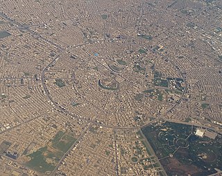
Urban structure is the arrangement of land use in urban areas, in other words, how the land use of a city is set out. Urban planners, economists, and geographers have developed several models that explain where different types of people and businesses tend to exist within the urban setting. Urban structure can also refer to urban spatial structure, which concerns the arrangement of public and private space in cities and the degree of connectivity and accessibility.
Urban economics is broadly the economic study of urban areas; as such, it involves using the tools of economics to analyze urban issues such as crime, education, public transit, housing, and local government finance. More specifically, it is a branch of microeconomics that studies the urban spatial structure and the location of households and firms.
The term inner city has been used, especially in the United States, as a euphemism for majority-minority lower-income residential districts that often refer to rundown neighborhoods, in a downtown or city centre area. Sociologists sometimes turn the euphemism into a formal designation by applying the term inner city to such residential areas, rather than to more geographically central commercial districts, often referred to by terms like downtown or city centre.

Carl David Alfred Weber was a German economist, geographer, sociologist, philosopher, and theoretician of culture whose work was influential in the development of modern economic geography. His other work focused on the sociology of knowledge and the role of intellectuals in society. In particular, he introduced the concept of free-floating intelligentsia.

The concentric zone model, also known as the Burgess model or the CCD model, is one of the earliest theoretical models to explain urban social structures. It was created by sociologist Ernest Burgess in 1925.

The multiple nuclei model is an economical model created by Chauncy Harris and Edward Ullman in the 1945 article "The Nature of Cities".

Johann Heinrich von Thünen, sometimes spelled Thuenen, was a prominent nineteenth-century economist and a native of Mecklenburg-Strelitz, now in northern Germany.
Pay-per-click (PPC) is an internet advertising model used to drive traffic to websites, in which an advertiser pays a publisher when the ad is clicked.
Land-use forecasting undertakes to project the distribution and intensity of trip generating activities in the urban area. In practice, land-use models are demand-driven, using as inputs the aggregate information on growth produced by an aggregate economic forecasting activity. Land-use estimates are inputs to the transportation planning process.
A peak land value intersection is the region within a settlement with the greatest land value and commerce.

The First Law of Geography, according to Waldo Tobler, is "everything is related to everything else, but near things are more related than distant things." This first law is the foundation of the fundamental concepts of spatial dependence and spatial autocorrelation and is utilized specifically for the inverse distance weighting method for spatial interpolation and to support the regionalized variable theory for kriging. The first law of geography is the fundamental assumption used in all spatial analysis.
Location theory has become an integral part of economic geography, regional science, and spatial economics. Location theory addresses questions of what economic activities are located where and why. Location theory or microeconomic theory generally assumes that agents act in their own self-interest. Firms thus choose locations that maximize their profits and individuals choose locations that maximize their utility.
Friction of distance is a core principle of geography that states that movement incurs some form of cost, in the form of physical effort, energy, time, and/or the expenditure of other resources, and that these costs are proportional to the distance traveled. This cost is thus a resistance against movement, analogous to the effect of friction against movement in classical mechanics. The subsequent preference for minimizing distance and its cost underlies a vast array of geographic patterns from economic agglomeration to wildlife migration, as well as many of the theories and techniques of spatial analysis, such as Tobler's first law of geography, network routing, and cost distance analysis. To a large degree, friction of distance is the primary reason why geography is relevant to many aspects of the world, although its importance has been decreasing with the development of transportation and communication technologies.
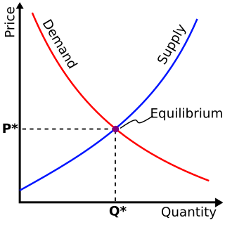
The law of rent states that the rent of a land site is equal to the economic advantage obtained by using the site in its most productive use, relative to the advantage obtained by using marginal land for the same purpose, given the same inputs of labor and capital.
Rental value is the fair market value of property while rented out in a lease. More generally, it may be the consideration paid under the lease for the right to occupy, or the royalties or return received by a lessor (landlord) under a license to real property. In the science and art of appraisal, it is the amount that would be paid for rental of similar real property in the same condition and in the same area.

The Core frame model is a model showing the urban structure of the Central Business District of a town or city. The model was first suggested by Ronald R. Boyce and Edgar M. Horwood in 1959.
The rent-gap theory was developed in 1979 by the geographer Neil Smith as an economic explanation for the process of gentrification. It describes the disparity between the current rental income of a property and the potentially achievable rental income. From this difference arises the interest of investors to renovate blocks or entire neighborhoods, resulting in an increase in rents and real estate value.

Morphology in architecture is the study of the evolution of form within the built environment. Often used in reference to a particular vernacular language of building, this concept describes changes in the formal syntax of buildings and cities as their relationship to people evolves and changes. Often morphology describes processes, such as in the evolution of a design concept from first conception to production, but can also be understood as the categorical study in the change of buildings and their use from a historical perspective. Similar to genres of music, morphology concertizes 'movements' and arrives at definitions of architectural 'styles' or typologies. Paradoxically morphology can also be understood to be the qualities of a built space which are style-less or irreducible in quality.
