Bifoun

Last updated
Bifoun
Gabon location map.svg
Red pog.svg
Bifoun
Location in Gabon
Coordinates: 0°20′0″N10°23′00″E / 0.33333°N 10.38333°E / 0.33333; 10.38333
Country Flag of Gabon.svg Gabon
Province Moyen-Ogooué
Department Abanga-Bigne Department

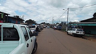
Bifoun is a town located in Moyen-Ogooué province, Gabon. It lies on the intersection between the N1 and N2 roads. The town is split by the N1 road from Libreville.

Gabon country in Africa

Gabon, officially the Gabonese Republic, is a country on the west coast of Central Africa. Located on the equator, Gabon is bordered by Equatorial Guinea to the northwest, Cameroon to the north, the Republic of the Congo on the east and south, and the Gulf of Guinea to the west. It has an area of nearly 270,000 square kilometres (100,000 sq mi) and its population is estimated at 2 million people. Its capital and largest city is Libreville.

The N1 road of Gabon is a road that runs from Libreville to Moumba that takes approximately 12 hours to drive. The portion of the road from Ndendé to the border with Congo-Brazzaville is traveled infrequently due to the instability in the latter country. However, it usually takes approximately two hours to reach the border.

The N2 road is one of the national highways of Gabon. It connects to the north and across into Cameroon.

The road is surrounded by farmlands with agricultural produce including grapefruits, mandarin oranges, as well as ground nuts. Beyond the farmlands lies the rainforest.

The N1 and N2 intersection lies on the south-east of the town. While the N1 goes southwards into Lambaréné, the N2 follows the path to Ndjolé.

Lambaréné Place in Moyen-Ogooué, Gabon

Lambaréné is a town and the capital of Moyen-Ogooué in Gabon. With a population of 38,775 as of 2013, it is located 75 kilometres south of the equator.

Ndjolé Place in Moyen-Ogooué Province, Gabon

Ndjolé is the capital town in the Abanga-Bigne Department in Gabon, lying northeast of Lambaréné on the Ogooué River, the N2 road and the Trans-Gabon Railway. It is known as a base for logging and as a transport hub. Ndjolé is the last city that can be reached by barge traffic traveling up the Ogooué River. Above Ndjolé there are rapids on the river.

Coordinates: 0°20′S10°23′E / 0.333°S 10.383°E / -0.333; 10.383

Geographic coordinate system Coordinate system

A geographic coordinate system is a coordinate system that enables every location on Earth to be specified by a set of numbers, letters or symbols. The coordinates are often chosen such that one of the numbers represents a vertical position and two or three of the numbers represent a horizontal position; alternatively, a geographic position may be expressed in a combined three-dimensional Cartesian vector. A common choice of coordinates is latitude, longitude and elevation. To specify a location on a plane requires a map projection.

Related Research Articles

Farmland, Indiana Town in Indiana, United States

Farmland is a town in Monroe Township, Randolph County, in the U.S. state of Indiana. The population was 1,333 at the 2010 census.

Novi Marof Town in Varaždin, Croatia

Novi Marof is a town in north-western Croatia, located south of Varaždin and east of Ivanec, in the Varaždin County. It lies on intersection of state roads D3 and D24 and is also connected with highway A4, state road D22 and R201 railway.

State Route 56 is a 164-mile (265 km) highway that runs south to north in Middle Tennessee.

Abakaliki Place in Ebonyi State, Nigeria

Abakaliki is the capital city of the present-day Ebonyi State in southeastern Nigeria, located 64 kilometres (40 mi) southeast of Enugu. The inhabitants are primarily members of the Igbo nation. It was the headquarters of the Ogoja province before the creation of the Southeastern State in 1967.

Babín municipality of Slovakia

Babín is a village and municipality in Námestovo District in the Žilina Region of northern Slovakia.

Maryland Route 333 highway in Maryland

Maryland Route 333 is a state highway in the U.S. state of Maryland. The state highway runs 9.79 miles (15.76 km) from the terminal of the seasonal Oxford–Bellevue Ferry in Oxford north to Washington Street in Easton within southwestern Talbot County. MD 333 was constructed between Trippe Creek and Easton in the 1910s. The highway was extended to Oxford in the late 1920s. In Easton, MD 333 was assigned to the southern part of Washington Street between 1948 and 1959 after U.S. Route 213 bypassed the town.

State Route 333 , is a south-to-north secondary highway in Blount County, Tennessee, that is 14.49 miles (23.3 km) long. Its southern terminus is with US Route 321 and State Route 73 near Friendsville, and its northern terminus is with US Route 129 in Alcoa.

Tennessee State Route 66 highway in Tennessee

State Route 66 is a state-maintained highway in eastern Tennessee, including a six-lane divided highway segment in Sevier County and a two-lane segment through mountainous terrain to the northeast.

U.S. Route 50 in Indiana highway in Indiana

U.S. Route 50 (US 50) is a part of the United States Numbered Highway System that runs from West Sacramento, California, to Ocean City, Maryland. In the U.S. state of Indiana, it is part of the state road system. US 50 enters the state in Vincennes. The 171.38 miles (275.81 km) of US 50 that lie within Indiana serve as a major conduit. All of the highway is listed on the National Highway System. Various sections are rural two-lane highway, urbanized four-lane undivided highway and one-way streets. The easternmost community along the highway is Lawrenceburg at the Ohio state line. US 50 passes through urban areas, farmland and woodland.

Kouka Department Department in Banwa Province, Burkina Faso

Kouka is a department or commune of Banwa Province in western Burkina Faso. Its capital lies at the town of Kouka. According to the 1996 census the department has a total population of 53,415.

Domiechowice Village in Łódź, Poland

Domiechowice is a village in the administrative district of Gmina Bełchatów, within Bełchatów County, Łódź Voivodeship, in central Poland. It lies approximately 3 kilometres (2 mi) north-west of Bełchatów and 46 km (29 mi) south of the regional capital Łódź.

Kalagi, Mukono Place in Mukono District, Uganda

Kalagi is a town in Mukono District in the Central Region of Uganda.

U.S. Route 129 is a north–south United States highway that runs for 52.8 miles (85.0 km) in East Tennessee, from the North Carolina state line, near Tapoco, to Knoxville. In Tennessee, the highway is completely overlapped by unsigned State Route 115 .

Waikiwi is a suburb of Invercargill, Southland, New Zealand. Invercargill is the southernmost city of New Zealand.

State Road 81 is a state highway linking State Road 20 at Bruce with Alabama State Route 87.

North Carolina Highway 118 highway in North Carolina

North Carolina Highway 118 (NC 118) is an 18.5-mile-long (29.8 km) primary state highway in the U.S. state of North Carolina. It runs east–west from NC 11 in Grifton to NC 43 in Vanceboro.

Tennessee State Route 49 highway in Tennessee

State Route 49 is a state highway in Tennessee. The route forms a broad southern arc that passes through the rural Middle Tennessee towns of Dover, Erin, Charlotte, Ashland City, Pleasant View, and Springfield.

State Route 32 is a state highway in East Tennessee. For most of its route, it is an unsigned companion route concurrent with US 25E.

State Route 113 is a north-south state highway in East Tennessee.

State Route 50 (SR 50) is a west–to–east highway in Middle Tennessee. The road begins near Only and ends in Altamont. The current length is 161.3 miles (259.6 km).

References