Related Research Articles

Año Nuevo State Park is a state park of California, United States, encompassing Año Nuevo Island and Año Nuevo Point, which are known for their pinniped rookeries. Located in San Mateo County, the low, rocky, windswept point juts out into the Pacific Ocean about 55 miles (89 km) south of San Francisco and the Golden Gate. Año Nuevo State Natural Reserve, formerly a separate unit of the California state park system, was merged into Año Nuevo State Park in October 2008. The coastal geographic center, or coastal-midpoint of California is located at the northern end of this park at 37°09′58″N122°21′40″W, as the absolute geographic center of California falls at 37°09′58″N119°26′58″W.

Moore Dry Dock Company was a ship repair and shipbuilding company in Oakland, California. In 1905, Robert S. Moore, his brother Joseph A. Moore, and John Thomas Scott purchased the National Iron Works located in the Hunter's Point section of San Francisco, and founded a new company, the Moore & Scott Iron Works Moore had previously been vice president of the Risdon Iron Works of San Francisco. Scott was nephew to Henry T. and Irving M. Scott, owners of the nearby Union Iron Works, where John had risen from apprentice to superintendent. Their new business was soon destroyed by fire resulting from the San Francisco earthquake.
Swanton is a small community in an unincorporated area of Santa Cruz County on the Pacific coast, situated about 5 miles (8.0 km) north of the town of Davenport, to the east of State Route 1 on Swanton Road. The US Geological Survey designates Swanton as a populated place located at latitude and longitude 37.06417°N 122.22639°W with an elevation of 135 ft (41 m). The ZIP Code is 95017 and the community is inside area code 831.

Sunvalley Shopping Center, or more popularly Sunvalley Mall, is a regional shopping center located in Concord, California. Located off Interstate 680, Sunvalley is owned and operated by the Taubman Company and is anchored by two Macy's locations, JCPenney, and Sears. The total square footage of the mall is 1.333 million square feet.

San Leandro Bay is a body of water in the San Francisco Bay. It is connected to the Oakland Estuary today, but was originally separated by land which formerly connected Alameda with Oakland. It is located along the east of the Oakland International Airport and Bay Farm Island. The principal stream which flows into San Leandro Bay is San Leandro Creek. Other tributaries include the East Creek/Peralta Creek watershed and the Lion Creek/Arroyo Viejo watershed. Damon Marsh is located there.
Honsinger Creek is a 3.6-mile-long (5.8 km) stream in San Mateo County, California, and a tributary of Pescadero Creek.
Little Chicken Hollow is a valley in San Mateo County, California. It contains a stream which is a fork of Honsinger Creek.
Recreation Park was the name applied to several former baseball parks in San Francisco, California in the late 19th century and early 20th century.
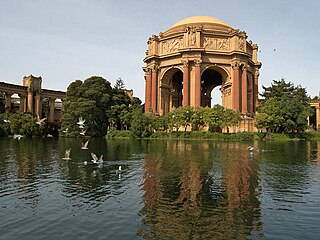
The Marina District is a neighborhood located in San Francisco, California. The neighborhood sits on the site of the 1915 Panama–Pacific International Exposition, staged after the 1906 San Francisco earthquake to celebrate the reemergence of the city. Aside from the Palace of Fine Arts, all other buildings were demolished to make the current neighborhood.

Año Nuevo State Marine Conservation Area (SMCA) is one of two adjoining marine protected areas off the coast of San Mateo and Santa Cruz Counties, on California’s central coast. The area is approximately 55 miles (89 km) south of San Francisco. The SMCA has an area of 11.07 square miles (28.7 km2). Except for limited taking of giant kelp, all living marine resources are protected.
El Polín Spring is a natural spring in San Francisco, California located in the Presidio. It is the source of the central tributary of El Polín Creek. The spring was used by the Ohlone people, the Spanish military, and the U.S. Army as a freshwater source. Much of the stream was channelized or placed in underground culverts, and many riparian areas were used for landfill. Beginning in the 2000s, the Presidio Trust has worked to rehabilitate El Polín spring and daylight sections of the creek downstream. In 2005, 77,000 tons of landfill were removed from Thompson Reach, a downstream section, and native riparian species were planted. In 2011, El Polín was restored, with new trails, native plants, and a picnic area installed.
Tamalpais Valley is an unincorporated community in Marin County, California.

Montara State Marine Reserve (SMR) and Pillar Point State Marine Conservation Area (SMCA) are two adjoining marine protected areas that extend offshore from Montara to Pillar Point in San Mateo County on California’s north central coast. The combined area of these marine protected areas is 18.42 square miles (47.7 km2), with 11.76 square miles (30.5 km2) in the SMR and 6.66 in the SMCA. Montara SMR prohibits the take of all living marine resources. Pillar Point SMCA prohibits the take of all living marine resources, except the recreational and commercial take of pelagic finfish by trolling or seine, the commercial or recreational take of Dungeness crab by trap and the commercial or recreational take or market squid by hand-held dip net or round haul net.

Museo ItaloAmericano, also known as the Italian American Museum, is a museum in San Francisco, California, that focuses on Italian-American history, art and culture.

Greyhound Rock State Marine Conservation Area (SMCA) is one of two adjoining marine protected areas off the coast of San Mateo County and Santa Cruz County, on California's central coast. The area is approximately 55 miles (89 km) south of San Francisco. The SMCA is 11.81 square miles (30.6 km2). Within the SMCA fishing and take of all living marine resources is prohibited except the recreational take of giant kelp, squid, salmon, and other finfish, subject to various conditions. Also permitted is the commercial take of giant kelp, salmon, and squid, subject to various conditions.
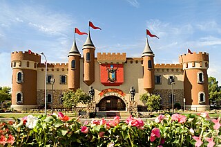
Golfland Entertainment Centers are a chain of family amusement centers, miniature golf courses, and water parks located in California and Arizona. The company was founded in 1953.
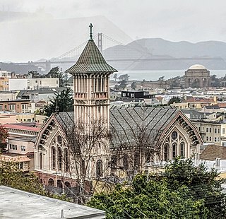
St. Vincent de Paul Church in San Francisco, California, is a Roman Catholic parish situated in Cow Hollow, located at 2320 Green St..

Nob Hill is a neighborhood of San Francisco, California, United States that is known for its numerous luxury hotels and historic mansions. Nob Hill has historically served as a center of San Francisco's upper class. Nob Hill is among the highest-income neighborhoods in the United States, as well as one of the most desirable and expensive real estate markets in the country. Prior to Covid-19, it was the most expensive real estate market per metre squared, narrowly beating Monte Carlo, although it has since fallen heavily. It was the only place in the United States so far where market price per square metre exceeded the average yearly salary in the country.

Sorich Park is in San Anselmo, California, US. It has trails leading into the surrounding hills and ridge line. The park borders the western part of central San Rafael, California, as well as Sleepy Hollow.
Atelier Crenn is a French restaurant in the Cow Hollow neighborhood in San Francisco, California. Opened in 2011 by Dominique Crenn and Juan Contreras, the restaurant became the seventh restaurant in the San Francisco Bay Area to be awarded three Michelin stars by the Michelin Guide in 2018.