Related Research Articles

The history of the petroleum industry in the United States goes back to the early 19th century, although the indigenous peoples, like many ancient societies, have used petroleum seeps since prehistoric times; where found, these seeps signaled the growth of the industry from the earliest discoveries to the more recent.

The Salt Creek Oil Field is located in Natrona County, Wyoming. By 1970, more oil had been produced by this field than any other in the Rocky Mountains region and accounted for 20 percent of the total production in Wyoming.
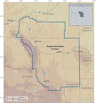
The Powder River Basin is a geologic structural basin in southeast Montana and northeast Wyoming, about 120 miles (190 km) east to west and 200 miles (320 km) north to south, known for its extensive coal reserves. The former hunting grounds of the Oglala Lakota, the area is very sparsely populated and is known for its rolling grasslands and semiarid climate.

The Denver Basin, variously referred to as the Julesburg Basin, Denver-Julesburg Basin, or the D-J Basin, is a geologic structural basin centered in eastern Colorado in the United States, but extending into southeast Wyoming, western Nebraska, and western Kansas. It underlies the Denver-Aurora Metropolitan Area on the eastern side of the Rocky Mountains.

Petroleum production in Canada is a major industry which is important to the overall economy of North America. Canada has the third largest oil reserves in the world and is the world's fourth largest oil producer and fourth largest oil exporter. In 2019 it produced an average of 750,000 cubic metres per day (4.7 Mbbl/d) of crude oil and equivalent. Of that amount, 64% was upgraded from unconventional oil sands, and the remainder light crude oil, heavy crude oil and natural-gas condensate. Most of the Canadian petroleum production is exported, approximately 600,000 cubic metres per day (3.8 Mbbl/d) in 2019, with 98% of the exports going to the United States. Canada is by far the largest single source of oil imports to the United States, providing 43% of US crude oil imports in 2015.

The East Texas Oil Field is a large oil and gas field in east Texas. Covering 140,000 acres (57,000 ha) and parts of five counties, and having 30,340 historic and active oil wells, it is the second-largest oil field in the United States outside Alaska, and first in total volume of oil recovered since its discovery in 1930. Over 5.42 billion barrels (862,000,000 m3) of oil have been produced from it to-date. It is a component of the Mid-continent oil province, the huge region of petroleum deposits extending from Kansas to New Mexico to the Gulf of Mexico.
The Canadian petroleum industry arose in parallel with that of the United States. Because of Canada's unique geography, geology, resources and patterns of settlement, however, it developed in different ways. The evolution of the petroleum sector has been a key factor in the history of Canada, and helps illustrate how the country became quite distinct from her neighbour to the south.

The San Juan Basin is a geologic structural basin located near the Four Corners region of the Southwestern United States. The basin covers 7,500 square miles and resides in northwestern New Mexico, southwestern Colorado, and parts of Utah and Arizona. Specifically, the basin occupies space in the San Juan, Rio Arriba, Sandoval, and McKinley counties in New Mexico, and La Plata and Archuleta counties in Colorado. The basin extends roughly 100 miles (160 km) N-S and 90 miles (140 km) E-W.
Türkiye Petrolleri Anonim Ortaklığı (TPAO) was founded in 1954 by Law No. 6327 with the responsibility of being involved in hydrocarbon exploration, drilling, production, refinery and marketing activities of oil and gas in Turkey as the national company.

The Williston Basin is a large intracratonic sedimentary basin in eastern Montana, western North Dakota, South Dakota, southern Saskatchewan, and south-western Manitoba that is known for its rich deposits of petroleum and potash. The basin is a geologic structural basin but not a topographic depression; it is transected by the Missouri River. The oval-shaped depression extends approximately 475 miles (764 km) north-south and 300 miles (480 km) east-west.

The Bakken Formation is a rock unit from the Late Devonian to Early Mississippian age occupying about 200,000 square miles (520,000 km2) of the subsurface of the Williston Basin, underlying parts of Montana, North Dakota, Saskatchewan and Manitoba. The formation was initially described by geologist J. W. Nordquist in 1953. The formation is entirely in the subsurface, and has no surface outcrop. It is named after Henry O. Bakken (1901–1982), a farmer in Tioga, North Dakota, who owned the land where the formation was initially discovered while drilling for oil.
According to the United States Energy Information Administration (EIA), Pakistan may have over 9 billion barrels (1.4×10⁹ cubic metres) of petroleum oil and 105 trillion cubic feet (3.0 trillion cubic metres) in natural gas (including shale gas) reserves.
B3 is a major oil and gas field in the Baltic sea. The field is located 80 km north of the Polish coastal town Rozewie. The crude oil is also referred to as Rozewie crude. Processing, drilling and accommodation is based on the jack up rig Baltic Beta located in the field. Most of the oil is shipped by tanker to the Gdańsk refinery as a part of the refinery feedstock. The associated gas is transmitted by pipeline to the combined heat and power (CHP) plant in Wladyslawowo.

Petroleum has been a major industry in the United States since shortly after the oil discovery in the Oil Creek area of Titusville, Pennsylvania, in 1859. The industry includes exploration, production, processing (refining), transportation, and marketing of natural gas and petroleum products. In 2018, the U.S. became the world's largest crude oil producer, producing 15% of global crude oil, surpassing Russia and Saudi Arabia. The leading oil-producing area in the United States in 2019 was Texas, followed by the offshore federal zone of the Gulf of Mexico, North Dakota and New Mexico. In 2020, the top five U.S. oil-producing states were Texas (43%), North Dakota (10.4%), New Mexico (9.2%), Oklahoma (4.1%), and Colorado (4.0%).

Krishna Godavari Basin is a peri-cratonic passive margin basin in India. It is spread across more than 50,000 square kilometres in the Krishna River and Godavari River basins in Andhra Pradesh. The site is known for the D-6 block where Reliance Industries discovered the biggest natural gas reserves in India in 2003.

Offshore oil and gas in the Gulf of Mexico is a major source of oil and natural gas in the United States. The western and central Gulf of Mexico, which includes offshore Texas, Louisiana, Mississippi, and Alabama, is one of the major petroleum-producing areas of the United States. Oil production from US federal waters in the Gulf of Mexico reached an all-time annual high of 1.65 million barrels per day in 2017. Oil production is expected to continue the upward trend in 2018 and 2019, based on ten new oil fields which are planned to start production in those years. According to the Energy Information Administration, "Gulf of Mexico federal offshore oil production accounts for 15% of total U.S. crude oil production and federal offshore natural gas production in the Gulf accounts for 5% of total U.S. dry production."
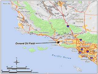
The Oxnard Oil Field is a large and productive oil field in and adjacent to the city of Oxnard, in Ventura County, California in the United States. Its conventional oil reserves are close to exhaustion, with only an estimated one percent of the original oil recoverable with current technology remaining: 434,000 barrels (69,000 m3) out of an original 43.5 million. However, the reservoir includes an enormous deposit of tar sands, ultra-heavy oil classed as an unconventional petroleum reserve, and potentially containing 400 million barrels (64,000,000 m3) of oil equivalent, should it become economically feasible to extract. Present operators on the field include Tri-Valley Oil & Gas Co., Anterra Energy Services, Inc., Chase Production Co., and Occidental Petroleum through its Vintage Production subsidiary. As of the beginning of 2009, there were 34 active wells on the field.

The Guijarral Hills Oil Field is a formerly-productive oil and gas field near Coalinga on the western side of the Central Valley in central California in the United States. Discovered in 1948, and having produced 5.4 million barrels (860,000 m3) of oil during its peak year in 1950, it now has but one active oil well producing a little over a barrel of oil a day, and is very near to exhaustion, with only 343,000 recoverable barrels of oil remaining throughout its 2,515-acre (10.18 km2) extent according to the official California State Department of Conservation estimate. As of 2010, the only active operator was Longview Production Company.

The California oil and gas industry has been a major economic and cultural component of the US state of California for over a century. Oil production was a minor factor in the 19th century, with kerosene replacing whale oil and lubricants becoming essential to the machine age. Oil became a major California industry in the 20th century with the discovery on new fields around Los Angeles and the San Joaquin Valley, and the dramatic increase in demand for gasoline to fuel automobiles and trucks. In 1900 California pumped 4 million barrels (640,000 m3), nearly 5% of the national supply. Then came a series of major discoveries, and the state pumped 100 million bbl (16 million m3) in 1914, or 38% of the national supply. In 2012 California produced 197 million bbl (31 million m3) of crude oil, out of the total 2,375 million bbl (378 million m3) of oil produced in the US, representing 8.3% of national production. California drilling operations and oil production are concentrated primarily in Kern County, San Joaquin Valley and the Los Angeles basin.
According to the United States Energy Information Administration (EIA), Pakistan may have over 9 billion barrels (1.4×10⁹ cubic metres) of petroleum oil and 105 trillion cubic feet (3.0 trillion cubic metres) in natural gas (including shale gas) reserves.
References
- 1 2 3 Hein, Rebecca. "Five Wyoming Oil Fields and the Transformation of an Economy". wyohistory.org. Wyoming State Historical Society. Retrieved 16 December 2016.
- 1 2 3 4 Rosenberg, Robert G. (July 21, 2004). "National Register of Historic Places Supplementary Listing Record: Commerce Block". National Park Service.
- ↑ Olson, W.G. (1949). "Powder River Basin; 4th Annual Field Conference Guidebook, 1949: Big Muddy Field, Converse County, Wyoming". Wyoming Geological Association.
- ↑ Olson, W.G. (1957). "History of the Big Muddy and South Glenrock Oil Fields". Wyoming Geological Association.
- ↑ Roberts, Phil. "A New History of Wyoming:History of Oil in Wyoming". University of Wyoming. Archived from the original on 20 December 2016. Retrieved 16 December 2016.
- ↑ Popovitch, Trish (April 6, 2017). "Big Muddy: A Footprint of the Past". Glenrock Independent. Retrieved 28 January 2024.